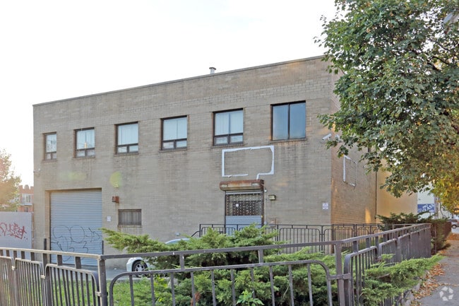
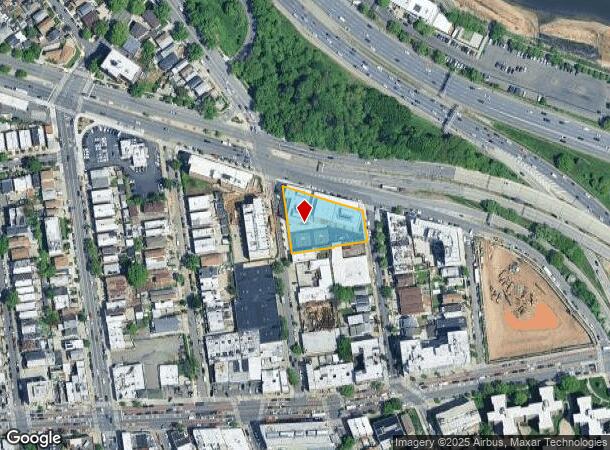
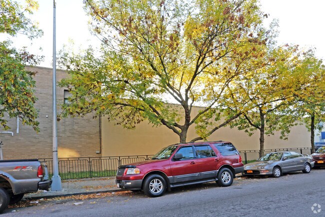
Property Record
11110 Astoria Blvd, East Elmhurst, NY 11369

NEARBY LISTINGS FOR SALE OR LEASE
Property Detail
11110 Astoria Blvd
01705-0001
Macpeters Ests Inc
Publicschool
Queens
X
New York
3604970113F
1
0
0.75 AC
2025
Northeast Queens
037300
Long Island (New York)
76,588 SF
New York-Jersey City-White Plains, NY-NJ
DEMOGRAPHICS near 11110 Astoria Blvd
1 Mile
3 Mile
5 Mile
2024 Total Population
89,491
793,710
1,890,691
2029 Population
81,442
743,913
1,767,261
Pop Growth 2024-2029
(8.99%)
(6.27%)
(6.53%)
Average Age
37
42
41
2024 Total Households
23,872
277,220
696,080
HH Growth 2024-2029
(9.37%)
(6.35%)
(6.72%)
Median Household Inc
$65,285
$66,092
$68,142
Avg Household Size
3.50
2.70
2.60
2024 Avg HH Vehicles
1.00
1.00
1.00
Median Home Value
$656,872
$659,267
$702,209
Median Year Built
1951
1955
1954
Nearby Places
- Restaurants
- Banks
- Shops
- Fitness
- Groceries
PUBLIC TRANSPORTATION
TRANSIT/SUBWAY
111 Street (7 Line) (7 - New York MTA Subway (The Subway))
DRIVE
WALK
Distance
111 Street (7 Line) (7 - New York MTA Subway (The Subway))
4 min
13 min
0.6 mi
103 Street-Corona Plaza (7 - New York MTA Subway (The Subway))
DRIVE
WALK
Distance
103 Street-Corona Plaza (7 - New York MTA Subway (The Subway))
5 min
19 min
0.9 mi
COMMUTER RAIL
Flushing-Main Street Station (Port Washington Branch - Long Island Rail Road)
DRIVE
WALK
Distance
Flushing-Main Street Station (Port Washington Branch - Long Island Rail Road)
7 min
2.1 mi
Murray Hill Station (Port Washington Branch - Long Island Rail Road)
DRIVE
WALK
Distance
Murray Hill Station (Port Washington Branch - Long Island Rail Road)
8 min
2.8 mi
AIRPORT
LaGuardia
DRIVE
WALK
Distance
LaGuardia
7 min
2.0 mi
John F Kennedy International
DRIVE
WALK
Distance
John F Kennedy International
15 min
10.4 mi
Newark Liberty International
DRIVE
WALK
Distance
Newark Liberty International
39 min
24.0 mi
SALE & LEASE HISTORY
LISTING DATE
SALE/LEASE

Sep 23, 2016
For Sale
Nearby Properties
Address
Land Use
TOTAL SIZE
Lot Size
Zoning
Address
Land Use
TOTAL SIZE
Lot Size
Zoning
5,519,372 SF
409.21 AC
C8-2
Address
Land Use
TOTAL SIZE
Lot Size
Zoning
2,078,606 SF
58.93 AC
R4
Address
Land Use
TOTAL SIZE
Lot Size
Zoning
1,258,350 SF
410.24 AC
PARK
Address
Land Use
TOTAL SIZE
Lot Size
Zoning
1,502,532 SF
6.35 AC
R7B
Address
Land Use
TOTAL SIZE
Lot Size
Zoning
772,163 SF
5.24 AC
C4-5X
Address
Land Use
TOTAL SIZE
Lot Size
Zoning
1,292,074 SF
C4-2F
Address
Land Use
TOTAL SIZE
Lot Size
Zoning
234,891 SF
3.17 AC
C4-5X
Address
Land Use
TOTAL SIZE
Lot Size
Zoning
1,516,458 SF
5.97 AC
R7-1
Address
Land Use
TOTAL SIZE
Lot Size
Zoning
15,000 SF
255.27 AC
PARK
Address
Land Use
TOTAL SIZE
Lot Size
Zoning
332,266 SF
12.57 AC
M2-1
Address
Land Use
TOTAL SIZE
Lot Size
Zoning
344,116 SF
0.92 AC
R7-1
Address
Land Use
TOTAL SIZE
Lot Size
Zoning
577,654 SF
5.38 AC
R6
Address
Land Use
TOTAL SIZE
Lot Size
Zoning
521,944 SF
16.68 AC
R4
Address
Land Use
TOTAL SIZE
Lot Size
Zoning
360,000 SF
5.88 AC
C4-2
Address
Land Use
TOTAL SIZE
Lot Size
Zoning
480,000 SF
16.98 AC
M1-1
Address
Land Use
TOTAL SIZE
Lot Size
Zoning
248,200 SF
1.25 AC
R6
Address
Land Use
TOTAL SIZE
Lot Size
Zoning
250,577 SF
23.17 AC
M2-1
Address
Land Use
TOTAL SIZE
Lot Size
Zoning
266,195 SF
4.59 AC
C4-2
Address
Land Use
TOTAL SIZE
Lot Size
Zoning
272,081 SF
4.59 AC
C4-2
Address
Land Use
TOTAL SIZE
Lot Size
Zoning
240,000 SF
2.09 AC
R6
Address
Land Use
TOTAL SIZE
Lot Size
Zoning
281,416 SF
2.57 AC
C4-2
Address
Land Use
TOTAL SIZE
Lot Size
Zoning
2,828 SF
78.05 AC
PARK
Address
Land Use
TOTAL SIZE
Lot Size
Zoning
192,200 SF
9.70 AC
R4
Address
Land Use
TOTAL SIZE
Lot Size
Zoning
454,631 SF
24.61 AC
M1-1
Address
Land Use
TOTAL SIZE
Lot Size
Zoning
4,279,575 SF
144.16 AC
PARK
Address
Land Use
TOTAL SIZE
Lot Size
Zoning
443,492 SF
27.75 AC
M1-1
Address
Land Use
TOTAL SIZE
Lot Size
Zoning
207,407 SF
3.73 AC
R6B
Address
Land Use
TOTAL SIZE
Lot Size
Zoning
454,645 SF
0.95 AC
C4-4
Address
Land Use
TOTAL SIZE
Lot Size
Zoning
202,615 SF
1.33 AC
R7-1
Address
Land Use
TOTAL SIZE
Lot Size
Zoning
15.83 AC
M2-1
The World's #1 Commercial Real Estate Marketplace
Connect with us
© 2025 CoStar Group
The information above has been obtained from sources believed reliable. While we do not doubt its accuracy we have not verified it and make no guarantee, warranty or representation about it. It is your responsibility to independently confirm its accuracy and completeness. Any projections, opinions, assumptions, or estimates used are for example only and do not represent the current or future performance of the property. The value of this transaction to you depends on tax and other factors which should be evaluated by your tax, financial, and legal advisors. You and your advisors should conduct a careful, independent investigation of the property to determine to your satisfaction the suitability of the property for your needs.