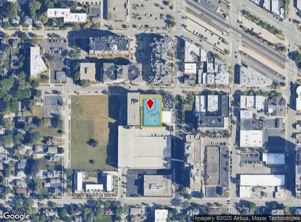
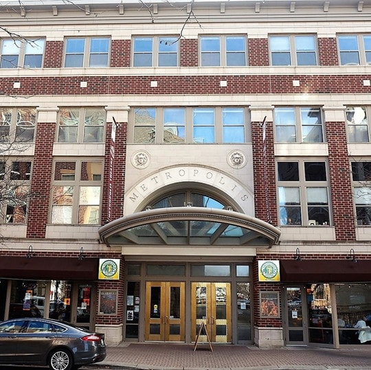
Property Record
111 W Campbell St, Arlington Heights, IL 60005


Current Lease Availabilities
NEARBY LISTINGS FOR SALE OR LEASE
Property Detail
111 W Campbell St
Taxexempt
Cook
X
Illinois
17031C0203J
Schaumburg Area
0
Chicago
2024
Chicago-Naperville-Elgin, IL-IN-WI
803300
03-29-346-037-1004
DEMOGRAPHICS near 111 W Campbell St
1 Mile
3 Mile
5 Mile
2024 Total Population
18,974
121,978
315,217
2029 Population
18,449
118,276
305,710
Pop Growth 2024-2029
(2.77%)
(3.03%)
(3.02%)
Average Age
42
43
42
2024 Total Households
7,659
48,213
123,785
HH Growth 2024-2029
(3.02%)
(3.39%)
(3.34%)
Median Household Inc
$119,246
$99,381
$91,678
Avg Household Size
2.40
2.50
2.50
2024 Avg HH Vehicles
2.00
2.00
2.00
Median Home Value
$430,631
$351,849
$335,716
Median Year Built
1964
1968
1972
Nearby Places
Map Layers
Map Styles
 Street
 Aerial
- Restaurants
- Banks
- Shops
- Fitness
- Groceries
PUBLIC TRANSPORTATION
COMMUTER RAIL
Arlington Heights Station (Union Pacific Northwest Line - Northeast Illinois Regional Commuter Railroad (Metra))
DRIVE
WALK
Distance
Arlington Heights Station (Union Pacific Northwest Line - Northeast Illinois Regional Commuter Railroad (Metra))
1 min
3 min
0.1 mi
Arlington Park Station (Union Pacific Northwest Line - Northeast Illinois Regional Commuter Railroad (Metra))
DRIVE
WALK
Distance
Arlington Park Station (Union Pacific Northwest Line - Northeast Illinois Regional Commuter Railroad (Metra))
6 min
1.6 mi
AIRPORT
Chicago O'Hare International
DRIVE
WALK
Distance
Chicago O'Hare International
23 min
13.1 mi
Chicago Midway International
DRIVE
WALK
Distance
Chicago Midway International
51 min
35.6 mi
Nearby Properties
Address
Land Use
TOTAL SIZE
Lot Size
Zoning
Address
Land Use
TOTAL SIZE
Lot Size
Zoning
32.56 AC
Address
Land Use
TOTAL SIZE
Lot Size
Zoning
Address
Land Use
TOTAL SIZE
Lot Size
Zoning
642,049 SF
33.14 AC
Address
Land Use
TOTAL SIZE
Lot Size
Zoning
510,788 SF
39.93 AC
Address
Land Use
TOTAL SIZE
Lot Size
Zoning
366,052 SF
32.18 AC
Address
Land Use
TOTAL SIZE
Lot Size
Zoning
303,671 SF
10.94 AC
Address
Land Use
TOTAL SIZE
Lot Size
Zoning
18.34 AC
Address
Land Use
TOTAL SIZE
Lot Size
Zoning
14,099 SF
2.01 AC
Address
Land Use
TOTAL SIZE
Lot Size
Zoning
262,533 SF
32.21 AC
Address
Land Use
TOTAL SIZE
Lot Size
Zoning
Address
Land Use
TOTAL SIZE
Lot Size
Zoning
29.21 AC
Address
Land Use
TOTAL SIZE
Lot Size
Zoning
303,701 SF
31.18 AC
Address
Land Use
TOTAL SIZE
Lot Size
Zoning
211,275 SF
21.67 AC
Address
Land Use
TOTAL SIZE
Lot Size
Zoning
195,269 SF
11.07 AC
Address
Land Use
TOTAL SIZE
Lot Size
Zoning
295,685 SF
27.21 AC
Address
Land Use
TOTAL SIZE
Lot Size
Zoning
283,822 SF
9.56 AC
Address
Land Use
TOTAL SIZE
Lot Size
Zoning
Address
Land Use
TOTAL SIZE
Lot Size
Zoning
304,912 SF
16.63 AC
Address
Land Use
TOTAL SIZE
Lot Size
Zoning
286,720 SF
9.77 AC
Address
Land Use
TOTAL SIZE
Lot Size
Zoning
45,259 SF
2.33 AC
Address
Land Use
TOTAL SIZE
Lot Size
Zoning
130,791 SF
8.41 AC
Address
Land Use
TOTAL SIZE
Lot Size
Zoning
138,926 SF
2.81 AC
Address
Land Use
TOTAL SIZE
Lot Size
Zoning
176,325 SF
18.20 AC
Address
Land Use
TOTAL SIZE
Lot Size
Zoning
17.21 AC
Address
Land Use
TOTAL SIZE
Lot Size
Zoning
152,773 SF
1.30 AC
Address
Land Use
TOTAL SIZE
Lot Size
Zoning
Address
Land Use
TOTAL SIZE
Lot Size
Zoning
332,283 SF
Address
Land Use
TOTAL SIZE
Lot Size
Zoning
51,028 SF
4.20 AC
Address
Land Use
TOTAL SIZE
Lot Size
Zoning
144,413 SF
6.46 AC
Address
Land Use
TOTAL SIZE
Lot Size
Zoning
The World's #1 Commercial Real Estate Marketplace
Connect with us
© 2025 CoStar Group
The information above has been obtained from sources believed reliable. While we do not doubt its accuracy we have not verified it and make no guarantee, warranty or representation about it. It is your responsibility to independently confirm its accuracy and completeness. Any projections, opinions, assumptions, or estimates used are for example only and do not represent the current or future performance of the property. The value of this transaction to you depends on tax and other factors which should be evaluated by your tax, financial, and legal advisors. You and your advisors should conduct a careful, independent investigation of the property to determine to your satisfaction the suitability of the property for your needs.