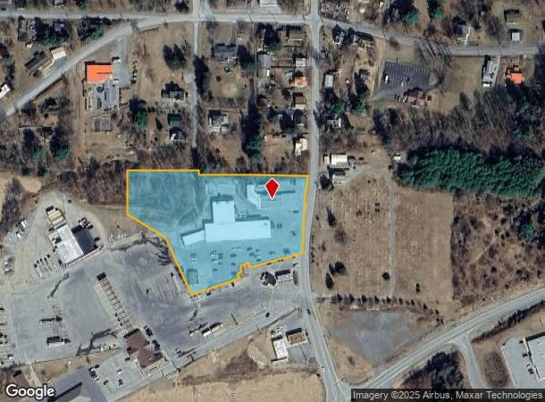
Property Record
131 Rolling Stone Rd, Morrisdale, PA 16858
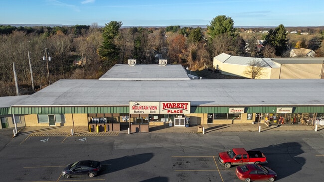
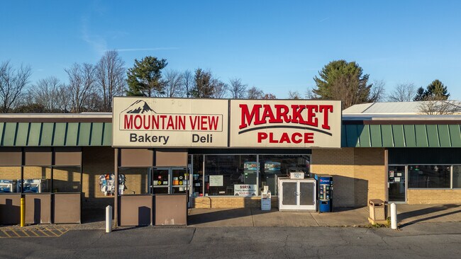
This Property Is For Sale
NEARBY LISTINGS FOR SALE OR LEASE
-
-
View all Morrisdale listings for sale on LoopNet.com
Property Detail
131 Rolling Stone Rd
1100R0800000047
BLDG & 3.903 A 131 ROLLING STONE RD
Commercialnec
Clearfield
X
Pennsylvania
42033C0535D
3.90 AC
2025
Pennsylvania Central Area
2025
Other Market Areas
330800
DuBois, PA
DEMOGRAPHICS near 131 Rolling Stone Rd
1 Mile
3 Mile
5 Mile
2024 Total Population
216
2,598
4,907
2029 Population
200
2,463
4,667
Pop Growth 2024-2029
(7.41%)
(5.20%)
(4.89%)
Average Age
43
43
44
2024 Total Households
88
1,074
2,040
HH Growth 2024-2029
(7.95%)
(5.12%)
(4.90%)
Median Household Inc
$73,392
$57,451
$60,609
Avg Household Size
2.50
2.40
2.40
2024 Avg HH Vehicles
3.00
2.00
2.00
Median Home Value
$157,692
$148,281
$145,241
Median Year Built
1978
1974
1974
Nearby Places
- Restaurants
- Banks
- Shops
- Fitness
- Groceries
PUBLIC TRANSPORTATION
AIRPORT
State College Regional
DRIVE
WALK
Distance
State College Regional
52 min
36.5 mi
Freight Ports
Port of Baltimore
DRIVE
WALK
Distance
Port of Baltimore
262 min
198.2 mi
Nearby Properties
Address
Land Use
TOTAL SIZE
Lot Size
Zoning
Address
Land Use
TOTAL SIZE
Lot Size
Zoning
31.92 AC
Address
Land Use
TOTAL SIZE
Lot Size
Zoning
Address
Land Use
TOTAL SIZE
Lot Size
Zoning
3.70 AC
Address
Land Use
TOTAL SIZE
Lot Size
Zoning
35.94 AC
Address
Land Use
TOTAL SIZE
Lot Size
Zoning
10.75 AC
Address
Land Use
TOTAL SIZE
Lot Size
Zoning
4.66 AC
Address
Land Use
TOTAL SIZE
Lot Size
Zoning
2.79 AC
Address
Land Use
TOTAL SIZE
Lot Size
Zoning
2.82 AC
Address
Land Use
TOTAL SIZE
Lot Size
Zoning
3.91 AC
Address
Land Use
TOTAL SIZE
Lot Size
Zoning
1,107.90 AC
Address
Land Use
TOTAL SIZE
Lot Size
Zoning
0.52 AC
Address
Land Use
TOTAL SIZE
Lot Size
Zoning
13.56 AC
Address
Land Use
TOTAL SIZE
Lot Size
Zoning
Address
Land Use
TOTAL SIZE
Lot Size
Zoning
Address
Land Use
TOTAL SIZE
Lot Size
Zoning
Address
Land Use
TOTAL SIZE
Lot Size
Zoning
2.52 AC
Address
Land Use
TOTAL SIZE
Lot Size
Zoning
4.51 AC
Address
Land Use
TOTAL SIZE
Lot Size
Zoning
14.72 AC
Address
Land Use
TOTAL SIZE
Lot Size
Zoning
10.02 AC
Address
Land Use
TOTAL SIZE
Lot Size
Zoning
Address
Land Use
TOTAL SIZE
Lot Size
Zoning
Address
Land Use
TOTAL SIZE
Lot Size
Zoning
2.78 AC
Address
Land Use
TOTAL SIZE
Lot Size
Zoning
Address
Land Use
TOTAL SIZE
Lot Size
Zoning
Address
Land Use
TOTAL SIZE
Lot Size
Zoning
4.03 AC
Address
Land Use
TOTAL SIZE
Lot Size
Zoning
Address
Land Use
TOTAL SIZE
Lot Size
Zoning
26.50 AC
Address
Land Use
TOTAL SIZE
Lot Size
Zoning
58.37 AC
Address
Land Use
TOTAL SIZE
Lot Size
Zoning
0.33 AC
The World's #1 Commercial Real Estate Marketplace
Connect with us
© 2025 CoStar Group
The information above has been obtained from sources believed reliable. While we do not doubt its accuracy we have not verified it and make no guarantee, warranty or representation about it. It is your responsibility to independently confirm its accuracy and completeness. Any projections, opinions, assumptions, or estimates used are for example only and do not represent the current or future performance of the property. The value of this transaction to you depends on tax and other factors which should be evaluated by your tax, financial, and legal advisors. You and your advisors should conduct a careful, independent investigation of the property to determine to your satisfaction the suitability of the property for your needs.