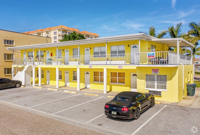
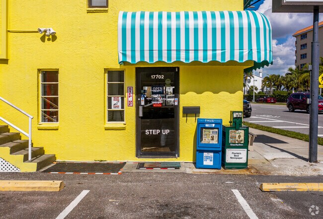
Property Record
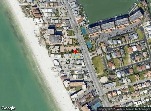
111 177Th Ave W, Redington Shores, FL 33708

NEARBY LISTINGS FOR SALE OR LEASE
Property Detail
111 177Th Ave W
Tampa-St. Petersburg-Clearwater, FL
Harbor Shores Sub
31-30-15-36304-000-0460
HARBOR SHORES SUB LOTS 46 AND 47
Apartment
Pinellas
AE
Florida
12103C0179H
46,47
2024
0.13 AC
2025
Redington Shores
027704
Tampa/St Petersburg
3,996 SF
DEMOGRAPHICS near 111 177Th Ave W
1 Mile
3 Mile
5 Mile
2024 Total Population
5,567
48,956
114,096
2029 Population
5,932
49,871
115,865
Pop Growth 2024-2029
+ 6.56%
+ 1.87%
+ 1.55%
Average Age
56
51
50
2024 Total Households
2,857
23,209
54,507
HH Growth 2024-2029
+ 6.58%
+ 2.16%
+ 1.68%
Median Household Inc
$91,938
$76,440
$69,285
Avg Household Size
1.90
2.10
2.00
2024 Avg HH Vehicles
2.00
2.00
2.00
Median Home Value
$556,133
$381,756
$331,017
Median Year Built
1976
1975
1975
Nearby Places
Map Layers
Map Styles
 Street
 Aerial
- Restaurants
- Banks
- Shops
- Fitness
- Groceries
PUBLIC TRANSPORTATION
AIRPORT
St Pete-Clearwater International
DRIVE
WALK
Distance
St Pete-Clearwater International
29 min
14.9 mi
Tampa International
DRIVE
WALK
Distance
Tampa International
46 min
27.6 mi
Sarasota/Bradenton International
DRIVE
WALK
Distance
Sarasota/Bradenton International
70 min
43.3 mi
Freight Ports
Port of Tampa Bay
DRIVE
WALK
Distance
Port of Tampa Bay
53 min
31.9 mi
Nearby Properties
Address
Land Use
TOTAL SIZE
Lot Size
Zoning
Address
Land Use
TOTAL SIZE
Lot Size
Zoning
372,952 SF
31.56 AC
Address
Land Use
TOTAL SIZE
Lot Size
Zoning
453,486 SF
15.73 AC
Address
Land Use
TOTAL SIZE
Lot Size
Zoning
223,748 SF
100.32 AC
R3
Address
Land Use
TOTAL SIZE
Lot Size
Zoning
101,642 SF
1.43 AC
Address
Land Use
TOTAL SIZE
Lot Size
Zoning
267,730 SF
35.84 AC
AE
Address
Land Use
TOTAL SIZE
Lot Size
Zoning
5,647 SF
187.56 AC
AE
Address
Land Use
TOTAL SIZE
Lot Size
Zoning
29,644 SF
19.13 AC
Address
Land Use
TOTAL SIZE
Lot Size
Zoning
160,086 SF
1.18 AC
Address
Land Use
TOTAL SIZE
Lot Size
Zoning
236,240 SF
12.38 AC
RPD15
Address
Land Use
TOTAL SIZE
Lot Size
Zoning
222,888 SF
11.83 AC
RPD15
Address
Land Use
TOTAL SIZE
Lot Size
Zoning
385,858 SF
8.83 AC
Address
Land Use
TOTAL SIZE
Lot Size
Zoning
4,704 SF
3.36 AC
Address
Land Use
TOTAL SIZE
Lot Size
Zoning
133,440 SF
6.85 AC
RM15
Address
Land Use
TOTAL SIZE
Lot Size
Zoning
176,209 SF
27.52 AC
Address
Land Use
TOTAL SIZE
Lot Size
Zoning
440 SF
3.47 AC
Address
Land Use
TOTAL SIZE
Lot Size
Zoning
160,134 SF
18.61 AC
R2
Address
Land Use
TOTAL SIZE
Lot Size
Zoning
84,008 SF
1.49 AC
Address
Land Use
TOTAL SIZE
Lot Size
Zoning
151,149 SF
8.84 AC
RM15
Address
Land Use
TOTAL SIZE
Lot Size
Zoning
160,616 SF
11.88 AC
Address
Land Use
TOTAL SIZE
Lot Size
Zoning
147,755 SF
6.86 AC
Address
Land Use
TOTAL SIZE
Lot Size
Zoning
36,102 SF
2.32 AC
Address
Land Use
TOTAL SIZE
Lot Size
Zoning
57,532 SF
6.96 AC
Address
Land Use
TOTAL SIZE
Lot Size
Zoning
62,578 SF
5.45 AC
Address
Land Use
TOTAL SIZE
Lot Size
Zoning
235,268 SF
3.01 AC
Address
Land Use
TOTAL SIZE
Lot Size
Zoning
133,610 SF
12.84 AC
Address
Land Use
TOTAL SIZE
Lot Size
Zoning
23,571 SF
55.32 AC
PSP
Address
Land Use
TOTAL SIZE
Lot Size
Zoning
83,103 SF
12.59 AC
AE
Address
Land Use
TOTAL SIZE
Lot Size
Zoning
56,655 SF
5.98 AC
R3
Address
Land Use
TOTAL SIZE
Lot Size
Zoning
9.55 AC
Address
Land Use
TOTAL SIZE
Lot Size
Zoning
116,039 SF
4.58 AC
The World's #1 Commercial Real Estate Marketplace
Connect with us
© 2025 CoStar Group
The information above has been obtained from sources believed reliable. While we do not doubt its accuracy we have not verified it and make no guarantee, warranty or representation about it. It is your responsibility to independently confirm its accuracy and completeness. Any projections, opinions, assumptions, or estimates used are for example only and do not represent the current or future performance of the property. The value of this transaction to you depends on tax and other factors which should be evaluated by your tax, financial, and legal advisors. You and your advisors should conduct a careful, independent investigation of the property to determine to your satisfaction the suitability of the property for your needs.