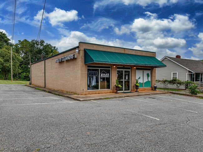
Property Record
111 E College Ave, Boiling Springs, NC 28017

Property Detail
111 E College Ave
1073
LOT HWY 150
Storebuilding
CLEVELAND
B1
North Carolina
B and X Area of moderate flood hazard, usually the area between the limits of the 100-year and 500-year floods.
16
2025
0.39 AC
2025
Cleveland County
951501
Charlotte
2,100 SF
Shelby-Kings Mountain, NC
NEARBY LISTINGS FOR SALE OR LEASE
-
-
View all Boiling Springs listings for sale on LoopNet.com
DEMOGRAPHICS near 111 E College Ave
1 mile
3 mile
5 mile
2025 Total Population
2,661
7,552
14,411
2030 Population
2,688
7,642
14,603
Pop Growth 2025-2030
+ 1.01%
+ 1.19%
+ 1.33%
Average Age
35
38
40
2025 Total Households
766
2,553
5,282
HH Growth 2025-2030
+ 0.65%
+ 1.02%
+ 1.25%
Median Household Inc
$85,565
$82,467
$74,006
Avg Household Size
2.50
2.50
2.50
2025 Avg HH Vehicles
2.00
2.00
2.00
Median Home Value
$241,441
$246,128
$241,442
Median Year Built
1986
1989
1987
Nearby Places
Map Layers
Map Styles
 Street
 Aerial
Transit
 Traffic
 Biking
Places
Listings with unknown addresses are not visible on the map
- Restaurants
- Banks
- Shops
- Fitness
- Groceries
SALE & LEASE HISTORY
LISTING DATE
SALE/LEASE

Jan 08, 2024
For Sale
Aug 23, 2022
For Sale
Nearby Properties
Address
Land Use
TOTAL SIZE
Lot Size
Zoning
Address
Land Use
TOTAL SIZE
Lot Size
Zoning
44,586 SF
23.45 AC
I1
Address
Land Use
TOTAL SIZE
Lot Size
Zoning
157,347 SF
0.98 AC
I1
Address
Land Use
TOTAL SIZE
Lot Size
Zoning
21,376 SF
14 AC
I1
Address
Land Use
TOTAL SIZE
Lot Size
Zoning
79,077 SF
29.37 AC
R15
Address
Land Use
TOTAL SIZE
Lot Size
Zoning
85,141 SF
25.07 AC
I1
Address
Land Use
TOTAL SIZE
Lot Size
Zoning
1,246 SF
30 AC
I1
Address
Land Use
TOTAL SIZE
Lot Size
Zoning
64,773 SF
25.95 AC
I1
Address
Land Use
TOTAL SIZE
Lot Size
Zoning
42,668 SF
30.28 AC
R20
Address
Land Use
TOTAL SIZE
Lot Size
Zoning
53,750 SF
35.55 AC
I1
Address
Land Use
TOTAL SIZE
Lot Size
Zoning
2,008 SF
22.40 AC
I1
Address
Land Use
TOTAL SIZE
Lot Size
Zoning
2,320 SF
27.30 AC
R15
Address
Land Use
TOTAL SIZE
Lot Size
Zoning
28,672 SF
3 AC
B1
Address
Land Use
TOTAL SIZE
Lot Size
Zoning
3,230 SF
16.45 AC
I1
Address
Land Use
TOTAL SIZE
Lot Size
Zoning
20,282 SF
13.68 AC
R15
Address
Land Use
TOTAL SIZE
Lot Size
Zoning
8,908 SF
2.23 AC
OCS
Address
Land Use
TOTAL SIZE
Lot Size
Zoning
11,127 SF
1.28 AC
B1
Address
Land Use
TOTAL SIZE
Lot Size
Zoning
41,500 SF
9.80 AC
B1
Address
Land Use
TOTAL SIZE
Lot Size
Zoning
7,998 SF
6.84 AC
R15
Address
Land Use
TOTAL SIZE
Lot Size
Zoning
12,279 SF
1.48 AC
B1
Address
Land Use
TOTAL SIZE
Lot Size
Zoning
18,906 SF
10.35 AC
R10
Address
Land Use
TOTAL SIZE
Lot Size
Zoning
8,451 SF
2.92 AC
B1
Address
Land Use
TOTAL SIZE
Lot Size
Zoning
12,760 SF
1.94 AC
Address
Land Use
TOTAL SIZE
Lot Size
Zoning
2,394 SF
2.30 AC
I1
Address
Land Use
TOTAL SIZE
Lot Size
Zoning
3,704 SF
1.37 AC
B1
Address
Land Use
TOTAL SIZE
Lot Size
Zoning
5,104 SF
8.64 AC
R15
Address
Land Use
TOTAL SIZE
Lot Size
Zoning
19,687 SF
1.58 AC
R10
Address
Land Use
TOTAL SIZE
Lot Size
Zoning
4,251 SF
0.63 AC
B1
Address
Land Use
TOTAL SIZE
Lot Size
Zoning
4,032 SF
0.93 AC
B1
Address
Land Use
TOTAL SIZE
Lot Size
Zoning
12,000 SF
6.04 AC
R20
Address
Land Use
TOTAL SIZE
Lot Size
Zoning
7,225 SF
1.29 AC
R15
The World's #1 Commercial Real Estate Marketplace
Connect with us
© 2026 CoStar Group
The information above has been obtained from sources believed reliable. While we do not doubt its accuracy we have not verified it and make no guarantee, warranty or representation about it. It is your responsibility to independently confirm its accuracy and completeness. Any projections, opinions, assumptions, or estimates used are for example only and do not represent the current or future performance of the property. The value of this transaction to you depends on tax and other factors which should be evaluated by your tax, financial, and legal advisors. You and your advisors should conduct a careful, independent investigation of the property to determine to your satisfaction the suitability of the property for your needs.