Property Record
111 Matthew Warren Dr, Clinton, TN 37716
NEARBY LISTINGS FOR SALE OR LEASE
Property Detail
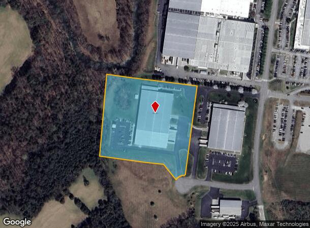
111 Matthew Warren Dr
Knoxville, TN
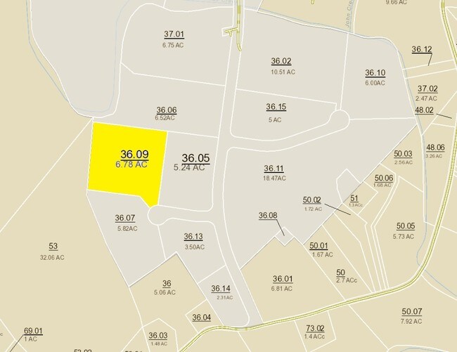
Resub
055-036.09
PB: 6 PG: 119D LOT: 4R1
Industrialgeneral
Anderson
AE
Tennessee
47001C0139G
4r1
2024
6.78 AC
2025
Anderson County
020902
Knoxville
70,739 SF
DEMOGRAPHICS near 111 Matthew Warren Dr
1 Mile
3 Mile
5 Mile
2024 Total Population
1,030
6,841
21,933
2029 Population
1,090
7,227
23,233
Pop Growth 2024-2029
+ 5.83%
+ 5.64%
+ 5.93%
Average Age
42
42
42
2024 Total Households
412
2,777
8,916
HH Growth 2024-2029
+ 5.58%
+ 5.69%
+ 5.93%
Median Household Inc
$63,214
$60,070
$57,620
Avg Household Size
2.50
2.40
2.40
2024 Avg HH Vehicles
3.00
2.00
2.00
Median Home Value
$186,282
$208,938
$201,099
Median Year Built
1989
1989
1984
Nearby Places
- Restaurants
- Banks
- Shops
- Fitness
- Groceries
PUBLIC TRANSPORTATION
AIRPORT
McGhee Tyson
DRIVE
WALK
Distance
McGhee Tyson
59 min
35.5 mi
Freight Ports
North Charleston Terminal
DRIVE
WALK
Distance
North Charleston Terminal
445 min
382.0 mi
Nearby Properties
Address
Land Use
TOTAL SIZE
Lot Size
Zoning
Address
Land Use
TOTAL SIZE
Lot Size
Zoning
137,172 SF
48 AC
Address
Land Use
TOTAL SIZE
Lot Size
Zoning
274,553 SF
48.01 AC
Address
Land Use
TOTAL SIZE
Lot Size
Zoning
239,700 SF
36.16 AC
Address
Land Use
TOTAL SIZE
Lot Size
Zoning
285,877 SF
42.49 AC
Address
Land Use
TOTAL SIZE
Lot Size
Zoning
199,093 SF
22.61 AC
Address
Land Use
TOTAL SIZE
Lot Size
Zoning
24,324 SF
2 AC
Address
Land Use
TOTAL SIZE
Lot Size
Zoning
162,211 SF
10.51 AC
Address
Land Use
TOTAL SIZE
Lot Size
Zoning
128,370 SF
6.52 AC
Address
Land Use
TOTAL SIZE
Lot Size
Zoning
47,159 SF
2.15 AC
Address
Land Use
TOTAL SIZE
Lot Size
Zoning
Address
Land Use
TOTAL SIZE
Lot Size
Zoning
36,543 SF
16.51 AC
Address
Land Use
TOTAL SIZE
Lot Size
Zoning
56,912 SF
2.59 AC
Address
Land Use
TOTAL SIZE
Lot Size
Zoning
54,582 SF
9.18 AC
B4
Address
Land Use
TOTAL SIZE
Lot Size
Zoning
178,253 SF
20 AC
Address
Land Use
TOTAL SIZE
Lot Size
Zoning
42,152 SF
1.31 AC
Address
Land Use
TOTAL SIZE
Lot Size
Zoning
43,512 SF
8.81 AC
Address
Land Use
TOTAL SIZE
Lot Size
Zoning
63,467 SF
10.56 AC
Address
Land Use
TOTAL SIZE
Lot Size
Zoning
15,382 SF
36 AC
Address
Land Use
TOTAL SIZE
Lot Size
Zoning
98,418 SF
9.36 AC
Address
Land Use
TOTAL SIZE
Lot Size
Zoning
35,368 SF
5 AC
Address
Land Use
TOTAL SIZE
Lot Size
Zoning
161,360 SF
6.75 AC
Address
Land Use
TOTAL SIZE
Lot Size
Zoning
18,999 SF
11.50 AC
Address
Land Use
TOTAL SIZE
Lot Size
Zoning
67,144 SF
11.50 AC
Address
Land Use
TOTAL SIZE
Lot Size
Zoning
18,970 SF
2.90 AC
Address
Land Use
TOTAL SIZE
Lot Size
Zoning
27,720 SF
3.28 AC
Address
Land Use
TOTAL SIZE
Lot Size
Zoning
Address
Land Use
TOTAL SIZE
Lot Size
Zoning
89,166 SF
9.39 AC
Address
Land Use
TOTAL SIZE
Lot Size
Zoning
37,966 SF
4.32 AC
Address
Land Use
TOTAL SIZE
Lot Size
Zoning
25,608 SF
3.17 AC
Address
Land Use
TOTAL SIZE
Lot Size
Zoning
20,000 SF
4.99 AC
The World's #1 Commercial Real Estate Marketplace
Connect with us
© 2025 CoStar Group
The information above has been obtained from sources believed reliable. While we do not doubt its accuracy we have not verified it and make no guarantee, warranty or representation about it. It is your responsibility to independently confirm its accuracy and completeness. Any projections, opinions, assumptions, or estimates used are for example only and do not represent the current or future performance of the property. The value of this transaction to you depends on tax and other factors which should be evaluated by your tax, financial, and legal advisors. You and your advisors should conduct a careful, independent investigation of the property to determine to your satisfaction the suitability of the property for your needs.