Property Record
109 Mill Dam Rd, Centerport, NY 11721
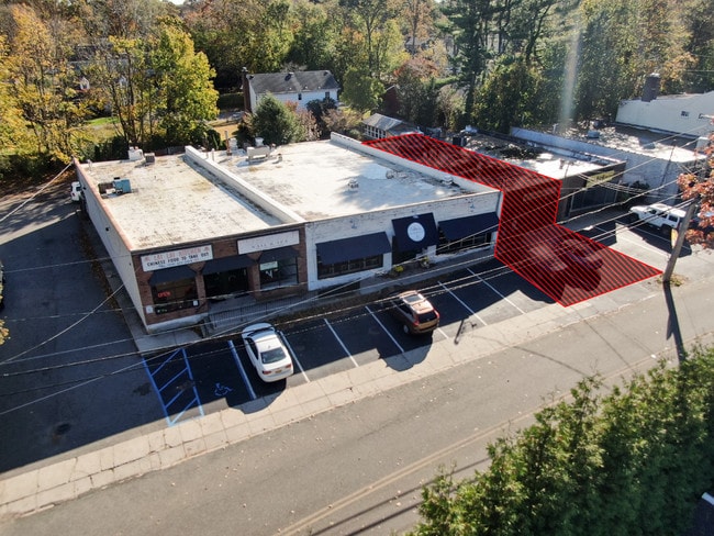


This Property Is For Sale
NEARBY LISTINGS FOR SALE OR LEASE
Property Detail
109 Mill Dam Rd
Long Island (New York)
Denton Hills
Nassau County-Suffolk County, NY
Suffolk
0400-040-00-04-00-007-003
New York
Townhouserowhouse
0.56 AC
X
Western Suffolk
36103C0319H
DEMOGRAPHICS near 109 Mill Dam Rd
1 Mile
3 Mile
5 Mile
2024 Total Population
6,919
58,227
137,463
2029 Population
6,826
57,174
134,622
Pop Growth 2024-2029
(1.34%)
(1.81%)
(2.07%)
Average Age
44
44
42
2024 Total Households
2,518
21,432
46,826
HH Growth 2024-2029
(1.51%)
(2.03%)
(2.27%)
Median Household Inc
$181,524
$142,661
$141,995
Avg Household Size
2.70
2.60
2.80
2024 Avg HH Vehicles
2.00
2.00
2.00
Median Home Value
$768,837
$713,171
$688,558
Median Year Built
1956
1958
1959
Nearby Places
Map Layers
Map Styles
 Street
 Aerial
- Restaurants
- Banks
- Shops
- Fitness
- Groceries
PUBLIC TRANSPORTATION
COMMUTER RAIL
Greenlawn Station (Port Jefferson Branch - Long Island Rail Road)
DRIVE
WALK
Distance
Greenlawn Station (Port Jefferson Branch - Long Island Rail Road)
8 min
2.6 mi
Huntington Station (Port Jefferson Branch - Long Island Rail Road)
DRIVE
WALK
Distance
Huntington Station (Port Jefferson Branch - Long Island Rail Road)
10 min
4.9 mi
AIRPORT
Long Island MacArthur
DRIVE
WALK
Distance
Long Island MacArthur
36 min
20.4 mi
LaGuardia
DRIVE
WALK
Distance
LaGuardia
51 min
32.4 mi
Freight Ports
NY - Red Hook Container Terminal
DRIVE
WALK
Distance
NY - Red Hook Container Terminal
62 min
40.5 mi
Nearby Properties
Address
Land Use
TOTAL SIZE
Lot Size
Zoning
Address
Land Use
TOTAL SIZE
Lot Size
Zoning
42.21 AC
CA
Address
Land Use
TOTAL SIZE
Lot Size
Zoning
0.80 AC
CR60
Address
Land Use
TOTAL SIZE
Lot Size
Zoning
0.49 AC
VILLA
Address
Land Use
TOTAL SIZE
Lot Size
Zoning
0.06 AC
VILLA
Address
Land Use
TOTAL SIZE
Lot Size
Zoning
0.06 AC
VILLA
Address
Land Use
TOTAL SIZE
Lot Size
Zoning
0.02 AC
VILLA
Address
Land Use
TOTAL SIZE
Lot Size
Zoning
0.04 AC
VILLA
Address
Land Use
TOTAL SIZE
Lot Size
Zoning
0.05 AC
VILLA
Address
Land Use
TOTAL SIZE
Lot Size
Zoning
2,764 SF
0.24 AC
HC
Address
Land Use
TOTAL SIZE
Lot Size
Zoning
0.05 AC
VILLA
Address
Land Use
TOTAL SIZE
Lot Size
Zoning
0.05 AC
VILLA
Address
Land Use
TOTAL SIZE
Lot Size
Zoning
0.05 AC
VILLA
Address
Land Use
TOTAL SIZE
Lot Size
Zoning
0.03 AC
VILLA
Address
Land Use
TOTAL SIZE
Lot Size
Zoning
0.04 AC
VILLA
Address
Land Use
TOTAL SIZE
Lot Size
Zoning
0.04 AC
VILLA
Address
Land Use
TOTAL SIZE
Lot Size
Zoning
0.03 AC
VILLA
Address
Land Use
TOTAL SIZE
Lot Size
Zoning
0.02 AC
VILLA
Address
Land Use
TOTAL SIZE
Lot Size
Zoning
0.04 AC
VILLA
Address
Land Use
TOTAL SIZE
Lot Size
Zoning
0.04 AC
VILLA
Address
Land Use
TOTAL SIZE
Lot Size
Zoning
0.04 AC
VILLA
Address
Land Use
TOTAL SIZE
Lot Size
Zoning
0.04 AC
VILLA
Address
Land Use
TOTAL SIZE
Lot Size
Zoning
1 AC
VILLA
Address
Land Use
TOTAL SIZE
Lot Size
Zoning
1.50 AC
R40
Address
Land Use
TOTAL SIZE
Lot Size
Zoning
11.85 AC
RMS
Address
Land Use
TOTAL SIZE
Lot Size
Zoning
0.04 AC
VILLA
Address
Land Use
TOTAL SIZE
Lot Size
Zoning
2.60 AC
R80
Address
Land Use
TOTAL SIZE
Lot Size
Zoning
0.03 AC
VILLA
Address
Land Use
TOTAL SIZE
Lot Size
Zoning
0.03 AC
VILLA
Address
Land Use
TOTAL SIZE
Lot Size
Zoning
0.03 AC
VILLA
Address
Land Use
TOTAL SIZE
Lot Size
Zoning
0.03 AC
VILLA
The World's #1 Commercial Real Estate Marketplace
Connect with us
© 2025 CoStar Group
The information above has been obtained from sources believed reliable. While we do not doubt its accuracy we have not verified it and make no guarantee, warranty or representation about it. It is your responsibility to independently confirm its accuracy and completeness. Any projections, opinions, assumptions, or estimates used are for example only and do not represent the current or future performance of the property. The value of this transaction to you depends on tax and other factors which should be evaluated by your tax, financial, and legal advisors. You and your advisors should conduct a careful, independent investigation of the property to determine to your satisfaction the suitability of the property for your needs.