Property Record
111 N 3Rd St, Ozark, AR 72949
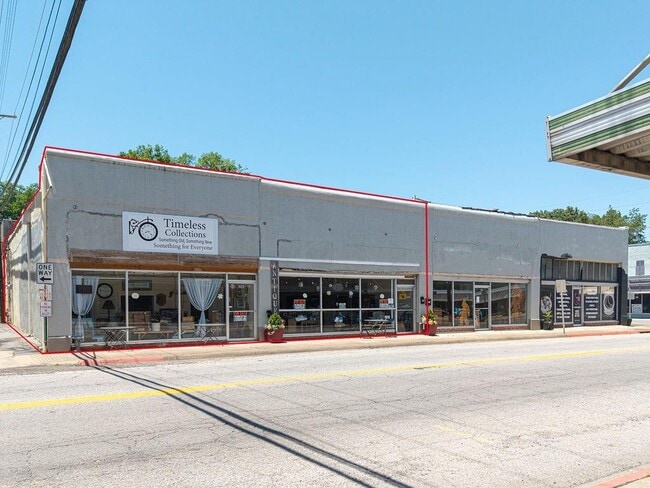

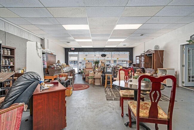
This Property Is For Sale
Property Detail
111 N 3Rd St
009-00866-000
A CERTAIN TRACT OF LAND LOCATED IN PART OF LOTS 1, 2 AND 3 OF BLOCK 19 OF THE ORIGINAL TOWN OF OZARK, FRANKLIN COUNTY, ARKANS
Storebuilding
FRANKLIN
B and X Area of moderate flood hazard, usually the area between the limits of the 100-year and 500-year floods.
Arkansas
2025
1,2
2025
0.05 AC
950202
Franklin County
2,000 SF
Fort Smith
NEARBY LISTINGS FOR SALE OR LEASE
DEMOGRAPHICS near 111 N 3Rd St
1 mile
3 mile
5 mile
2025 Total Population
2,294
5,134
7,044
2030 Population
2,386
5,298
7,270
Pop Growth 2025-2030
+ 4.01%
+ 3.19%
+ 3.21%
Average Age
40
40
41
2025 Total Households
957
2,045
2,797
HH Growth 2025-2030
+ 4.08%
+ 3.37%
+ 3.32%
Median Household Inc
$48,536
$47,922
$49,778
Avg Household Size
2.30
2.40
2.40
2025 Avg HH Vehicles
2.00
2.00
2.00
Median Home Value
$138,396
$127,214
$132,086
Median Year Built
1986
1984
1984
Nearby Places
Map Layers
Map Styles
 Street
 Aerial
Layers
 Traffic
 Biking
Places
Listings with unknown addresses are not visible on the map
- Restaurants
- Banks
- Shops
- Fitness
- Groceries
PUBLIC TRANSPORTATION
AIRPORT
Fort Smith Regional
Drive
Walk
Distance
Fort Smith Regional
53 min
42.4 mi
Nearby Properties
Address
Land Use
TOTAL SIZE
Lot Size
Zoning
Address
Land Use
TOTAL SIZE
Lot Size
Zoning
126,797 SF
18.88 AC
Address
Land Use
TOTAL SIZE
Lot Size
Zoning
157,822 SF
17.48 AC
Address
Land Use
TOTAL SIZE
Lot Size
Zoning
44,408 SF
0.30 AC
Address
Land Use
TOTAL SIZE
Lot Size
Zoning
36,960 SF
0.11 AC
Address
Land Use
TOTAL SIZE
Lot Size
Zoning
924 SF
4.39 AC
Address
Land Use
TOTAL SIZE
Lot Size
Zoning
13,944 SF
3.81 AC
Address
Land Use
TOTAL SIZE
Lot Size
Zoning
6,311 SF
4 AC
Address
Land Use
TOTAL SIZE
Lot Size
Zoning
32,298 SF
3.63 AC
Address
Land Use
TOTAL SIZE
Lot Size
Zoning
9,582 SF
2.38 AC
Address
Land Use
TOTAL SIZE
Lot Size
Zoning
19,253 SF
15.31 AC
Address
Land Use
TOTAL SIZE
Lot Size
Zoning
15,768 SF
1.54 AC
Address
Land Use
TOTAL SIZE
Lot Size
Zoning
7,308 SF
1.36 AC
Address
Land Use
TOTAL SIZE
Lot Size
Zoning
5,758 SF
8.25 AC
Address
Land Use
TOTAL SIZE
Lot Size
Zoning
22,236 SF
4.70 AC
Address
Land Use
TOTAL SIZE
Lot Size
Zoning
19,278 SF
8 AC
Address
Land Use
TOTAL SIZE
Lot Size
Zoning
8,498 SF
2.82 AC
Address
Land Use
TOTAL SIZE
Lot Size
Zoning
26,724 SF
1.26 AC
Address
Land Use
TOTAL SIZE
Lot Size
Zoning
8,566 SF
0.94 AC
Address
Land Use
TOTAL SIZE
Lot Size
Zoning
6,012 SF
3.10 AC
Address
Land Use
TOTAL SIZE
Lot Size
Zoning
6,936 SF
0.54 AC
Address
Land Use
TOTAL SIZE
Lot Size
Zoning
2,676 SF
1.14 AC
Address
Land Use
TOTAL SIZE
Lot Size
Zoning
12,672 SF
0.93 AC
Address
Land Use
TOTAL SIZE
Lot Size
Zoning
4,914 SF
1.68 AC
Address
Land Use
TOTAL SIZE
Lot Size
Zoning
11,200 SF
3.88 AC
Address
Land Use
TOTAL SIZE
Lot Size
Zoning
14,960 SF
1.38 AC
Address
Land Use
TOTAL SIZE
Lot Size
Zoning
13,712 SF
1.10 AC
Address
Land Use
TOTAL SIZE
Lot Size
Zoning
9,288 SF
5.41 AC
Address
Land Use
TOTAL SIZE
Lot Size
Zoning
4,580 SF
0.56 AC
Address
Land Use
TOTAL SIZE
Lot Size
Zoning
2,939 SF
1 AC
Address
Land Use
TOTAL SIZE
Lot Size
Zoning
6,392 SF
0.65 AC
The World's #1 Commercial Real Estate Marketplace
Connect with us
© 2026 CoStar Group
The information above has been obtained from sources believed reliable. While we do not doubt its accuracy we have not verified it and make no guarantee, warranty or representation about it. It is your responsibility to independently confirm its accuracy and completeness. Any projections, opinions, assumptions, or estimates used are for example only and do not represent the current or future performance of the property. The value of this transaction to you depends on tax and other factors which should be evaluated by your tax, financial, and legal advisors. You and your advisors should conduct a careful, independent investigation of the property to determine to your satisfaction the suitability of the property for your needs.