Property Record
111 N Main St, Galena, MD 21635


Save to a Folder
{{folder.Name}}
{{folder.ListingIds.length}} Properties
{{folder.ListingIds.length}} Property
Create a New Folder
Property Detail
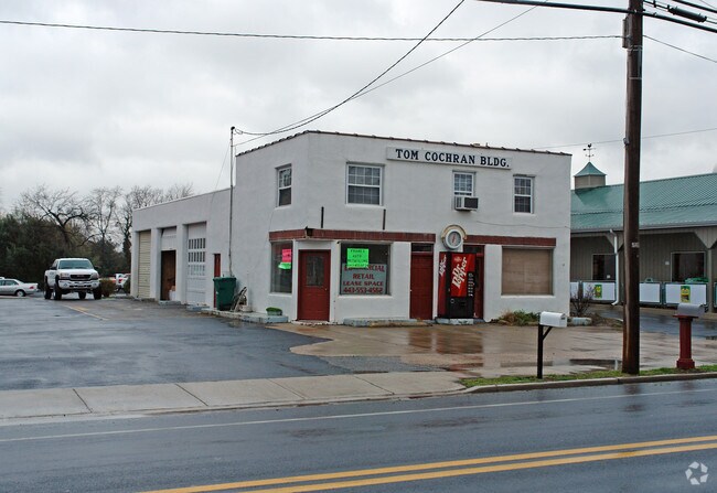
111 N Main St
Restaurantbuilding
LOT 0.386 AC 111 N MAIN ST GALENA
C-1
Kent
B and X Area of moderate flood hazard, usually the area between the limits of the 100-year and 500-year floods.
Maryland
2025
0.39 AC
2025
Kent County
950100
Baltimore
1,310 SF
01-003046
NEARBY LISTINGS FOR SALE OR LEASE
-
-
View all Galena listings for lease on LoopNet.com
DEMOGRAPHICS near 111 N Main St
1 mile
3 mile
5 mile
2025 Total Population
706
1,724
3,984
2030 Population
706
1,734
4,072
Pop Growth 2025-2030
0.00%
+ 0.58%
+ 2.21%
Average Age
46
46
44
2025 Total Households
300
733
1,597
HH Growth 2025-2030
+ 0.33%
+ 0.68%
+ 2.13%
Median Household Inc
$121,527
$126,537
$110,148
Avg Household Size
2.30
2.30
2.40
2025 Avg HH Vehicles
2.00
2.00
2.00
Median Home Value
$388,094
$386,457
$363,783
Median Year Built
1983
1983
1981
Nearby Places
Map Layers
Map Styles
 Street
 Aerial
Layers
 Traffic
 Biking
Places
Listings with unknown addresses are not visible on the map
- Restaurants
- Banks
- Shops
- Fitness
- Groceries
SALE & LEASE HISTORY
LISTING DATE
SALE/LEASE

Oct 10, 2023
For Lease
Nearby Properties
Address
Land Use
TOTAL SIZE
Lot Size
Zoning
Address
Land Use
TOTAL SIZE
Lot Size
Zoning
6.59 AC
RCA
Address
Land Use
TOTAL SIZE
Lot Size
Zoning
58,880 SF
8.30 AC
Address
Land Use
TOTAL SIZE
Lot Size
Zoning
3,157 SF
14.27 AC
LM
Address
Land Use
TOTAL SIZE
Lot Size
Zoning
15.69 AC
MB
Address
Land Use
TOTAL SIZE
Lot Size
Zoning
3.01 AC
MB
Address
Land Use
TOTAL SIZE
Lot Size
Zoning
4,500 SF
3.08 AC
C
Address
Land Use
TOTAL SIZE
Lot Size
Zoning
2.16 AC
MB
Address
Land Use
TOTAL SIZE
Lot Size
Zoning
4,560 SF
134.54 AC
AZD
Address
Land Use
TOTAL SIZE
Lot Size
Zoning
7.88 AC
MB
Address
Land Use
TOTAL SIZE
Lot Size
Zoning
2.05 AC
MB
Address
Land Use
TOTAL SIZE
Lot Size
Zoning
605.04 AC
RCDRR
Address
Land Use
TOTAL SIZE
Lot Size
Zoning
5,016 SF
5.67 AC
RR
Address
Land Use
TOTAL SIZE
Lot Size
Zoning
12,677 SF
1.98 AC
CM
Address
Land Use
TOTAL SIZE
Lot Size
Zoning
18,000 SF
10.19 AC
RR
Address
Land Use
TOTAL SIZE
Lot Size
Zoning
9,840 SF
6 AC
LM
Address
Land Use
TOTAL SIZE
Lot Size
Zoning
4,964 SF
13.14 AC
RR
Address
Land Use
TOTAL SIZE
Lot Size
Zoning
8,007 SF
1.40 AC
Address
Land Use
TOTAL SIZE
Lot Size
Zoning
2,016 SF
3.42 AC
CAR
Address
Land Use
TOTAL SIZE
Lot Size
Zoning
24,240 SF
2.91 AC
R-2
Address
Land Use
TOTAL SIZE
Lot Size
Zoning
10,640 SF
1.65 AC
Address
Land Use
TOTAL SIZE
Lot Size
Zoning
4.34 AC
RR
Address
Land Use
TOTAL SIZE
Lot Size
Zoning
3,200 SF
8.65 AC
V
Address
Land Use
TOTAL SIZE
Lot Size
Zoning
4,536 SF
0.78 AC
C-1
Address
Land Use
TOTAL SIZE
Lot Size
Zoning
3,693 SF
270.04 AC
AZD
Address
Land Use
TOTAL SIZE
Lot Size
Zoning
4,218 SF
0.68 AC
C
Address
Land Use
TOTAL SIZE
Lot Size
Zoning
2,240 SF
0.33 AC
Address
Land Use
TOTAL SIZE
Lot Size
Zoning
1,404 SF
0.70 AC
CAR
Address
Land Use
TOTAL SIZE
Lot Size
Zoning
17.58 AC
RCDRR
Address
Land Use
TOTAL SIZE
Lot Size
Zoning
35 AC
R-1
The World's #1 Commercial Real Estate Marketplace
Connect with us
© 2026 CoStar Group
The information above has been obtained from sources believed reliable. While we do not doubt its accuracy we have not verified it and make no guarantee, warranty or representation about it. It is your responsibility to independently confirm its accuracy and completeness. Any projections, opinions, assumptions, or estimates used are for example only and do not represent the current or future performance of the property. The value of this transaction to you depends on tax and other factors which should be evaluated by your tax, financial, and legal advisors. You and your advisors should conduct a careful, independent investigation of the property to determine to your satisfaction the suitability of the property for your needs.