Property Record
111 Nw Lyman Rd, Topeka, KS 66608

Save to a Folder
{{folder.Name}}
{{folder.ListingIds.length}} Properties
{{folder.ListingIds.length}} Property
Create a New Folder
Property Detail
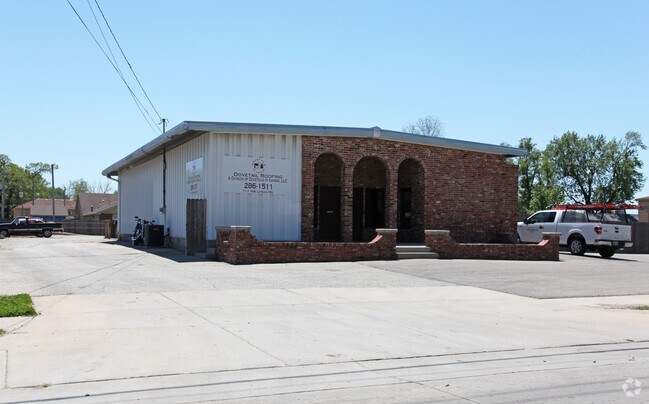
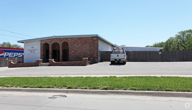
111 Nw Lyman Rd
Topeka, KS
J W HARDT , LOT 18 + , LTS 18 THRU 34 & S 10 LT 36 SECTION 20 TOWNSHIP 11 RANGE 16
104-20-0-20-01-002-000
Shawnee
Commercialnec
Kansas
C4
18
2024
0.71 AC
2025
Topeka
000800
Kansas City
3,712 SF
NEARBY LISTINGS FOR SALE OR LEASE
DEMOGRAPHICS near 111 Nw Lyman Rd
1 mile
3 mile
5 mile
2025 Total Population
3,872
27,073
78,073
2030 Population
3,919
27,395
78,555
Pop Growth 2025-2030
+ 1.21%
+ 1.19%
+ 0.62%
Average Age
41
41
40
2025 Total Households
1,666
11,272
31,982
HH Growth 2025-2030
+ 1.14%
+ 1.37%
+ 0.70%
Median Household Inc
$48,177
$48,871
$53,061
Avg Household Size
2.20
2.20
2.30
2025 Avg HH Vehicles
2.00
2.00
2.00
Median Home Value
$113,378
$109,412
$135,425
Median Year Built
1969
1951
1957
Nearby Places
Map Layers
Map Styles
 Street
 Aerial
Layers
 Traffic
 Biking
Places
Listings with unknown addresses are not visible on the map
- Restaurants
- Banks
- Shops
- Fitness
- Groceries
PUBLIC TRANSPORTATION
COMMUTER RAIL
Topeka Amtrak Station (Southwest Chief - Amtrak)
Drive
Walk
Distance
Topeka Amtrak Station (Southwest Chief - Amtrak)
7 min
3.1 mi
Freight Ports
Tulsa Port Of Catoosa
Drive
Walk
Distance
Tulsa Port Of Catoosa
282 min
228.7 mi
Nearby Properties
Address
Land Use
TOTAL SIZE
Lot Size
Zoning
Address
Land Use
TOTAL SIZE
Lot Size
Zoning
52,453 SF
17.12 AC
C5,OI2
Address
Land Use
TOTAL SIZE
Lot Size
Zoning
309,298 SF
7.34 AC
M1
Address
Land Use
TOTAL SIZE
Lot Size
Zoning
64,058 SF
3.31 AC
C4,OI2
Address
Land Use
TOTAL SIZE
Lot Size
Zoning
65,687 SF
7.47 AC
C2,I1,M2
Address
Land Use
TOTAL SIZE
Lot Size
Zoning
137,637 SF
10.43 AC
M2
Address
Land Use
TOTAL SIZE
Lot Size
Zoning
90,929 SF
8.68 AC
PUD,OI3,I1
Address
Land Use
TOTAL SIZE
Lot Size
Zoning
98,898 SF
1.91 AC
C5
Address
Land Use
TOTAL SIZE
Lot Size
Zoning
181,781 SF
569.17 AC
R1
Address
Land Use
TOTAL SIZE
Lot Size
Zoning
127,947 SF
7.12 AC
C5
Address
Land Use
TOTAL SIZE
Lot Size
Zoning
54,654 SF
0.56 AC
C5
Address
Land Use
TOTAL SIZE
Lot Size
Zoning
112,413 SF
0.73 AC
C5
Address
Land Use
TOTAL SIZE
Lot Size
Zoning
129,425 SF
96.26 AC
R1
Address
Land Use
TOTAL SIZE
Lot Size
Zoning
101,766 SF
2.39 AC
C5,I1
Address
Land Use
TOTAL SIZE
Lot Size
Zoning
101,166 SF
3.31 AC
C5
Address
Land Use
TOTAL SIZE
Lot Size
Zoning
32,838 SF
3.25 AC
MS1
Address
Land Use
TOTAL SIZE
Lot Size
Zoning
92,118 SF
10.87 AC
R2
Address
Land Use
TOTAL SIZE
Lot Size
Zoning
61,680 SF
2.20 AC
C5
Address
Land Use
TOTAL SIZE
Lot Size
Zoning
51,514 SF
1.87 AC
I2
Address
Land Use
TOTAL SIZE
Lot Size
Zoning
70,058 SF
1.03 AC
C5
Address
Land Use
TOTAL SIZE
Lot Size
Zoning
238,319 SF
170.40 AC
PUD,RR1,OI
Address
Land Use
TOTAL SIZE
Lot Size
Zoning
25,758 SF
1.64 AC
M2
Address
Land Use
TOTAL SIZE
Lot Size
Zoning
26,269 SF
8.18 AC
RR1
Address
Land Use
TOTAL SIZE
Lot Size
Zoning
88,401 SF
1.51 AC
C5
Address
Land Use
TOTAL SIZE
Lot Size
Zoning
16,168 SF
1.62 AC
MS1
Address
Land Use
TOTAL SIZE
Lot Size
Zoning
51,285 SF
36.63 AC
PUD,I1,M2,
Address
Land Use
TOTAL SIZE
Lot Size
Zoning
18,984 SF
0.35 AC
HL,X3
Address
Land Use
TOTAL SIZE
Lot Size
Zoning
47,037 SF
8 AC
R2
Address
Land Use
TOTAL SIZE
Lot Size
Zoning
0.41 AC
OI2
Address
Land Use
TOTAL SIZE
Lot Size
Zoning
60,498 SF
1.02 AC
C5
Address
Land Use
TOTAL SIZE
Lot Size
Zoning
24,437 SF
0.88 AC
R2
The World's #1 Commercial Real Estate Marketplace
Connect with us
© 2026 CoStar Group
The information above has been obtained from sources believed reliable. While we do not doubt its accuracy we have not verified it and make no guarantee, warranty or representation about it. It is your responsibility to independently confirm its accuracy and completeness. Any projections, opinions, assumptions, or estimates used are for example only and do not represent the current or future performance of the property. The value of this transaction to you depends on tax and other factors which should be evaluated by your tax, financial, and legal advisors. You and your advisors should conduct a careful, independent investigation of the property to determine to your satisfaction the suitability of the property for your needs.