Property Record
111 Old Plantation Dr, Pawleys Island, SC 29585


NEARBY LISTINGS FOR SALE OR LEASE
-
-
View all Pawleys Island listings for sale on LoopNet.com
Property Detail
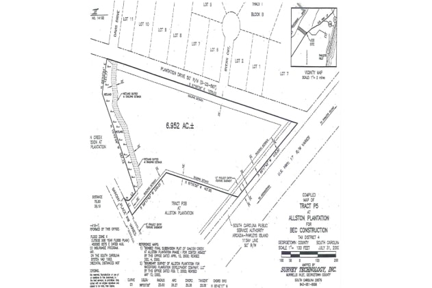
111 Old Plantation Dr
04-0418-007-00-00
Pico
Publicschool
US HWY 17 SLD 425-10,431-8,458-10,522-10, 535-1; SLD 763-10
X
Georgetown
45043C0366G
South Carolina
0
6.95 AC
2024
Myrtle Beach South
920504
Other Market Areas
28,708 SF
Murrells Inlet, SC
DEMOGRAPHICS near 111 Old Plantation Dr
1 Mile
3 Mile
5 Mile
2024 Total Population
1,868
8,202
16,198
2029 Population
1,944
8,740
17,256
Pop Growth 2024-2029
+ 4.07%
+ 6.56%
+ 6.53%
Average Age
52
53
52
2024 Total Households
791
3,688
7,251
HH Growth 2024-2029
+ 3.92%
+ 6.34%
+ 6.29%
Median Household Inc
$76,293
$83,394
$74,460
Avg Household Size
2.30
2.20
2.20
2024 Avg HH Vehicles
2.00
2.00
2.00
Median Home Value
$351,890
$373,626
$365,951
Median Year Built
1997
1997
1996
Nearby Places
Map Layers
Map Styles
 Street
 Aerial
- Restaurants
- Banks
- Shops
- Fitness
- Groceries
PUBLIC TRANSPORTATION
AIRPORT
Myrtle Beach International
DRIVE
WALK
Distance
Myrtle Beach International
42 min
27.6 mi
Freight Ports
Wando Welch Terminal
DRIVE
WALK
Distance
Wando Welch Terminal
85 min
63.6 mi
Nearby Properties
Address
Land Use
TOTAL SIZE
Lot Size
Zoning
Address
Land Use
TOTAL SIZE
Lot Size
Zoning
Address
Land Use
TOTAL SIZE
Lot Size
Zoning
19,489 SF
11.49 AC
Address
Land Use
TOTAL SIZE
Lot Size
Zoning
6,338 SF
0.78 AC
Address
Land Use
TOTAL SIZE
Lot Size
Zoning
Address
Land Use
TOTAL SIZE
Lot Size
Zoning
2.48 AC
Address
Land Use
TOTAL SIZE
Lot Size
Zoning
11,250 SF
4.39 AC
Address
Land Use
TOTAL SIZE
Lot Size
Zoning
Address
Land Use
TOTAL SIZE
Lot Size
Zoning
123,437 SF
12.01 AC
Address
Land Use
TOTAL SIZE
Lot Size
Zoning
4,802 SF
0.35 AC
Address
Land Use
TOTAL SIZE
Lot Size
Zoning
0.16 AC
Address
Land Use
TOTAL SIZE
Lot Size
Zoning
6,610 SF
1.07 AC
Address
Land Use
TOTAL SIZE
Lot Size
Zoning
0.42 AC
Address
Land Use
TOTAL SIZE
Lot Size
Zoning
3,699 SF
1 AC
Address
Land Use
TOTAL SIZE
Lot Size
Zoning
2,861 SF
0.56 AC
Address
Land Use
TOTAL SIZE
Lot Size
Zoning
2,748 SF
0.61 AC
Address
Land Use
TOTAL SIZE
Lot Size
Zoning
2,436 SF
0.13 AC
Address
Land Use
TOTAL SIZE
Lot Size
Zoning
6,427 SF
5.19 AC
Address
Land Use
TOTAL SIZE
Lot Size
Zoning
1,919 SF
1 AC
Address
Land Use
TOTAL SIZE
Lot Size
Zoning
4,280 SF
0.69 AC
Address
Land Use
TOTAL SIZE
Lot Size
Zoning
4,342 SF
4 AC
Address
Land Use
TOTAL SIZE
Lot Size
Zoning
4,076 SF
0.48 AC
Address
Land Use
TOTAL SIZE
Lot Size
Zoning
2,336 SF
0.14 AC
Address
Land Use
TOTAL SIZE
Lot Size
Zoning
2,652 SF
0.37 AC
Address
Land Use
TOTAL SIZE
Lot Size
Zoning
3,122 SF
0.69 AC
Address
Land Use
TOTAL SIZE
Lot Size
Zoning
2.37 AC
Address
Land Use
TOTAL SIZE
Lot Size
Zoning
2,520 SF
1.24 AC
Address
Land Use
TOTAL SIZE
Lot Size
Zoning
67,563 SF
12.75 AC
Address
Land Use
TOTAL SIZE
Lot Size
Zoning
2,636 SF
0.51 AC
Address
Land Use
TOTAL SIZE
Lot Size
Zoning
2,817 SF
0.49 AC
The World's #1 Commercial Real Estate Marketplace
Connect with us
© 2026 CoStar Group
The information above has been obtained from sources believed reliable. While we do not doubt its accuracy we have not verified it and make no guarantee, warranty or representation about it. It is your responsibility to independently confirm its accuracy and completeness. Any projections, opinions, assumptions, or estimates used are for example only and do not represent the current or future performance of the property. The value of this transaction to you depends on tax and other factors which should be evaluated by your tax, financial, and legal advisors. You and your advisors should conduct a careful, independent investigation of the property to determine to your satisfaction the suitability of the property for your needs.