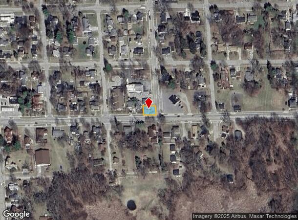
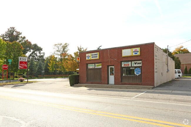
Property Record
111 Pearl St, Pinckney, MI 48169

NEARBY LISTINGS FOR SALE OR LEASE
Property Detail
111 Pearl St
14-23-302-050
Vil-Pinckney-Original Plat - Pinckney
Commercialnec
14-23-302-050 SEC 23 T1N R4E VILLAGE OF PINCKNEY ORIGINAL PLAT B 5-R 8 COM AT INTERSECTION OF W LINE OF PEARL ST & N LINE OF
X
Livingston
26093C0430D
Michigan
2025
0.07 AC
2025
Livingston County
733603
Detroit
1,800 SF
Detroit-Warren-Dearborn, MI
DEMOGRAPHICS near 111 Pearl St
1 Mile
3 Mile
5 Mile
2024 Total Population
2,753
10,854
24,118
2029 Population
2,796
11,128
24,685
Pop Growth 2024-2029
+ 1.56%
+ 2.52%
+ 2.35%
Average Age
41
45
45
2024 Total Households
1,044
4,285
9,480
HH Growth 2024-2029
+ 1.53%
+ 2.52%
+ 2.34%
Median Household Inc
$87,317
$95,287
$102,276
Avg Household Size
2.50
2.50
2.50
2024 Avg HH Vehicles
2.00
2.00
2.00
Median Home Value
$232,530
$320,517
$339,886
Median Year Built
1989
1985
1984
Nearby Places
Map Layers
Map Styles
 Street
 Aerial
- Restaurants
- Banks
- Shops
- Fitness
- Groceries
PUBLIC TRANSPORTATION
AIRPORT
Detroit Metro Wayne County
DRIVE
WALK
Distance
Detroit Metro Wayne County
65 min
47.3 mi
SALE & LEASE HISTORY
LISTING DATE
SALE/LEASE

Oct 13, 2016
For Sale
Nov 28, 2016
For Sale
Nearby Properties
Address
Land Use
TOTAL SIZE
Lot Size
Zoning
Address
Land Use
TOTAL SIZE
Lot Size
Zoning
13,200 SF
2.82 AC
VSBD
Address
Land Use
TOTAL SIZE
Lot Size
Zoning
76,188 SF
11.97 AC
VSBD
Address
Land Use
TOTAL SIZE
Lot Size
Zoning
47,516 SF
6.95 AC
VSBD
Address
Land Use
TOTAL SIZE
Lot Size
Zoning
395 AC
RR
Address
Land Use
TOTAL SIZE
Lot Size
Zoning
541.60 AC
PL
Address
Land Use
TOTAL SIZE
Lot Size
Zoning
38,400 SF
12.28 AC
C-2
Address
Land Use
TOTAL SIZE
Lot Size
Zoning
11,157 SF
4.95 AC
VSBD
Address
Land Use
TOTAL SIZE
Lot Size
Zoning
7,118 SF
80 AC
AO
Address
Land Use
TOTAL SIZE
Lot Size
Zoning
12,000 SF
3.03 AC
VSBD
Address
Land Use
TOTAL SIZE
Lot Size
Zoning
5,793 SF
2.89 AC
C-1
Address
Land Use
TOTAL SIZE
Lot Size
Zoning
6,000 SF
3.30 AC
C-2
Address
Land Use
TOTAL SIZE
Lot Size
Zoning
148 AC
AO
Address
Land Use
TOTAL SIZE
Lot Size
Zoning
17,296 SF
5 AC
C-2
Address
Land Use
TOTAL SIZE
Lot Size
Zoning
6,990 SF
37 AC
PUD
Address
Land Use
TOTAL SIZE
Lot Size
Zoning
12,760 SF
7.12 AC
VSBD
Address
Land Use
TOTAL SIZE
Lot Size
Zoning
5,896 SF
10 AC
AO
Address
Land Use
TOTAL SIZE
Lot Size
Zoning
21,915 SF
166.43 AC
RA
Address
Land Use
TOTAL SIZE
Lot Size
Zoning
2,340 SF
0.64 AC
VSBD
Address
Land Use
TOTAL SIZE
Lot Size
Zoning
78 AC
AO
Address
Land Use
TOTAL SIZE
Lot Size
Zoning
255.92 AC
AO
Address
Land Use
TOTAL SIZE
Lot Size
Zoning
2,350 SF
160 AC
AO
Address
Land Use
TOTAL SIZE
Lot Size
Zoning
0.33 AC
LR-1
Address
Land Use
TOTAL SIZE
Lot Size
Zoning
19,534 SF
8.23 AC
VR-3
Address
Land Use
TOTAL SIZE
Lot Size
Zoning
1,408 SF
108.32 AC
RR
Address
Land Use
TOTAL SIZE
Lot Size
Zoning
4,366 SF
80 AC
AO
Address
Land Use
TOTAL SIZE
Lot Size
Zoning
5,280 SF
0.80 AC
VSBD
Address
Land Use
TOTAL SIZE
Lot Size
Zoning
3,431 SF
2.13 AC
VSBD
Address
Land Use
TOTAL SIZE
Lot Size
Zoning
12,376 SF
6.10 AC
RR
Address
Land Use
TOTAL SIZE
Lot Size
Zoning
4,000 SF
0.68 AC
VR-4
Address
Land Use
TOTAL SIZE
Lot Size
Zoning
3,378 SF
1.19 AC
VSBD
The World's #1 Commercial Real Estate Marketplace
Connect with us
© 2026 CoStar Group
The information above has been obtained from sources believed reliable. While we do not doubt its accuracy we have not verified it and make no guarantee, warranty or representation about it. It is your responsibility to independently confirm its accuracy and completeness. Any projections, opinions, assumptions, or estimates used are for example only and do not represent the current or future performance of the property. The value of this transaction to you depends on tax and other factors which should be evaluated by your tax, financial, and legal advisors. You and your advisors should conduct a careful, independent investigation of the property to determine to your satisfaction the suitability of the property for your needs.