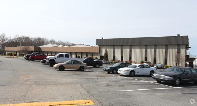
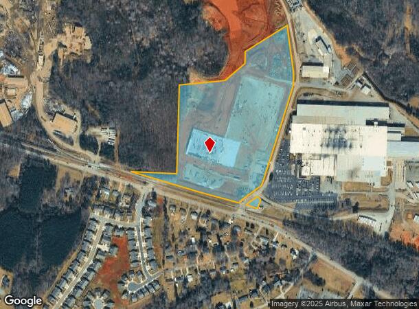
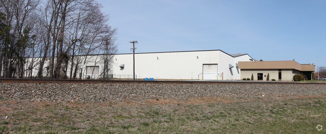
Property Record
111 Perry Rd, Kernersville, NC 27284
NEARBY LISTINGS FOR SALE OR LEASE
Property Detail
111 Perry Rd
Winston-Salem, NC
Omni Source
6877-60-4558
OMNI SOURCE LO:350 BL:5352 BU:1
Industrialacreage
Forsyth
X
North Carolina
3710687700J
350
2024
27.05 AC
2025
Kernersville
003107
Greensboro/Winston-Salem
2,625 SF
DEMOGRAPHICS near 111 Perry Rd
1 Mile
3 Mile
5 Mile
2024 Total Population
2,486
32,219
65,384
2029 Population
2,613
33,402
67,879
Pop Growth 2024-2029
+ 5.11%
+ 3.67%
+ 3.82%
Average Age
45
42
42
2024 Total Households
1,031
13,777
26,967
HH Growth 2024-2029
+ 5.14%
+ 3.67%
+ 3.85%
Median Household Inc
$106,413
$67,728
$72,205
Avg Household Size
2.40
2.30
2.40
2024 Avg HH Vehicles
2.00
2.00
2.00
Median Home Value
$296,249
$237,830
$227,388
Median Year Built
1992
1986
1989
Nearby Places
Map Layers
Map Styles
 Street
 Aerial
- Restaurants
- Banks
- Shops
- Fitness
- Groceries
PUBLIC TRANSPORTATION
AIRPORT
Piedmont Triad International
DRIVE
WALK
Distance
Piedmont Triad International
23 min
12.5 mi
Freight Ports
Virginia Port Authority - Richmond
DRIVE
WALK
Distance
Virginia Port Authority - Richmond
250 min
216.1 mi
Nearby Properties
Address
Land Use
TOTAL SIZE
Lot Size
Zoning
Address
Land Use
TOTAL SIZE
Lot Size
Zoning
73,908 SF
14.40 AC
GB-S
Address
Land Use
TOTAL SIZE
Lot Size
Zoning
77,879 SF
9.56 AC
GB-S
Address
Land Use
TOTAL SIZE
Lot Size
Zoning
576,252 SF
59.82 AC
GI,LI
Address
Land Use
TOTAL SIZE
Lot Size
Zoning
70,113 SF
19.06 AC
RM18-S
Address
Land Use
TOTAL SIZE
Lot Size
Zoning
115,838 SF
14.41 AC
GI-C
Address
Land Use
TOTAL SIZE
Lot Size
Zoning
129,895 SF
30.33 AC
RM18
Address
Land Use
TOTAL SIZE
Lot Size
Zoning
202,539 SF
23.70 AC
HB-S
Address
Land Use
TOTAL SIZE
Lot Size
Zoning
87,741 SF
15.44 AC
RM18
Address
Land Use
TOTAL SIZE
Lot Size
Zoning
545,857 SF
51.60 AC
GI
Address
Land Use
TOTAL SIZE
Lot Size
Zoning
78,274 SF
27.95 AC
RM8-S
Address
Land Use
TOTAL SIZE
Lot Size
Zoning
451.32 AC
MU-C
Address
Land Use
TOTAL SIZE
Lot Size
Zoning
277,250 SF
30.15 AC
GI
Address
Land Use
TOTAL SIZE
Lot Size
Zoning
136,068 SF
19.46 AC
HB-S
Address
Land Use
TOTAL SIZE
Lot Size
Zoning
121,981 SF
14.48 AC
HB-S
Address
Land Use
TOTAL SIZE
Lot Size
Zoning
83,774 SF
7.51 AC
GB-S
Address
Land Use
TOTAL SIZE
Lot Size
Zoning
83,027 SF
14.47 AC
HB-S,LO-S
Address
Land Use
TOTAL SIZE
Lot Size
Zoning
98,617 SF
37.44 AC
RS20
Address
Land Use
TOTAL SIZE
Lot Size
Zoning
160,179 SF
23.75 AC
LI-C,RS20
Address
Land Use
TOTAL SIZE
Lot Size
Zoning
603,494 SF
48.87 AC
LI
Address
Land Use
TOTAL SIZE
Lot Size
Zoning
122,682 SF
9.07 AC
HB-S
Address
Land Use
TOTAL SIZE
Lot Size
Zoning
102,809 SF
16.74 AC
BI
Address
Land Use
TOTAL SIZE
Lot Size
Zoning
43,286 SF
3.77 AC
RMU-S
Address
Land Use
TOTAL SIZE
Lot Size
Zoning
94,092 SF
15.31 AC
RM18
Address
Land Use
TOTAL SIZE
Lot Size
Zoning
52,480 SF
30.51 AC
BI
Address
Land Use
TOTAL SIZE
Lot Size
Zoning
93,437 SF
11.59 AC
HB-S
Address
Land Use
TOTAL SIZE
Lot Size
Zoning
102,950 SF
21.98 AC
RS12
Address
Land Use
TOTAL SIZE
Lot Size
Zoning
71,538 SF
9.02 AC
IP
Address
Land Use
TOTAL SIZE
Lot Size
Zoning
52,792 SF
25.21 AC
BI
Address
Land Use
TOTAL SIZE
Lot Size
Zoning
197,805 SF
11.99 AC
GI-S
Address
Land Use
TOTAL SIZE
Lot Size
Zoning
216,910 SF
8.49 AC
GI-S
The World's #1 Commercial Real Estate Marketplace
Connect with us
© 2026 CoStar Group
The information above has been obtained from sources believed reliable. While we do not doubt its accuracy we have not verified it and make no guarantee, warranty or representation about it. It is your responsibility to independently confirm its accuracy and completeness. Any projections, opinions, assumptions, or estimates used are for example only and do not represent the current or future performance of the property. The value of this transaction to you depends on tax and other factors which should be evaluated by your tax, financial, and legal advisors. You and your advisors should conduct a careful, independent investigation of the property to determine to your satisfaction the suitability of the property for your needs.