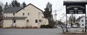
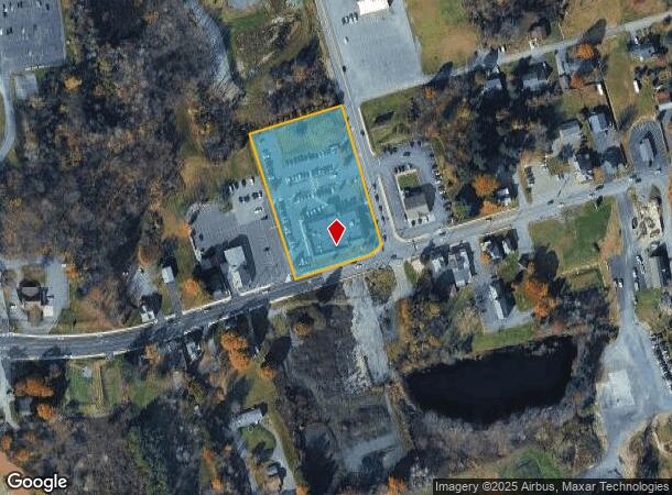
Property Record
111 Route 715, Brodheadsville, PA 18322
NEARBY LISTINGS FOR SALE OR LEASE
Property Detail
111 Route 715
02.3.1.33
Wide Private Alley
Medicalbuilding
Monroe
X
Pennsylvania
42089C0395E
2.32 AC
2025
Monroe County
2025
Philadelphia
301202
East Stroudsburg, PA
14,677 SF
DEMOGRAPHICS near 111 Route 715
1 Mile
3 Mile
5 Mile
2024 Total Population
1,136
9,923
24,644
2029 Population
1,126
9,969
24,695
Pop Growth 2024-2029
(0.88%)
+ 0.46%
+ 0.21%
Average Age
44
44
44
2024 Total Households
427
3,640
9,122
HH Growth 2024-2029
(0.70%)
+ 0.47%
+ 0.19%
Median Household Inc
$95,535
$89,362
$84,490
Avg Household Size
2.60
2.70
2.60
2024 Avg HH Vehicles
2.00
2.00
2.00
Median Home Value
$244,239
$243,322
$240,265
Median Year Built
1979
1984
1985
Nearby Places
Map Layers
Map Styles
 Street
 Aerial
- Restaurants
- Banks
- Shops
- Fitness
- Groceries
PUBLIC TRANSPORTATION
AIRPORT
Lehigh Valley International
DRIVE
WALK
Distance
Lehigh Valley International
45 min
30.7 mi
Wilkes-Barre/Scranton International
DRIVE
WALK
Distance
Wilkes-Barre/Scranton International
66 min
47.1 mi
Nearby Properties
Address
Land Use
TOTAL SIZE
Lot Size
Zoning
Address
Land Use
TOTAL SIZE
Lot Size
Zoning
121,926 SF
108.01 AC
I
Address
Land Use
TOTAL SIZE
Lot Size
Zoning
176,289 SF
17.19 AC
Address
Land Use
TOTAL SIZE
Lot Size
Zoning
121,312 SF
26.29 AC
LIC
Address
Land Use
TOTAL SIZE
Lot Size
Zoning
89,411 SF
9 AC
C1
Address
Land Use
TOTAL SIZE
Lot Size
Zoning
66,849 SF
9.08 AC
GC
Address
Land Use
TOTAL SIZE
Lot Size
Zoning
29,928 SF
5.19 AC
VC
Address
Land Use
TOTAL SIZE
Lot Size
Zoning
33,470 SF
12.91 AC
LIC
Address
Land Use
TOTAL SIZE
Lot Size
Zoning
27,510 SF
1.15 AC
GC
Address
Land Use
TOTAL SIZE
Lot Size
Zoning
18,900 SF
4.57 AC
GC
Address
Land Use
TOTAL SIZE
Lot Size
Zoning
3,000 SF
6.17 AC
C
Address
Land Use
TOTAL SIZE
Lot Size
Zoning
21,000 SF
7.54 AC
GC
Address
Land Use
TOTAL SIZE
Lot Size
Zoning
10,166 SF
1.70 AC
GC
Address
Land Use
TOTAL SIZE
Lot Size
Zoning
2,918 SF
3.20 AC
VC
Address
Land Use
TOTAL SIZE
Lot Size
Zoning
14,520 SF
10.70 AC
RR
Address
Land Use
TOTAL SIZE
Lot Size
Zoning
29,836 SF
4.15 AC
GC
Address
Land Use
TOTAL SIZE
Lot Size
Zoning
32,139 SF
3.20 AC
VC
Address
Land Use
TOTAL SIZE
Lot Size
Zoning
1,380 SF
4.41 AC
GC
Address
Land Use
TOTAL SIZE
Lot Size
Zoning
9,600 SF
1.50 AC
GC
Address
Land Use
TOTAL SIZE
Lot Size
Zoning
4,596 SF
3.37 AC
GC
Address
Land Use
TOTAL SIZE
Lot Size
Zoning
11,200 SF
2.14 AC
GC
Address
Land Use
TOTAL SIZE
Lot Size
Zoning
15,609 SF
3.14 AC
GC
Address
Land Use
TOTAL SIZE
Lot Size
Zoning
9,275 SF
11.73 AC
GC
Address
Land Use
TOTAL SIZE
Lot Size
Zoning
29,193 SF
10.77 AC
GC
Address
Land Use
TOTAL SIZE
Lot Size
Zoning
4,048 SF
2.35 AC
VC
Address
Land Use
TOTAL SIZE
Lot Size
Zoning
11,598 SF
2.62 AC
GC
Address
Land Use
TOTAL SIZE
Lot Size
Zoning
7,000 SF
1.26 AC
GC
Address
Land Use
TOTAL SIZE
Lot Size
Zoning
18,382 SF
15.77 AC
GC
Address
Land Use
TOTAL SIZE
Lot Size
Zoning
9,968 SF
7.23 AC
GC
Address
Land Use
TOTAL SIZE
Lot Size
Zoning
17,742 SF
2.16 AC
GC
The World's #1 Commercial Real Estate Marketplace
Connect with us
© 2025 CoStar Group
The information above has been obtained from sources believed reliable. While we do not doubt its accuracy we have not verified it and make no guarantee, warranty or representation about it. It is your responsibility to independently confirm its accuracy and completeness. Any projections, opinions, assumptions, or estimates used are for example only and do not represent the current or future performance of the property. The value of this transaction to you depends on tax and other factors which should be evaluated by your tax, financial, and legal advisors. You and your advisors should conduct a careful, independent investigation of the property to determine to your satisfaction the suitability of the property for your needs.