Property Record
111 Veterans Memorial Blvd, Metairie, LA 70005

Current Lease Availabilities
NEARBY LISTINGS FOR SALE OR LEASE
Property Detail
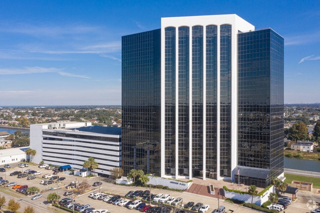
111 Veterans Memorial Blvd
New Orleans-Metairie, LA
Metairieville Sqs
0820028915
METAIRIEVILLE 10060976 10215685
Miscpropertynotclassed
Jefferson
X
Louisiana
22051C0140F
a
2024
3.55 AC
2024
Metairie
028700
New Orleans/Metairie/Kenner
DEMOGRAPHICS near 111 Veterans Memorial Blvd
1 Mile
3 Mile
5 Mile
2024 Total Population
19,644
115,317
300,925
2029 Population
18,818
110,566
289,672
Pop Growth 2024-2029
(4.20%)
(4.12%)
(3.74%)
Average Age
42
42
41
2024 Total Households
8,916
52,357
134,622
HH Growth 2024-2029
(4.24%)
(4.25%)
(3.76%)
Median Household Inc
$74,717
$64,363
$54,731
Avg Household Size
2.20
2.10
2.10
2024 Avg HH Vehicles
2.00
1.00
1.00
Median Home Value
$361,246
$360,757
$317,866
Median Year Built
1968
1964
1959
Nearby Places
Map Layers
Map Styles
 Street
 Aerial
- Restaurants
- Banks
- Shops
- Fitness
- Groceries
PUBLIC TRANSPORTATION
COMMUTER RAIL
New Orleans Union Passenger Terminal (City of New Orleans - Amtrak, Crescent - Amtrak, Sunset Limited - Amtrak)
DRIVE
WALK
Distance
New Orleans Union Passenger Terminal (City of New Orleans - Amtrak, Crescent - Amtrak, Sunset Limited - Amtrak)
9 min
5.8 mi
AIRPORT
Louis Armstrong New Orleans International
DRIVE
WALK
Distance
Louis Armstrong New Orleans International
17 min
10.3 mi
Freight Ports
Port of New Orleans
DRIVE
WALK
Distance
Port of New Orleans
15 min
7.8 mi
Nearby Properties
Address
Land Use
TOTAL SIZE
Lot Size
Zoning
Address
Land Use
TOTAL SIZE
Lot Size
Zoning
22.63 AC
Address
Land Use
TOTAL SIZE
Lot Size
Zoning
50.06 AC
R1A
Address
Land Use
TOTAL SIZE
Lot Size
Zoning
725,677 SF
54.19 AC
EC
Address
Land Use
TOTAL SIZE
Lot Size
Zoning
225,284 SF
16.83 AC
S-RD
Address
Land Use
TOTAL SIZE
Lot Size
Zoning
35.06 AC
Address
Land Use
TOTAL SIZE
Lot Size
Zoning
4.31 AC
BC2
Address
Land Use
TOTAL SIZE
Lot Size
Zoning
224,374 SF
92.67 AC
HU-RD1
Address
Land Use
TOTAL SIZE
Lot Size
Zoning
7.56 AC
S-LRS1
Address
Land Use
TOTAL SIZE
Lot Size
Zoning
1.45 AC
M1
Address
Land Use
TOTAL SIZE
Lot Size
Zoning
2.20 AC
EC
Address
Land Use
TOTAL SIZE
Lot Size
Zoning
63.72 AC
OS-N
Address
Land Use
TOTAL SIZE
Lot Size
Zoning
3.32 AC
FC3
Address
Land Use
TOTAL SIZE
Lot Size
Zoning
14.83 AC
EC
Address
Land Use
TOTAL SIZE
Lot Size
Zoning
66.97 AC
LI
Address
Land Use
TOTAL SIZE
Lot Size
Zoning
Address
Land Use
TOTAL SIZE
Lot Size
Zoning
Address
Land Use
TOTAL SIZE
Lot Size
Zoning
20.49 AC
S-RS
Address
Land Use
TOTAL SIZE
Lot Size
Zoning
Address
Land Use
TOTAL SIZE
Lot Size
Zoning
Address
Land Use
TOTAL SIZE
Lot Size
Zoning
98,642 SF
7.30 AC
HU-RS
Address
Land Use
TOTAL SIZE
Lot Size
Zoning
2.56 AC
R2
Address
Land Use
TOTAL SIZE
Lot Size
Zoning
108,104 SF
8.98 AC
S-LRS1
Address
Land Use
TOTAL SIZE
Lot Size
Zoning
39,963 SF
110.36 AC
OS-N
Address
Land Use
TOTAL SIZE
Lot Size
Zoning
4.90 AC
R2
Address
Land Use
TOTAL SIZE
Lot Size
Zoning
13,496 SF
3.01 AC
HU-RD2
Address
Land Use
TOTAL SIZE
Lot Size
Zoning
2.27 AC
HU-RD2
Address
Land Use
TOTAL SIZE
Lot Size
Zoning
114,454 SF
3.05 AC
MU-1
Address
Land Use
TOTAL SIZE
Lot Size
Zoning
0.12 AC
The World's #1 Commercial Real Estate Marketplace
Connect with us
© 2026 CoStar Group
The information above has been obtained from sources believed reliable. While we do not doubt its accuracy we have not verified it and make no guarantee, warranty or representation about it. It is your responsibility to independently confirm its accuracy and completeness. Any projections, opinions, assumptions, or estimates used are for example only and do not represent the current or future performance of the property. The value of this transaction to you depends on tax and other factors which should be evaluated by your tax, financial, and legal advisors. You and your advisors should conduct a careful, independent investigation of the property to determine to your satisfaction the suitability of the property for your needs.