Property Record
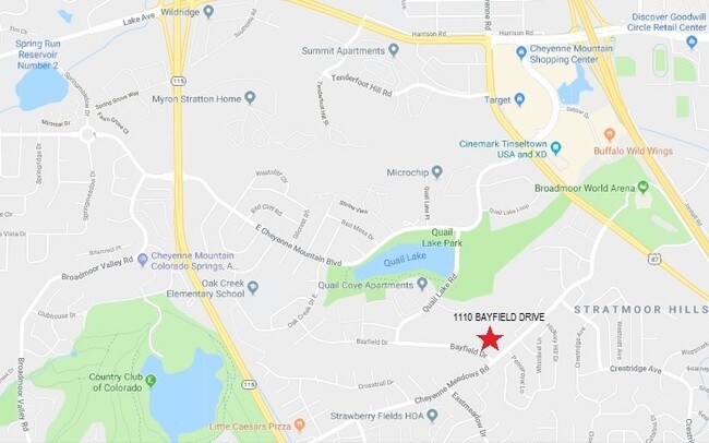
1110 Bayfield Dr, Colorado Springs, CO 80906

NEARBY LISTINGS FOR SALE OR LEASE
Property Detail
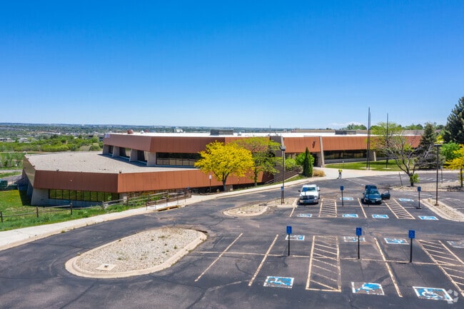
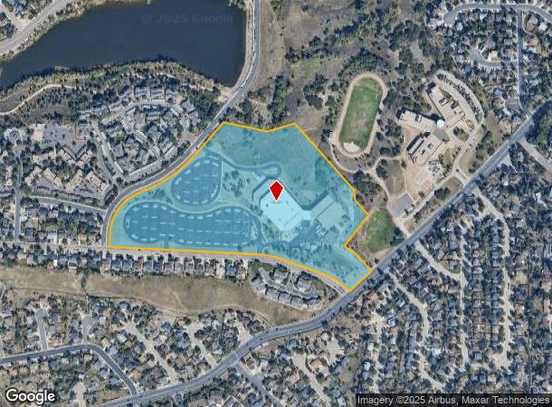
1110 Bayfield Dr
Colorado Springs, CO
Quail Lake Campus Center Fil No 8
64323-07-002
LOT 1 QUAIL LAKE CAMPUS CENTER FIL NO 8
Officebuilding
El Paso
X
Colorado
08041C0741G
1
2024
26.35 AC
2025
Southwest
003307
Colorado Springs
166,182 SF
DEMOGRAPHICS near 1110 Bayfield Dr
1 Mile
3 Mile
5 Mile
2024 Total Population
13,549
81,564
205,235
2029 Population
14,161
85,402
214,742
Pop Growth 2024-2029
+ 4.52%
+ 4.71%
+ 4.63%
Average Age
37
37
36
2024 Total Households
6,064
31,802
79,072
HH Growth 2024-2029
+ 4.77%
+ 5.04%
+ 5.01%
Median Household Inc
$63,895
$60,578
$59,954
Avg Household Size
2.20
2.40
2.40
2024 Avg HH Vehicles
2.00
2.00
2.00
Median Home Value
$364,148
$370,033
$334,823
Median Year Built
1986
1980
1980
Nearby Places
Map Layers
Map Styles
 Street
 Aerial
- Restaurants
- Banks
- Shops
- Fitness
- Groceries
PUBLIC TRANSPORTATION
AIRPORT
City of Colorado Springs Municipal
DRIVE
WALK
Distance
City of Colorado Springs Municipal
22 min
10.4 mi
Freight Ports
Tulsa Port Of Catoosa
DRIVE
WALK
Distance
Tulsa Port Of Catoosa
748 min
697.1 mi
SALE & LEASE HISTORY
LISTING DATE
SALE/LEASE

Jul 11, 2019
For Lease
Feb 04, 2020
For Lease
Dec 22, 2018
For Lease
Nearby Properties
Address
Land Use
TOTAL SIZE
Lot Size
Zoning
Address
Land Use
TOTAL SIZE
Lot Size
Zoning
309,046 SF
28.95 AC
PF SS
Address
Land Use
TOTAL SIZE
Lot Size
Zoning
215,464 SF
11.59 AC
R-5
Address
Land Use
TOTAL SIZE
Lot Size
Zoning
152,977 SF
39.50 AC
MX-M MX-M/
Address
Land Use
TOTAL SIZE
Lot Size
Zoning
168,835 SF
33 AC
PF SS
Address
Land Use
TOTAL SIZE
Lot Size
Zoning
215,377 SF
11.24 AC
R-5/CR
Address
Land Use
TOTAL SIZE
Lot Size
Zoning
983,639 SF
43.31 AC
MX-M CU HR
Address
Land Use
TOTAL SIZE
Lot Size
Zoning
123,644 SF
74.14 AC
GI PF SS
Address
Land Use
TOTAL SIZE
Lot Size
Zoning
113,594 SF
1.65 AC
R-5 HR
Address
Land Use
TOTAL SIZE
Lot Size
Zoning
49,031 SF
69.16 AC
PCR HS
Address
Land Use
TOTAL SIZE
Lot Size
Zoning
71,438 SF
9.81 AC
R-5/CR
Address
Land Use
TOTAL SIZE
Lot Size
Zoning
47,870 SF
0.72 AC
FBZ-COR SS
Address
Land Use
TOTAL SIZE
Lot Size
Zoning
601,737 SF
7.24 AC
MX-M
Address
Land Use
TOTAL SIZE
Lot Size
Zoning
64,870 SF
0.92 AC
PDZ UV
Address
Land Use
TOTAL SIZE
Lot Size
Zoning
99,829 SF
15.39 AC
R-E CU UV
Address
Land Use
TOTAL SIZE
Lot Size
Zoning
107,146 SF
16.72 AC
R-1 6 CU
Address
Land Use
TOTAL SIZE
Lot Size
Zoning
58,598 SF
0.96 AC
PDZ UV
Address
Land Use
TOTAL SIZE
Lot Size
Zoning
124,107 SF
104.60 AC
MX-N CU
Address
Land Use
TOTAL SIZE
Lot Size
Zoning
24,293 SF
10.61 AC
C5
Address
Land Use
TOTAL SIZE
Lot Size
Zoning
76,047 SF
5.74 AC
PF
Address
Land Use
TOTAL SIZE
Lot Size
Zoning
46,190 SF
4.02 AC
PDZ
Address
Land Use
TOTAL SIZE
Lot Size
Zoning
66,036 SF
6.70 AC
R-1 6 HS U
Address
Land Use
TOTAL SIZE
Lot Size
Zoning
38,365 SF
3.37 AC
MX-M
Address
Land Use
TOTAL SIZE
Lot Size
Zoning
107,610 SF
5.69 AC
R-E
Address
Land Use
TOTAL SIZE
Lot Size
Zoning
261,184 SF
17.39 AC
MX-M CU
Address
Land Use
TOTAL SIZE
Lot Size
Zoning
46,766 SF
0.84 AC
PDZ UV
Address
Land Use
TOTAL SIZE
Lot Size
Zoning
118,700 SF
22.90 AC
R-1 6 AO
Address
Land Use
TOTAL SIZE
Lot Size
Zoning
28,769 SF
3.92 AC
MX-M
Address
Land Use
TOTAL SIZE
Lot Size
Zoning
43,052 SF
2.06 AC
PDZ
Address
Land Use
TOTAL SIZE
Lot Size
Zoning
60,730 SF
4.26 AC
BP
The World's #1 Commercial Real Estate Marketplace
Connect with us
© 2026 CoStar Group
The information above has been obtained from sources believed reliable. While we do not doubt its accuracy we have not verified it and make no guarantee, warranty or representation about it. It is your responsibility to independently confirm its accuracy and completeness. Any projections, opinions, assumptions, or estimates used are for example only and do not represent the current or future performance of the property. The value of this transaction to you depends on tax and other factors which should be evaluated by your tax, financial, and legal advisors. You and your advisors should conduct a careful, independent investigation of the property to determine to your satisfaction the suitability of the property for your needs.