Property Record
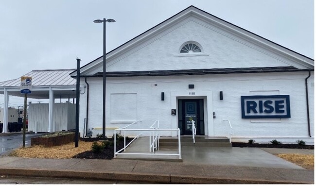
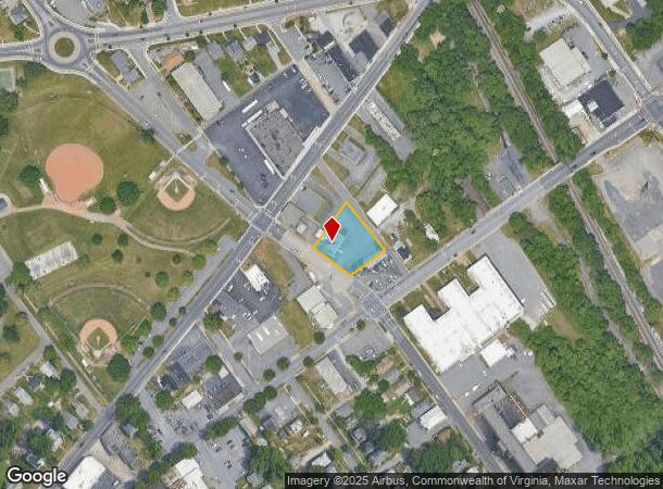
1110 Campbell Ave, Lynchburg, VA 24501
This Property Is For Sale
NEARBY LISTINGS FOR SALE OR LEASE
Property Detail
1110 Campbell Ave
027-08-002
Commercial Misc
Storebuilding
HUNTER, MOORE, JAMERSON, PARCEL 2
X
Lynchburg City
51009C0395C
Virginia
2025
0.50 AC
2025
Lynchburg
000700
Other Market Areas
2,226 SF
Lynchburg, VA
DEMOGRAPHICS near 1110 Campbell Ave
1 Mile
3 Mile
5 Mile
2024 Total Population
9,057
42,436
75,392
2029 Population
9,157
42,661
75,838
Pop Growth 2024-2029
+ 1.10%
+ 0.53%
+ 0.59%
Average Age
36
36
37
2024 Total Households
3,672
17,302
31,040
HH Growth 2024-2029
+ 1.14%
+ 0.57%
+ 0.63%
Median Household Inc
$36,962
$46,744
$53,109
Avg Household Size
2.20
2.20
2.20
2024 Avg HH Vehicles
1.00
2.00
2.00
Median Home Value
$82,790
$142,429
$169,464
Median Year Built
1949
1956
1967
Nearby Places
- Restaurants
- Banks
- Shops
- Fitness
- Groceries
PUBLIC TRANSPORTATION
COMMUTER RAIL
Lynchburg (Crescent - Amtrak, Northeast Regional - Amtrak)
DRIVE
WALK
Distance
Lynchburg (Crescent - Amtrak, Northeast Regional - Amtrak)
0 min
5 min
0.3 mi
AIRPORT
Lynchburg Regional/Preston Glenn Field
DRIVE
WALK
Distance
Lynchburg Regional/Preston Glenn Field
14 min
8.7 mi
Freight Ports
Virginia Port Authority - Richmond
DRIVE
WALK
Distance
Virginia Port Authority - Richmond
151 min
111.4 mi
Nearby Properties
Address
Land Use
TOTAL SIZE
Lot Size
Zoning
Address
Land Use
TOTAL SIZE
Lot Size
Zoning
686,112 SF
29.65 AC
B1R2
Address
Land Use
TOTAL SIZE
Lot Size
Zoning
814,428 SF
99.03 AC
212923
Address
Land Use
TOTAL SIZE
Lot Size
Zoning
516,183 SF
16.46 AC
R1
Address
Land Use
TOTAL SIZE
Lot Size
Zoning
626,329 SF
50.88 AC
2521
Address
Land Use
TOTAL SIZE
Lot Size
Zoning
323,985 SF
50.89 AC
2305
Address
Land Use
TOTAL SIZE
Lot Size
Zoning
400,209 SF
26.87 AC
B5
Address
Land Use
TOTAL SIZE
Lot Size
Zoning
Address
Land Use
TOTAL SIZE
Lot Size
Zoning
1,200 SF
73.13 AC
Address
Land Use
TOTAL SIZE
Lot Size
Zoning
183,584 SF
2 AC
R4
Address
Land Use
TOTAL SIZE
Lot Size
Zoning
8,259 SF
13.02 AC
Address
Land Use
TOTAL SIZE
Lot Size
Zoning
181,808 SF
39.61 AC
192921
Address
Land Use
TOTAL SIZE
Lot Size
Zoning
387,080 SF
18.30 AC
1509
Address
Land Use
TOTAL SIZE
Lot Size
Zoning
284,151 SF
70.13 AC
I3
Address
Land Use
TOTAL SIZE
Lot Size
Zoning
86,855 SF
10.68 AC
B1
Address
Land Use
TOTAL SIZE
Lot Size
Zoning
10.13 AC
R4RC
Address
Land Use
TOTAL SIZE
Lot Size
Zoning
267,447 SF
28.46 AC
B3
Address
Land Use
TOTAL SIZE
Lot Size
Zoning
68,240 SF
20.56 AC
R4
Address
Land Use
TOTAL SIZE
Lot Size
Zoning
103,515 SF
25.04 AC
B5R1
Address
Land Use
TOTAL SIZE
Lot Size
Zoning
91,070 SF
9.80 AC
B3
Address
Land Use
TOTAL SIZE
Lot Size
Zoning
290,213 SF
14.93 AC
I3
Address
Land Use
TOTAL SIZE
Lot Size
Zoning
118,789 SF
1.90 AC
2501
Address
Land Use
TOTAL SIZE
Lot Size
Zoning
3.67 AC
I3RC
Address
Land Use
TOTAL SIZE
Lot Size
Zoning
114,738 SF
0.51 AC
B4
Address
Land Use
TOTAL SIZE
Lot Size
Zoning
186,273 SF
35 AC
R1RC
Address
Land Use
TOTAL SIZE
Lot Size
Zoning
185,130 SF
32.87 AC
B3
Address
Land Use
TOTAL SIZE
Lot Size
Zoning
46,689 SF
1.74 AC
B6
Address
Land Use
TOTAL SIZE
Lot Size
Zoning
33,027 SF
15.02 AC
B5
Address
Land Use
TOTAL SIZE
Lot Size
Zoning
112,800 SF
11.23 AC
B5
Address
Land Use
TOTAL SIZE
Lot Size
Zoning
212,795 SF
31.49 AC
1505
Address
Land Use
TOTAL SIZE
Lot Size
Zoning
53,907 SF
10.38 AC
R3
The World's #1 Commercial Real Estate Marketplace
Connect with us
© 2025 CoStar Group
The information above has been obtained from sources believed reliable. While we do not doubt its accuracy we have not verified it and make no guarantee, warranty or representation about it. It is your responsibility to independently confirm its accuracy and completeness. Any projections, opinions, assumptions, or estimates used are for example only and do not represent the current or future performance of the property. The value of this transaction to you depends on tax and other factors which should be evaluated by your tax, financial, and legal advisors. You and your advisors should conduct a careful, independent investigation of the property to determine to your satisfaction the suitability of the property for your needs.