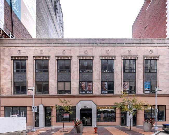
Property Record
1104 Euclid Ave, Cleveland, OH 44115
Current Lease Availabilities
NEARBY LISTINGS FOR SALE OR LEASE
Property Detail
1104 Euclid Ave
101-36-017
156 WP 240 FT W OF E 12 ST 10136018
Officebuilding
Cuyahoga
X
Ohio
39035C0068F
156
2024
0.24 AC
2024
CBD
107701
Cleveland
41,424 SF
Cleveland-Elyria, OH
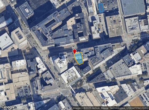
DEMOGRAPHICS near 1104 Euclid Ave
1 Mile
3 Mile
5 Mile
2024 Total Population
18,844
80,810
241,299
2029 Population
19,132
79,857
236,743
Pop Growth 2024-2029
+ 1.53%
(1.18%)
(1.89%)
Average Age
34
37
38
2024 Total Households
10,678
39,456
111,964
HH Growth 2024-2029
+ 2.46%
(0.82%)
(1.76%)
Median Household Inc
$54,995
$37,215
$34,630
Avg Household Size
1.50
1.90
2.00
2024 Avg HH Vehicles
1.00
1.00
1.00
Median Home Value
$345,625
$161,774
$92,720
Median Year Built
1969
1948
1947
Nearby Places
Map Layers
Map Styles
 Street
 Aerial
- Restaurants
- Banks
- Shops
- Fitness
- Groceries
PUBLIC TRANSPORTATION
TRANSIT/SUBWAY
Tower City - Public Square (Blue Line - Greater Cleveland Regional Transit Authority Rapid Transit (The Rapid), Green Line - Greater Cleveland Regional Transit Authority Rapid Transit (The Rapid), Red Line - Greater Cleveland Regional Transit Authority Rapid Transit (The Rapid))
DRIVE
WALK
Distance
Tower City - Public Square (Blue Line - Greater Cleveland Regional Transit Authority Rapid Transit (The Rapid), Green Line - Greater Cleveland Regional Transit Authority Rapid Transit (The Rapid), Red Line - Greater Cleveland Regional Transit Authority Rapid Transit (The Rapid))
2 min
10 min
0.5 mi
Cleveland Lakefront Station (Blue Line - Greater Cleveland Regional Transit Authority Rapid Transit (The Rapid), Green Line - Greater Cleveland Regional Transit Authority Rapid Transit (The Rapid))
DRIVE
WALK
Distance
Cleveland Lakefront Station (Blue Line - Greater Cleveland Regional Transit Authority Rapid Transit (The Rapid), Green Line - Greater Cleveland Regional Transit Authority Rapid Transit (The Rapid))
8 min
17 min
0.9 mi
COMMUTER RAIL
Cleveland Lakefront Station (Blue Line - Greater Cleveland Regional Transit Authority Rapid Transit (The Rapid), Green Line - Greater Cleveland Regional Transit Authority Rapid Transit (The Rapid))
DRIVE
WALK
Distance
Cleveland Lakefront Station (Blue Line - Greater Cleveland Regional Transit Authority Rapid Transit (The Rapid), Green Line - Greater Cleveland Regional Transit Authority Rapid Transit (The Rapid))
7 min
17 min
0.9 mi
DRIVE
WALK
Distance
16 min
9.3 mi
AIRPORT
Cleveland-Hopkins International
DRIVE
WALK
Distance
Cleveland-Hopkins International
20 min
13.9 mi
Nearby Properties
Address
Land Use
TOTAL SIZE
Lot Size
Zoning
Address
Land Use
TOTAL SIZE
Lot Size
Zoning
3,491,901 SF
34.32 AC
Address
Land Use
TOTAL SIZE
Lot Size
Zoning
753,970 SF
9.31 AC
GR
Address
Land Use
TOTAL SIZE
Lot Size
Zoning
1,570,958 SF
1.33 AC
GR
Address
Land Use
TOTAL SIZE
Lot Size
Zoning
17.45 AC
GI
Address
Land Use
TOTAL SIZE
Lot Size
Zoning
16.78 AC
SI
Address
Land Use
TOTAL SIZE
Lot Size
Zoning
710,780 SF
4.33 AC
GR
Address
Land Use
TOTAL SIZE
Lot Size
Zoning
765,607 SF
12.15 AC
GR
Address
Land Use
TOTAL SIZE
Lot Size
Zoning
788,580 SF
4.85 AC
GR
Address
Land Use
TOTAL SIZE
Lot Size
Zoning
434,475 SF
0.53 AC
Address
Land Use
TOTAL SIZE
Lot Size
Zoning
1,191,268 SF
3.94 AC
SI
Address
Land Use
TOTAL SIZE
Lot Size
Zoning
6.98 AC
SI
Address
Land Use
TOTAL SIZE
Lot Size
Zoning
148,486 SF
489.21 AC
GI
Address
Land Use
TOTAL SIZE
Lot Size
Zoning
5,100 SF
9.41 AC
GI
Address
Land Use
TOTAL SIZE
Lot Size
Zoning
652,455 SF
2.04 AC
GR
Address
Land Use
TOTAL SIZE
Lot Size
Zoning
263,723 SF
7.48 AC
GI
Address
Land Use
TOTAL SIZE
Lot Size
Zoning
1,130,924 SF
4.02 AC
SI
Address
Land Use
TOTAL SIZE
Lot Size
Zoning
299,515 SF
1.30 AC
GR
Address
Land Use
TOTAL SIZE
Lot Size
Zoning
1,181,536 SF
27.82 AC
RO
Address
Land Use
TOTAL SIZE
Lot Size
Zoning
228,154 SF
0.48 AC
GR
Address
Land Use
TOTAL SIZE
Lot Size
Zoning
3.23 AC
LLR
Address
Land Use
TOTAL SIZE
Lot Size
Zoning
2.74 AC
Address
Land Use
TOTAL SIZE
Lot Size
Zoning
1,003,787 SF
2.12 AC
GR
Address
Land Use
TOTAL SIZE
Lot Size
Zoning
1,467,599 SF
1.66 AC
GR
Address
Land Use
TOTAL SIZE
Lot Size
Zoning
758,394 SF
2.25 AC
GR
Address
Land Use
TOTAL SIZE
Lot Size
Zoning
493,911 SF
1.88 AC
LLR
Address
Land Use
TOTAL SIZE
Lot Size
Zoning
257,857 SF
8.03 AC
GR
Address
Land Use
TOTAL SIZE
Lot Size
Zoning
1.53 AC
LLR
Address
Land Use
TOTAL SIZE
Lot Size
Zoning
299,507 SF
2.14 AC
LR
Address
Land Use
TOTAL SIZE
Lot Size
Zoning
194,478 SF
9.61 AC
SI
Address
Land Use
TOTAL SIZE
Lot Size
Zoning
2.83 AC
LLR
The World's #1 Commercial Real Estate Marketplace
Connect with us
© 2025 CoStar Group
The information above has been obtained from sources believed reliable. While we do not doubt its accuracy we have not verified it and make no guarantee, warranty or representation about it. It is your responsibility to independently confirm its accuracy and completeness. Any projections, opinions, assumptions, or estimates used are for example only and do not represent the current or future performance of the property. The value of this transaction to you depends on tax and other factors which should be evaluated by your tax, financial, and legal advisors. You and your advisors should conduct a careful, independent investigation of the property to determine to your satisfaction the suitability of the property for your needs.