Property Record
1110 Laurel Hill Rd, Mc Donald, PA 15057
NEARBY LISTINGS FOR SALE OR LEASE
Property Detail
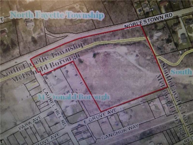
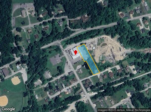
1110 Laurel Hill Rd
Pittsburgh, PA
LOT 80X380
0683-G-00351-0000-00
Allegheny
Vehiclerentalsvehiclesales
Pennsylvania
AE
351
42125C0176E
0.70 AC
2024
South Pittsburgh/I-79
2025
Pittsburgh
564000
DEMOGRAPHICS near 1110 Laurel Hill Rd
1 Mile
3 Mile
5 Mile
2024 Total Population
3,372
12,686
35,999
2029 Population
3,364
12,554
35,774
Pop Growth 2024-2029
(0.24%)
(1.04%)
(0.63%)
Average Age
43
40
41
2024 Total Households
1,486
4,880
13,811
HH Growth 2024-2029
(0.13%)
(0.96%)
(0.62%)
Median Household Inc
$64,782
$95,885
$99,395
Avg Household Size
2.30
2.60
2.50
2024 Avg HH Vehicles
2.00
2.00
2.00
Median Home Value
$168,616
$266,610
$271,849
Median Year Built
1948
1969
1983
Nearby Places
Map Layers
Map Styles
 Street
 Aerial
- Restaurants
- Banks
- Shops
- Fitness
- Groceries
PUBLIC TRANSPORTATION
AIRPORT
Pittsburgh International
DRIVE
WALK
Distance
Pittsburgh International
26 min
14.3 mi
Nearby Properties
Address
Land Use
TOTAL SIZE
Lot Size
Zoning
Address
Land Use
TOTAL SIZE
Lot Size
Zoning
0.86 AC
Address
Land Use
TOTAL SIZE
Lot Size
Zoning
83.40 AC
Address
Land Use
TOTAL SIZE
Lot Size
Zoning
2.08 AC
Address
Land Use
TOTAL SIZE
Lot Size
Zoning
7.44 AC
Address
Land Use
TOTAL SIZE
Lot Size
Zoning
6.15 AC
Address
Land Use
TOTAL SIZE
Lot Size
Zoning
Address
Land Use
TOTAL SIZE
Lot Size
Zoning
269.80 AC
Address
Land Use
TOTAL SIZE
Lot Size
Zoning
537.29 AC
Address
Land Use
TOTAL SIZE
Lot Size
Zoning
224.31 AC
Address
Land Use
TOTAL SIZE
Lot Size
Zoning
70.96 AC
Address
Land Use
TOTAL SIZE
Lot Size
Zoning
10,212 SF
4.39 AC
Address
Land Use
TOTAL SIZE
Lot Size
Zoning
3.57 AC
Address
Land Use
TOTAL SIZE
Lot Size
Zoning
0.31 AC
Address
Land Use
TOTAL SIZE
Lot Size
Zoning
11.49 AC
Address
Land Use
TOTAL SIZE
Lot Size
Zoning
1.88 AC
Address
Land Use
TOTAL SIZE
Lot Size
Zoning
0.25 AC
Address
Land Use
TOTAL SIZE
Lot Size
Zoning
1.76 AC
Address
Land Use
TOTAL SIZE
Lot Size
Zoning
0.30 AC
Address
Land Use
TOTAL SIZE
Lot Size
Zoning
4,498 SF
73.26 AC
Address
Land Use
TOTAL SIZE
Lot Size
Zoning
2,400 SF
156.99 AC
Address
Land Use
TOTAL SIZE
Lot Size
Zoning
2,278 SF
42 AC
Address
Land Use
TOTAL SIZE
Lot Size
Zoning
5,256 SF
14.29 AC
Address
Land Use
TOTAL SIZE
Lot Size
Zoning
1,764 SF
0.32 AC
Address
Land Use
TOTAL SIZE
Lot Size
Zoning
1,844 SF
58.70 AC
Address
Land Use
TOTAL SIZE
Lot Size
Zoning
0.34 AC
Address
Land Use
TOTAL SIZE
Lot Size
Zoning
4.30 AC
Address
Land Use
TOTAL SIZE
Lot Size
Zoning
0.25 AC
Address
Land Use
TOTAL SIZE
Lot Size
Zoning
4,684 SF
29.10 AC
Address
Land Use
TOTAL SIZE
Lot Size
Zoning
The World's #1 Commercial Real Estate Marketplace
Connect with us
© 2025 CoStar Group
The information above has been obtained from sources believed reliable. While we do not doubt its accuracy we have not verified it and make no guarantee, warranty or representation about it. It is your responsibility to independently confirm its accuracy and completeness. Any projections, opinions, assumptions, or estimates used are for example only and do not represent the current or future performance of the property. The value of this transaction to you depends on tax and other factors which should be evaluated by your tax, financial, and legal advisors. You and your advisors should conduct a careful, independent investigation of the property to determine to your satisfaction the suitability of the property for your needs.