Property Record
1110 S 71St St, Omaha, NE 68106
NEARBY LISTINGS FOR SALE OR LEASE
Property Detail
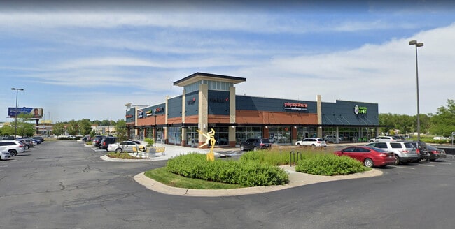
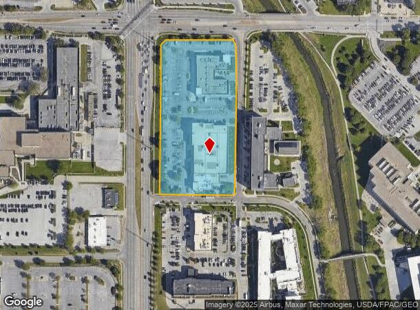
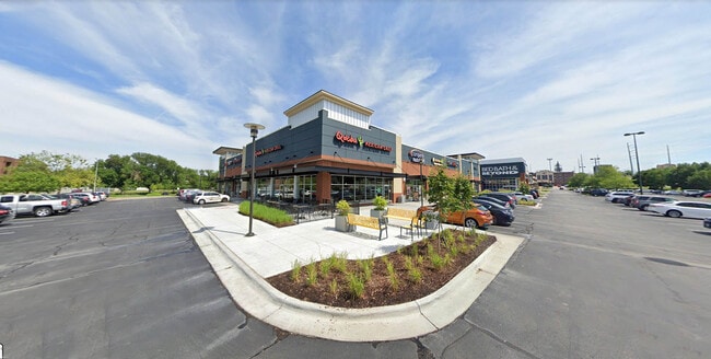
1110 S 71St St
Omaha, NE-IA
Aksarben Business & Ed Campus
0151-0367-05
AKSARBEN BUSINESS & ED CAMPUS RP 4* LOT 3 BLOCK 0 -EX IRR E 11.35 X 167.43 FT STRIP FOR RWY- LOT 3 IRREG 4.893 AC
Regionalshoppingcenterormallwithanchorstore
Douglas
AE
Nebraska
31153C0060G
3
2024
4.89 AC
2025
Central Omaha
007001
Omaha/Council Bluffs
57,280 SF
DEMOGRAPHICS near 1110 S 71St St
1 Mile
3 Mile
5 Mile
2024 Total Population
8,988
102,170
325,425
2029 Population
9,131
103,590
331,741
Pop Growth 2024-2029
+ 1.59%
+ 1.39%
+ 1.94%
Average Age
37
39
37
2024 Total Households
4,008
45,965
135,495
HH Growth 2024-2029
+ 1.72%
+ 1.49%
+ 2.06%
Median Household Inc
$65,440
$64,089
$56,522
Avg Household Size
1.90
2.10
2.30
2024 Avg HH Vehicles
2.00
2.00
2.00
Median Home Value
$248,192
$208,250
$185,417
Median Year Built
1965
1960
1965
Nearby Places
Map Layers
Map Styles
 Street
 Aerial
- Restaurants
- Banks
- Shops
- Fitness
- Groceries
PUBLIC TRANSPORTATION
COMMUTER RAIL
DRIVE
WALK
Distance
13 min
5.3 mi
DRIVE
WALK
Distance
13 min
6.9 mi
AIRPORT
Eppley Airfield
DRIVE
WALK
Distance
Eppley Airfield
21 min
9.1 mi
SALE & LEASE HISTORY
LISTING DATE
SALE/LEASE

Jul 19, 2017
For Lease
Nearby Properties
Address
Land Use
TOTAL SIZE
Lot Size
Zoning
Address
Land Use
TOTAL SIZE
Lot Size
Zoning
866,622 SF
20.67 AC
Address
Land Use
TOTAL SIZE
Lot Size
Zoning
255,351 SF
0.79 AC
Address
Land Use
TOTAL SIZE
Lot Size
Zoning
326,069 SF
4.88 AC
Address
Land Use
TOTAL SIZE
Lot Size
Zoning
370,431 SF
8.57 AC
Address
Land Use
TOTAL SIZE
Lot Size
Zoning
702,563 SF
18.85 AC
Address
Land Use
TOTAL SIZE
Lot Size
Zoning
341,667 SF
24.15 AC
Address
Land Use
TOTAL SIZE
Lot Size
Zoning
687,804 SF
23.14 AC
Address
Land Use
TOTAL SIZE
Lot Size
Zoning
304,034 SF
5.11 AC
R7
Address
Land Use
TOTAL SIZE
Lot Size
Zoning
387,860 SF
7.20 AC
Address
Land Use
TOTAL SIZE
Lot Size
Zoning
398,593 SF
10.80 AC
Address
Land Use
TOTAL SIZE
Lot Size
Zoning
282,688 SF
18.71 AC
Address
Land Use
TOTAL SIZE
Lot Size
Zoning
206,591 SF
0.60 AC
Address
Land Use
TOTAL SIZE
Lot Size
Zoning
389,488 SF
4.30 AC
Address
Land Use
TOTAL SIZE
Lot Size
Zoning
145,190 SF
5.45 AC
Address
Land Use
TOTAL SIZE
Lot Size
Zoning
130,286 SF
4.31 AC
GO
Address
Land Use
TOTAL SIZE
Lot Size
Zoning
96,871 SF
9.98 AC
Address
Land Use
TOTAL SIZE
Lot Size
Zoning
256,558 SF
7 AC
GI
Address
Land Use
TOTAL SIZE
Lot Size
Zoning
238,954 SF
14.65 AC
Address
Land Use
TOTAL SIZE
Lot Size
Zoning
120,078 SF
1.24 AC
MU
Address
Land Use
TOTAL SIZE
Lot Size
Zoning
897,738 SF
52.16 AC
Address
Land Use
TOTAL SIZE
Lot Size
Zoning
329,515 SF
6.37 AC
Address
Land Use
TOTAL SIZE
Lot Size
Zoning
114,936 SF
1.93 AC
Address
Land Use
TOTAL SIZE
Lot Size
Zoning
405,820 SF
2.10 AC
Address
Land Use
TOTAL SIZE
Lot Size
Zoning
129,910 SF
0.92 AC
Address
Land Use
TOTAL SIZE
Lot Size
Zoning
646,213 SF
37.22 AC
Address
Land Use
TOTAL SIZE
Lot Size
Zoning
354,615 SF
18.13 AC
R6
Address
Land Use
TOTAL SIZE
Lot Size
Zoning
234,332 SF
12.30 AC
Address
Land Use
TOTAL SIZE
Lot Size
Zoning
112,933 SF
1.23 AC
MU
Address
Land Use
TOTAL SIZE
Lot Size
Zoning
249,902 SF
13.02 AC
CC
Address
Land Use
TOTAL SIZE
Lot Size
Zoning
407,410 SF
4.03 AC
The World's #1 Commercial Real Estate Marketplace
Connect with us
© 2026 CoStar Group
The information above has been obtained from sources believed reliable. While we do not doubt its accuracy we have not verified it and make no guarantee, warranty or representation about it. It is your responsibility to independently confirm its accuracy and completeness. Any projections, opinions, assumptions, or estimates used are for example only and do not represent the current or future performance of the property. The value of this transaction to you depends on tax and other factors which should be evaluated by your tax, financial, and legal advisors. You and your advisors should conduct a careful, independent investigation of the property to determine to your satisfaction the suitability of the property for your needs.