Property Record
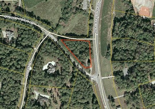
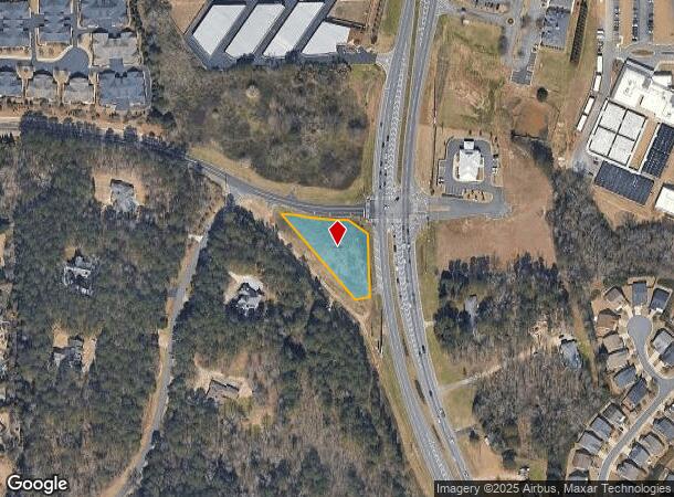
Stoney Point Rd, Cumming, GA 30041
NEARBY LISTINGS FOR SALE OR LEASE
Property Detail
Stoney Point Rd
Atlanta-Sandy Springs-Roswell, GA
Peachtree Pkwy
109-024
2-1 665-666
Industrialgeneral
Forsyth
X
Georgia
13117C0143F
665
2024
0.72 AC
2025
N Fulton/Forsyth County
130509
Atlanta
DEMOGRAPHICS near Stoney Point Rd
1 Mile
3 Mile
5 Mile
2024 Total Population
5,867
55,039
155,758
2029 Population
6,727
63,711
177,799
Pop Growth 2024-2029
+ 14.66%
+ 15.76%
+ 14.15%
Average Age
41
38
38
2024 Total Households
2,104
17,688
50,736
HH Growth 2024-2029
+ 14.64%
+ 15.83%
+ 14.25%
Median Household Inc
$137,258
$142,436
$139,741
Avg Household Size
2.80
3.10
3.00
2024 Avg HH Vehicles
2.00
2.00
2.00
Median Home Value
$488,769
$471,212
$482,257
Median Year Built
2008
2006
2003
Nearby Places
- Restaurants
- Banks
- Shops
- Fitness
- Groceries
SALE & LEASE HISTORY
LISTING DATE
SALE/LEASE

Sep 24, 2016
For Sale
May 31, 2017
For Sale
May 31, 2017
For Sale
May 31, 2017
For Sale
Mar 13, 2017
For Sale
Nearby Properties
Address
Land Use
TOTAL SIZE
Lot Size
Zoning
Address
Land Use
TOTAL SIZE
Lot Size
Zoning
8,848 SF
15.75 AC
PUD
Address
Land Use
TOTAL SIZE
Lot Size
Zoning
475,011 SF
39.64 AC
CBD
Address
Land Use
TOTAL SIZE
Lot Size
Zoning
281,780 SF
19.08 AC
PUD
Address
Land Use
TOTAL SIZE
Lot Size
Zoning
47,721 SF
12.99 AC
CBD
Address
Land Use
TOTAL SIZE
Lot Size
Zoning
249,386 SF
33.24 AC
RES6
Address
Land Use
TOTAL SIZE
Lot Size
Zoning
4,616 SF
12.30 AC
R3
Address
Land Use
TOTAL SIZE
Lot Size
Zoning
291,232 SF
71.66 AC
RES3
Address
Land Use
TOTAL SIZE
Lot Size
Zoning
83,161 SF
277.43 AC
A1
Address
Land Use
TOTAL SIZE
Lot Size
Zoning
222,893 SF
103.13 AC
M1
Address
Land Use
TOTAL SIZE
Lot Size
Zoning
141,728 SF
32.45 AC
M1
Address
Land Use
TOTAL SIZE
Lot Size
Zoning
232,832 SF
17.74 AC
M1
Address
Land Use
TOTAL SIZE
Lot Size
Zoning
141,650 SF
21.58 AC
M1
Address
Land Use
TOTAL SIZE
Lot Size
Zoning
186,015 SF
13.72 AC
MP
Address
Land Use
TOTAL SIZE
Lot Size
Zoning
122,964 SF
7.82 AC
RES6
Address
Land Use
TOTAL SIZE
Lot Size
Zoning
60,235 SF
11.94 AC
CBD
Address
Land Use
TOTAL SIZE
Lot Size
Zoning
192,316 SF
51.53 AC
A1
Address
Land Use
TOTAL SIZE
Lot Size
Zoning
16.56 AC
MP
Address
Land Use
TOTAL SIZE
Lot Size
Zoning
101,510 SF
15.45 AC
CBD
Address
Land Use
TOTAL SIZE
Lot Size
Zoning
80,598 SF
10.07 AC
CBD
Address
Land Use
TOTAL SIZE
Lot Size
Zoning
155,701 SF
10.35 AC
R3
Address
Land Use
TOTAL SIZE
Lot Size
Zoning
136,122 SF
9.95 AC
M1
Address
Land Use
TOTAL SIZE
Lot Size
Zoning
136,660 SF
21.47 AC
M1
Address
Land Use
TOTAL SIZE
Lot Size
Zoning
2,376 SF
68.90 AC
A1
Address
Land Use
TOTAL SIZE
Lot Size
Zoning
73,022 SF
6.57 AC
CBD
Address
Land Use
TOTAL SIZE
Lot Size
Zoning
3,366 SF
20.07 AC
PUD
Address
Land Use
TOTAL SIZE
Lot Size
Zoning
76,622 SF
49.06 AC
A1
Address
Land Use
TOTAL SIZE
Lot Size
Zoning
73,963 SF
10.57 AC
CBD
Address
Land Use
TOTAL SIZE
Lot Size
Zoning
127,096 SF
7.25 AC
M1
Address
Land Use
TOTAL SIZE
Lot Size
Zoning
98,593 SF
34.52 AC
R2R
Address
Land Use
TOTAL SIZE
Lot Size
Zoning
138,000 SF
14.07 AC
M1
The World's #1 Commercial Real Estate Marketplace
Connect with us
© 2025 CoStar Group
The information above has been obtained from sources believed reliable. While we do not doubt its accuracy we have not verified it and make no guarantee, warranty or representation about it. It is your responsibility to independently confirm its accuracy and completeness. Any projections, opinions, assumptions, or estimates used are for example only and do not represent the current or future performance of the property. The value of this transaction to you depends on tax and other factors which should be evaluated by your tax, financial, and legal advisors. You and your advisors should conduct a careful, independent investigation of the property to determine to your satisfaction the suitability of the property for your needs.