Property Record
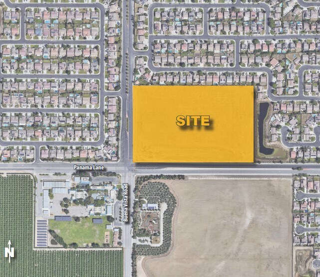
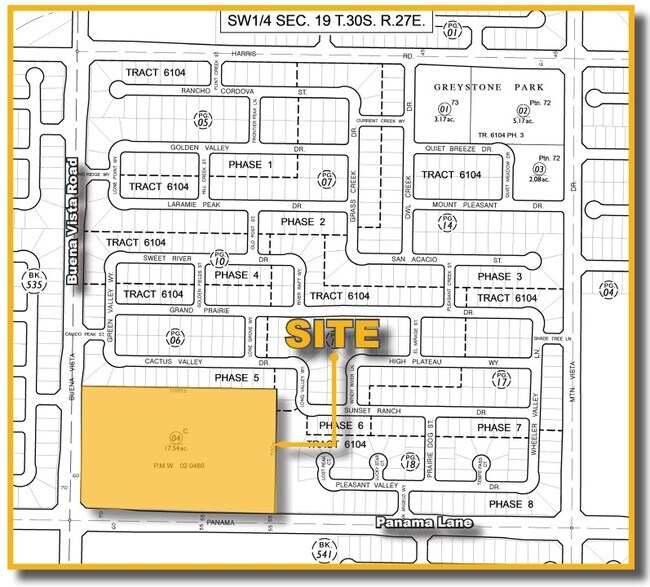
11100 Panama Ln, Bakersfield, CA 93311

Property Detail
11100 Panama Ln
544-030-04-00-6
SECTION 19 , TOWNSHIP 30 , RANGE 27 , QUARTER SW
Commercialacreage
KERN
C-2
California
B and X Area of moderate flood hazard, usually the area between the limits of the 100-year and 500-year floods.
17.54 AC
2024
Southwest Bakersfield
2025
Bakersfield
003134
Bakersfield-Delano, CA
NEARBY LISTINGS FOR SALE OR LEASE
DEMOGRAPHICS near 11100 Panama Ln
1 mile
3 mile
5 mile
2025 Total Population
12,712
55,787
160,836
2030 Population
13,241
57,077
164,397
Pop Growth 2025-2030
+ 4.16%
+ 2.31%
+ 2.21%
Average Age
33
36
37
2025 Total Households
3,295
17,195
51,505
HH Growth 2025-2030
+ 4.10%
+ 2.06%
+ 2.10%
Median Household Inc
$131,684
$108,045
$97,325
Avg Household Size
3.80
3.20
3.10
2025 Avg HH Vehicles
2.00
2.00
2.00
Median Home Value
$427,347
$421,550
$401,135
Median Year Built
2008
2000
1994
Nearby Places
Map Layers
Map Styles
 Street
 Aerial
Layers
 Traffic
 Biking
Places
Listings with unknown addresses are not visible on the map
- Restaurants
- Banks
- Shops
- Fitness
- Groceries
PUBLIC TRANSPORTATION
AIRPORT
Meadows Field
Drive
Walk
Distance
Meadows Field
28 min
13.6 mi
SALE & LEASE HISTORY
LISTING DATE
SALE/LEASE

Dec 13, 2022
For Sale
Nearby Properties
Address
Land Use
TOTAL SIZE
Lot Size
Zoning
Address
Land Use
TOTAL SIZE
Lot Size
Zoning
587,976 SF
40.01 AC
M-2
Address
Land Use
TOTAL SIZE
Lot Size
Zoning
354,000 SF
20 AC
M2
Address
Land Use
TOTAL SIZE
Lot Size
Zoning
14,529 SF
27.73 AC
R-2
Address
Land Use
TOTAL SIZE
Lot Size
Zoning
14,500 SF
33.82 AC
C2
Address
Land Use
TOTAL SIZE
Lot Size
Zoning
269,429 SF
12.71 AC
R-2
Address
Land Use
TOTAL SIZE
Lot Size
Zoning
138,559 SF
11.92 AC
C-2 PCD
Address
Land Use
TOTAL SIZE
Lot Size
Zoning
37,760 SF
12.16 AC
R3
Address
Land Use
TOTAL SIZE
Lot Size
Zoning
93,274 SF
6.20 AC
R-2
Address
Land Use
TOTAL SIZE
Lot Size
Zoning
223,557 SF
21.31 AC
PCD
Address
Land Use
TOTAL SIZE
Lot Size
Zoning
192,500 SF
11.48 AC
R-2
Address
Land Use
TOTAL SIZE
Lot Size
Zoning
83,936 SF
4.39 AC
R-2
Address
Land Use
TOTAL SIZE
Lot Size
Zoning
88,988 SF
9.82 AC
C-2
Address
Land Use
TOTAL SIZE
Lot Size
Zoning
24,888 SF
5.75 AC
WM-R2
Address
Land Use
TOTAL SIZE
Lot Size
Zoning
63,702 SF
6.82 AC
WM C-O
Address
Land Use
TOTAL SIZE
Lot Size
Zoning
Address
Land Use
TOTAL SIZE
Lot Size
Zoning
23,600 SF
8.17 AC
C2
Address
Land Use
TOTAL SIZE
Lot Size
Zoning
135,549 SF
12 AC
M1
Address
Land Use
TOTAL SIZE
Lot Size
Zoning
32,749 SF
8.84 AC
R-2
Address
Land Use
TOTAL SIZE
Lot Size
Zoning
58,496 SF
7.32 AC
Address
Land Use
TOTAL SIZE
Lot Size
Zoning
12,008 SF
7.18 AC
Address
Land Use
TOTAL SIZE
Lot Size
Zoning
83,936 SF
4.39 AC
R-2
Address
Land Use
TOTAL SIZE
Lot Size
Zoning
83,857 SF
5.01 AC
Address
Land Use
TOTAL SIZE
Lot Size
Zoning
161,608 SF
10.70 AC
M2
Address
Land Use
TOTAL SIZE
Lot Size
Zoning
Address
Land Use
TOTAL SIZE
Lot Size
Zoning
232,000 SF
15.74 AC
M-2
Address
Land Use
TOTAL SIZE
Lot Size
Zoning
113,910 SF
9.43 AC
M2
Address
Land Use
TOTAL SIZE
Lot Size
Zoning
149,777 SF
15.27 AC
C2
Address
Land Use
TOTAL SIZE
Lot Size
Zoning
140,235 SF
8 AC
M2
Address
Land Use
TOTAL SIZE
Lot Size
Zoning
150,000 SF
8.18 AC
M2
Address
Land Use
TOTAL SIZE
Lot Size
Zoning
7.55 AC
The World's #1 Commercial Real Estate Marketplace
Connect with us
© 2026 CoStar Group
The information above has been obtained from sources believed reliable. While we do not doubt its accuracy we have not verified it and make no guarantee, warranty or representation about it. It is your responsibility to independently confirm its accuracy and completeness. Any projections, opinions, assumptions, or estimates used are for example only and do not represent the current or future performance of the property. The value of this transaction to you depends on tax and other factors which should be evaluated by your tax, financial, and legal advisors. You and your advisors should conduct a careful, independent investigation of the property to determine to your satisfaction the suitability of the property for your needs.