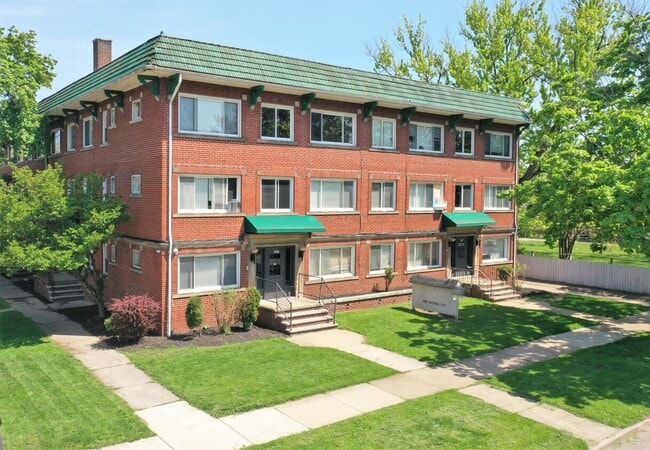
Property Record
3507 Bosworth Rd, Cleveland, OH 44111


NEARBY LISTINGS FOR SALE OR LEASE
Property Detail
3507 Bosworth Rd
Cleveland-Elyria, OH
Lorain Hlnds Resub
018-16-121
6 LORHIGHL 1814 ALL
Apartment
Cuyahoga
X
Ohio
39035C0159E
1814
2024
0.15 AC
2024
West Boulevard
102101
Cleveland
DEMOGRAPHICS near 3507 Bosworth Rd
1 Mile
3 Mile
5 Mile
2024 Total Population
21,374
159,284
314,457
2029 Population
20,436
153,936
304,953
Pop Growth 2024-2029
(4.39%)
(3.36%)
(3.02%)
Average Age
37
39
40
2024 Total Households
8,382
72,612
144,344
HH Growth 2024-2029
(4.65%)
(3.45%)
(3.09%)
Median Household Inc
$41,731
$46,106
$53,205
Avg Household Size
2.40
2.10
2.10
2024 Avg HH Vehicles
1.00
1.00
1.00
Median Home Value
$70,175
$131,097
$147,460
Median Year Built
1946
1947
1949
Nearby Places
Map Layers
Map Styles
 Street
 Aerial
- Restaurants
- Banks
- Shops
- Fitness
- Groceries
PUBLIC TRANSPORTATION
COMMUTER RAIL
Cleveland Lakefront Station (Blue Line - Greater Cleveland Regional Transit Authority Rapid Transit (The Rapid), Green Line - Greater Cleveland Regional Transit Authority Rapid Transit (The Rapid))
DRIVE
WALK
Distance
Cleveland Lakefront Station (Blue Line - Greater Cleveland Regional Transit Authority Rapid Transit (The Rapid), Green Line - Greater Cleveland Regional Transit Authority Rapid Transit (The Rapid))
18 min
7.7 mi
AIRPORT
Cleveland-Hopkins International
DRIVE
WALK
Distance
Cleveland-Hopkins International
16 min
7.4 mi
SALE & LEASE HISTORY
LISTING DATE
SALE/LEASE

Jun 05, 2023
For Sale
Nearby Properties
Address
Land Use
TOTAL SIZE
Lot Size
Zoning
Address
Land Use
TOTAL SIZE
Lot Size
Zoning
70.02 AC
GI
Address
Land Use
TOTAL SIZE
Lot Size
Zoning
518,244 SF
21.80 AC
Address
Land Use
TOTAL SIZE
Lot Size
Zoning
208,209 SF
12.10 AC
1F
Address
Land Use
TOTAL SIZE
Lot Size
Zoning
164,294 SF
13.81 AC
GI
Address
Land Use
TOTAL SIZE
Lot Size
Zoning
200,874 SF
3.30 AC
LR
Address
Land Use
TOTAL SIZE
Lot Size
Zoning
809,240 SF
36.27 AC
L-I
Address
Land Use
TOTAL SIZE
Lot Size
Zoning
340,593 SF
10.10 AC
G-1
Address
Land Use
TOTAL SIZE
Lot Size
Zoning
168,750 SF
18.55 AC
GI
Address
Land Use
TOTAL SIZE
Lot Size
Zoning
123,130 SF
21.88 AC
GI
Address
Land Use
TOTAL SIZE
Lot Size
Zoning
519,592 SF
69.70 AC
L-I
Address
Land Use
TOTAL SIZE
Lot Size
Zoning
361,287 SF
86.50 AC
2F
Address
Land Use
TOTAL SIZE
Lot Size
Zoning
258,852 SF
5.20 AC
MF2
Address
Land Use
TOTAL SIZE
Lot Size
Zoning
78,622 SF
11.78 AC
CB
Address
Land Use
TOTAL SIZE
Lot Size
Zoning
132.06 AC
IA
Address
Land Use
TOTAL SIZE
Lot Size
Zoning
389,067 SF
12.05 AC
A-H
Address
Land Use
TOTAL SIZE
Lot Size
Zoning
59,913 SF
0.92 AC
LR
Address
Land Use
TOTAL SIZE
Lot Size
Zoning
128,902 SF
7.12 AC
PD
Address
Land Use
TOTAL SIZE
Lot Size
Zoning
142,740 SF
1.83 AC
MF-2
Address
Land Use
TOTAL SIZE
Lot Size
Zoning
126,661 SF
7.07 AC
PD
Address
Land Use
TOTAL SIZE
Lot Size
Zoning
278,256 SF
0.81 AC
C1
Address
Land Use
TOTAL SIZE
Lot Size
Zoning
228,712 SF
10.10 AC
C3
Address
Land Use
TOTAL SIZE
Lot Size
Zoning
87,489 SF
8.01 AC
Address
Land Use
TOTAL SIZE
Lot Size
Zoning
64,000 SF
4.05 AC
Address
Land Use
TOTAL SIZE
Lot Size
Zoning
144,307 SF
2.99 AC
MF2
Address
Land Use
TOTAL SIZE
Lot Size
Zoning
16,023 SF
18.41 AC
SF-DH
Address
Land Use
TOTAL SIZE
Lot Size
Zoning
239,222 SF
22.87 AC
G-B
Address
Land Use
TOTAL SIZE
Lot Size
Zoning
105,632 SF
1.01 AC
MF3+
Address
Land Use
TOTAL SIZE
Lot Size
Zoning
181,049 SF
7.76 AC
GI
Address
Land Use
TOTAL SIZE
Lot Size
Zoning
208,675 SF
17.33 AC
G-B
Address
Land Use
TOTAL SIZE
Lot Size
Zoning
57,744 SF
2.30 AC
The World's #1 Commercial Real Estate Marketplace
Connect with us
© 2025 CoStar Group
The information above has been obtained from sources believed reliable. While we do not doubt its accuracy we have not verified it and make no guarantee, warranty or representation about it. It is your responsibility to independently confirm its accuracy and completeness. Any projections, opinions, assumptions, or estimates used are for example only and do not represent the current or future performance of the property. The value of this transaction to you depends on tax and other factors which should be evaluated by your tax, financial, and legal advisors. You and your advisors should conduct a careful, independent investigation of the property to determine to your satisfaction the suitability of the property for your needs.