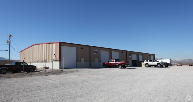
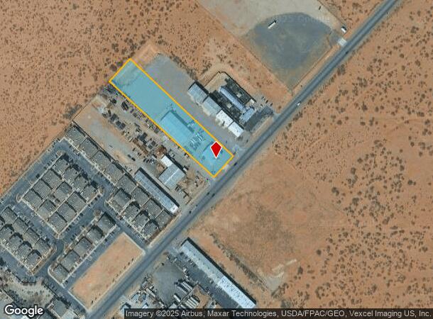
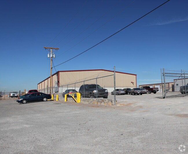
Property Record
11109 Dyer St, El Paso, TX 79934
NEARBY LISTINGS FOR SALE OR LEASE
Property Detail
11109 Dyer St
El Paso, TX
Tsp 1 Sec 1 T & P Surv
X580-999-1290-3520
80 TSP 1 SEC 29 T & P SURV TR 6-E (2.00 AC)
Commercialnec
El Paso
2024
Texas
2025
2 AC
010223
Northeast
14,700 SF
El Paso
DEMOGRAPHICS near 11109 Dyer St
1 Mile
3 Mile
5 Mile
2024 Total Population
4,642
53,474
86,343
2029 Population
4,687
53,837
86,939
Pop Growth 2024-2029
+ 0.97%
+ 0.68%
+ 0.69%
Average Age
33
34
36
2024 Total Households
1,594
18,446
30,754
HH Growth 2024-2029
+ 1.07%
+ 0.75%
+ 0.76%
Median Household Inc
$50,387
$56,207
$55,406
Avg Household Size
2.80
2.80
2.70
2024 Avg HH Vehicles
2.00
2.00
2.00
Median Home Value
$123,019
$139,468
$140,344
Median Year Built
1994
1993
1984
Nearby Places
Map Layers
Map Styles
 Street
 Aerial
- Restaurants
- Banks
- Shops
- Fitness
- Groceries
PUBLIC TRANSPORTATION
AIRPORT
El Paso International
DRIVE
WALK
Distance
El Paso International
27 min
14.8 mi
Nearby Properties
Address
Land Use
TOTAL SIZE
Lot Size
Zoning
Address
Land Use
TOTAL SIZE
Lot Size
Zoning
427,550 SF
40 AC
R4
Address
Land Use
TOTAL SIZE
Lot Size
Zoning
263,488 SF
13.88 AC
R3
Address
Land Use
TOTAL SIZE
Lot Size
Zoning
148,277 SF
17.14 AC
R4
Address
Land Use
TOTAL SIZE
Lot Size
Zoning
322,175 SF
22.17 AC
M1
Address
Land Use
TOTAL SIZE
Lot Size
Zoning
720,596 SF
23.98 AC
C2C
Address
Land Use
TOTAL SIZE
Lot Size
Zoning
123,824 SF
3.85 AC
A3
Address
Land Use
TOTAL SIZE
Lot Size
Zoning
76,082 SF
13.59 AC
Address
Land Use
TOTAL SIZE
Lot Size
Zoning
26,276 SF
1.53 AC
Address
Land Use
TOTAL SIZE
Lot Size
Zoning
424,325 SF
M1
Address
Land Use
TOTAL SIZE
Lot Size
Zoning
46,318 SF
4.92 AC
C3
Address
Land Use
TOTAL SIZE
Lot Size
Zoning
133,538 SF
10.04 AC
C1
Address
Land Use
TOTAL SIZE
Lot Size
Zoning
91,288 SF
14 AC
C1
Address
Land Use
TOTAL SIZE
Lot Size
Zoning
144,711 SF
10.50 AC
M1S
Address
Land Use
TOTAL SIZE
Lot Size
Zoning
39,270 SF
2.52 AC
C3
Address
Land Use
TOTAL SIZE
Lot Size
Zoning
129,076 SF
7.61 AC
C3C
Address
Land Use
TOTAL SIZE
Lot Size
Zoning
127,112 SF
7.24 AC
A2
Address
Land Use
TOTAL SIZE
Lot Size
Zoning
77.84 AC
M1
Address
Land Use
TOTAL SIZE
Lot Size
Zoning
40,726 SF
4 AC
R3A
Address
Land Use
TOTAL SIZE
Lot Size
Zoning
57,232 SF
11.16 AC
R4
Address
Land Use
TOTAL SIZE
Lot Size
Zoning
107,023 SF
5.47 AC
A2S
Address
Land Use
TOTAL SIZE
Lot Size
Zoning
241,802 SF
9.81 AC
M1
Address
Land Use
TOTAL SIZE
Lot Size
Zoning
89,321 SF
7.28 AC
C4
Address
Land Use
TOTAL SIZE
Lot Size
Zoning
25,061 SF
2.50 AC
C3
Address
Land Use
TOTAL SIZE
Lot Size
Zoning
318,722 SF
50 AC
M1
Address
Land Use
TOTAL SIZE
Lot Size
Zoning
35,842 SF
39.90 AC
R3
Address
Land Use
TOTAL SIZE
Lot Size
Zoning
172,809 SF
11.20 AC
A2
Address
Land Use
TOTAL SIZE
Lot Size
Zoning
67,837 SF
4.04 AC
C1S
Address
Land Use
TOTAL SIZE
Lot Size
Zoning
229.68 AC
RF
Address
Land Use
TOTAL SIZE
Lot Size
Zoning
140,610 SF
10.71 AC
A2
Address
Land Use
TOTAL SIZE
Lot Size
Zoning
84,149 SF
6.52 AC
A2
The World's #1 Commercial Real Estate Marketplace
Connect with us
© 2026 CoStar Group
The information above has been obtained from sources believed reliable. While we do not doubt its accuracy we have not verified it and make no guarantee, warranty or representation about it. It is your responsibility to independently confirm its accuracy and completeness. Any projections, opinions, assumptions, or estimates used are for example only and do not represent the current or future performance of the property. The value of this transaction to you depends on tax and other factors which should be evaluated by your tax, financial, and legal advisors. You and your advisors should conduct a careful, independent investigation of the property to determine to your satisfaction the suitability of the property for your needs.