Property Record
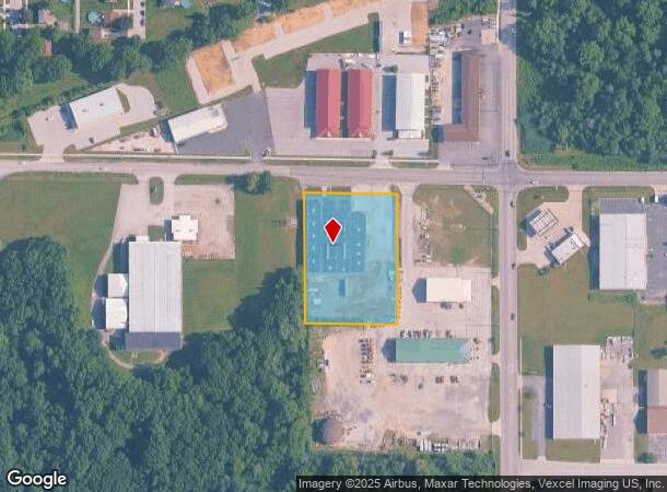
1111 E Main St, Griffith, IN 46319
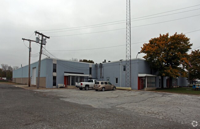

Property Detail
1111 E Main St
Chicago-Naperville-Elgin, IL-IN
Gatlins Addition Phase Two
45-11-02-226-002.000-006
GATLINS ADDITION PHASE TWO LOT 1
Commercialnec
Lake
X
Indiana
18089C0143E
1
2024
2.01 AC
2025
Indiana
040900
Chicago
30,000 SF
NEARBY LISTINGS FOR SALE OR LEASE
DEMOGRAPHICS near 1111 E Main St
1 mile
3 mile
5 mile
2024 Total Population
4,604
45,607
168,811
2029 Population
4,605
45,413
169,561
Pop Growth 2024-2029
+ 0.02%
(0.43%)
+ 0.44%
Average Age
41
41
41
2024 Total Households
1,879
18,491
67,502
HH Growth 2024-2029
0.00%
(0.46%)
+ 0.37%
Median Household Inc
$73,715
$70,492
$63,824
Avg Household Size
2.40
2.40
2.40
2024 Avg HH Vehicles
2.00
2.00
2.00
Median Home Value
$173,226
$198,893
$199,859
Median Year Built
1960
1967
1969
Nearby Places
Map Layers
Map Styles
 Street
 Aerial
Transit
 Traffic
 Biking
Places
Listings with unknown addresses are not visible on the map
- Restaurants
- Banks
- Shops
- Fitness
- Groceries
PUBLIC TRANSPORTATION
COMMUTER RAIL
Drive
Walk
Distance
15 min
5.9 mi
Clark Road (Gary) Station (South Shore Line - Northern Indiana Commuter Transportation District (South Shore Line))
Drive
Walk
Distance
Clark Road (Gary) Station (South Shore Line - Northern Indiana Commuter Transportation District (South Shore Line))
15 min
6.9 mi
AIRPORT
Chicago Midway International
Drive
Walk
Distance
Chicago Midway International
52 min
32.9 mi
SALE & LEASE HISTORY
LISTING DATE
SALE/LEASE

Sep 25, 2016
For Lease
Nearby Properties
Address
Land Use
TOTAL SIZE
Lot Size
Zoning
Address
Land Use
TOTAL SIZE
Lot Size
Zoning
168,766 SF
19.16 AC
Address
Land Use
TOTAL SIZE
Lot Size
Zoning
130,558 SF
9.89 AC
R33
Address
Land Use
TOTAL SIZE
Lot Size
Zoning
190,457 SF
10.63 AC
Address
Land Use
TOTAL SIZE
Lot Size
Zoning
132,147 SF
44.38 AC
R33
Address
Land Use
TOTAL SIZE
Lot Size
Zoning
80,444 SF
13.41 AC
R3
Address
Land Use
TOTAL SIZE
Lot Size
Zoning
105,000 SF
2.90 AC
Address
Land Use
TOTAL SIZE
Lot Size
Zoning
119,059 SF
10.12 AC
R33
Address
Land Use
TOTAL SIZE
Lot Size
Zoning
64,971 SF
6.98 AC
Address
Land Use
TOTAL SIZE
Lot Size
Zoning
34,116 SF
73.40 AC
Address
Land Use
TOTAL SIZE
Lot Size
Zoning
39,705 SF
23.63 AC
R33
Address
Land Use
TOTAL SIZE
Lot Size
Zoning
79,059 SF
7.07 AC
R3
Address
Land Use
TOTAL SIZE
Lot Size
Zoning
53,096 SF
8.64 AC
R3
Address
Land Use
TOTAL SIZE
Lot Size
Zoning
53,024 SF
43.30 AC
Address
Land Use
TOTAL SIZE
Lot Size
Zoning
68.50 AC
Address
Land Use
TOTAL SIZE
Lot Size
Zoning
33,920 SF
83.34 AC
Address
Land Use
TOTAL SIZE
Lot Size
Zoning
39,814 SF
2.49 AC
Address
Land Use
TOTAL SIZE
Lot Size
Zoning
148,851 SF
20.81 AC
Address
Land Use
TOTAL SIZE
Lot Size
Zoning
74,229 SF
10.04 AC
Address
Land Use
TOTAL SIZE
Lot Size
Zoning
28,138 SF
2.33 AC
R33
Address
Land Use
TOTAL SIZE
Lot Size
Zoning
44,960 SF
4.80 AC
Address
Land Use
TOTAL SIZE
Lot Size
Zoning
121,900 SF
8.79 AC
R3
Address
Land Use
TOTAL SIZE
Lot Size
Zoning
111,363 SF
9.60 AC
Address
Land Use
TOTAL SIZE
Lot Size
Zoning
98,658 SF
7.26 AC
R33
Address
Land Use
TOTAL SIZE
Lot Size
Zoning
14,501 SF
70.85 AC
Address
Land Use
TOTAL SIZE
Lot Size
Zoning
31,779 SF
2.67 AC
R3
Address
Land Use
TOTAL SIZE
Lot Size
Zoning
6,760 SF
77.37 AC
Address
Land Use
TOTAL SIZE
Lot Size
Zoning
41,406 SF
2.80 AC
R33
Address
Land Use
TOTAL SIZE
Lot Size
Zoning
38,988 SF
7.27 AC
R33
Address
Land Use
TOTAL SIZE
Lot Size
Zoning
81,154 SF
6.16 AC
R3
Address
Land Use
TOTAL SIZE
Lot Size
Zoning
24,964 SF
3.72 AC
The World's #1 Commercial Real Estate Marketplace
Connect with us
© 2026 CoStar Group
The information above has been obtained from sources believed reliable. While we do not doubt its accuracy we have not verified it and make no guarantee, warranty or representation about it. It is your responsibility to independently confirm its accuracy and completeness. Any projections, opinions, assumptions, or estimates used are for example only and do not represent the current or future performance of the property. The value of this transaction to you depends on tax and other factors which should be evaluated by your tax, financial, and legal advisors. You and your advisors should conduct a careful, independent investigation of the property to determine to your satisfaction the suitability of the property for your needs.