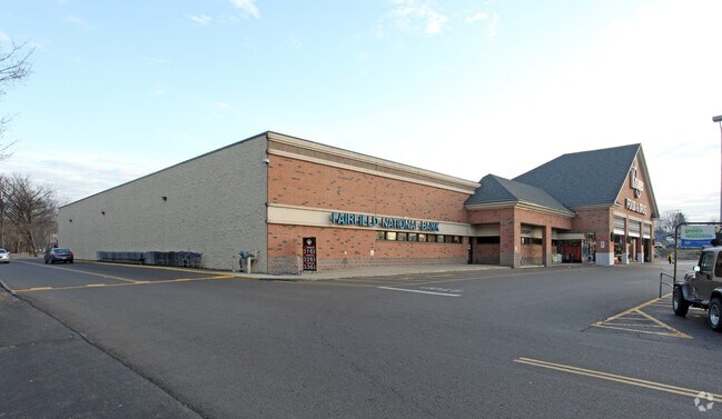
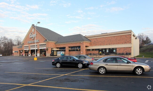
Property Record
1111 E Main St, Lancaster, OH 43130

Property Detail
1111 E Main St
Columbus, OH
R18T14S5-90-CHAS W &RENA GOOD ADD PT LOTS 15W-18W 11.75 AC .35 AC ( 15,261.89 SQ FT) BIKE PATH
05-35017-300
Fairfield
Medicalbuilding
Ohio
AE The base floodplain where base flood elevations are provided. AE Zones are now used on new format FIRMs instead of A1-A30 Zones.
15
2024
11.84 AC
2025
Fairfield County
031300
Columbus
128,515 SF
NEARBY LISTINGS FOR SALE OR LEASE
DEMOGRAPHICS near 1111 E Main St
1 mile
3 mile
5 mile
2025 Total Population
10,056
40,235
55,947
2030 Population
10,548
42,220
58,659
Pop Growth 2025-2030
+ 4.89%
+ 4.93%
+ 4.85%
Average Age
40
41
41
2025 Total Households
4,209
16,747
22,683
HH Growth 2025-2030
+ 5.01%
+ 5.14%
+ 5.12%
Median Household Inc
$58,055
$59,452
$64,241
Avg Household Size
2.30
2.30
2.40
2025 Avg HH Vehicles
2.00
2.00
2.00
Median Home Value
$166,442
$184,724
$211,032
Median Year Built
1951
1958
1967
Nearby Places
Map Layers
Map Styles
 Street
 Aerial
Transit
 Traffic
 Biking
Places
Listings with unknown addresses are not visible on the map
- Restaurants
- Banks
- Shops
- Fitness
- Groceries
PUBLIC TRANSPORTATION
AIRPORT
Rickenbacker International
Drive
Walk
Distance
Rickenbacker International
41 min
28.4 mi
John Glenn Columbus International
Drive
Walk
Distance
John Glenn Columbus International
44 min
31.6 mi
Freight Ports
Port of Toledo
Drive
Walk
Distance
Port of Toledo
221 min
180.4 mi
Nearby Properties
Address
Land Use
TOTAL SIZE
Lot Size
Zoning
Address
Land Use
TOTAL SIZE
Lot Size
Zoning
519,532 SF
9.92 AC
Address
Land Use
TOTAL SIZE
Lot Size
Zoning
895,709 SF
24.44 AC
Address
Land Use
TOTAL SIZE
Lot Size
Zoning
85,331 SF
18.94 AC
Address
Land Use
TOTAL SIZE
Lot Size
Zoning
111,535 SF
4.80 AC
Address
Land Use
TOTAL SIZE
Lot Size
Zoning
88,522 SF
36.77 AC
Address
Land Use
TOTAL SIZE
Lot Size
Zoning
141,894 SF
68.74 AC
Address
Land Use
TOTAL SIZE
Lot Size
Zoning
59,538 SF
22.24 AC
Address
Land Use
TOTAL SIZE
Lot Size
Zoning
67,322 SF
16.45 AC
Address
Land Use
TOTAL SIZE
Lot Size
Zoning
56,826 SF
7.04 AC
Address
Land Use
TOTAL SIZE
Lot Size
Zoning
155,985 SF
13.70 AC
Address
Land Use
TOTAL SIZE
Lot Size
Zoning
61,657 SF
10.45 AC
Address
Land Use
TOTAL SIZE
Lot Size
Zoning
229,660 SF
21.76 AC
Address
Land Use
TOTAL SIZE
Lot Size
Zoning
54,558 SF
11.24 AC
Address
Land Use
TOTAL SIZE
Lot Size
Zoning
29,579 SF
6.77 AC
Address
Land Use
TOTAL SIZE
Lot Size
Zoning
149,903 SF
43.98 AC
Address
Land Use
TOTAL SIZE
Lot Size
Zoning
421,760 SF
55.76 AC
Address
Land Use
TOTAL SIZE
Lot Size
Zoning
126,928 SF
12.29 AC
Address
Land Use
TOTAL SIZE
Lot Size
Zoning
45,361 SF
4.72 AC
Address
Land Use
TOTAL SIZE
Lot Size
Zoning
91,478 SF
11.98 AC
Address
Land Use
TOTAL SIZE
Lot Size
Zoning
177,448 SF
16.40 AC
Address
Land Use
TOTAL SIZE
Lot Size
Zoning
63,979 SF
6.80 AC
Address
Land Use
TOTAL SIZE
Lot Size
Zoning
49,353 SF
15.01 AC
Address
Land Use
TOTAL SIZE
Lot Size
Zoning
79,512 SF
41.59 AC
Address
Land Use
TOTAL SIZE
Lot Size
Zoning
58,633 SF
1.95 AC
Address
Land Use
TOTAL SIZE
Lot Size
Zoning
510,663 SF
44.12 AC
Address
Land Use
TOTAL SIZE
Lot Size
Zoning
63,241 SF
4.37 AC
Address
Land Use
TOTAL SIZE
Lot Size
Zoning
74,052 SF
20.03 AC
Address
Land Use
TOTAL SIZE
Lot Size
Zoning
280,714 SF
34.65 AC
Address
Land Use
TOTAL SIZE
Lot Size
Zoning
45,000 SF
0.72 AC
The World's #1 Commercial Real Estate Marketplace
Connect with us
© 2026 CoStar Group
The information above has been obtained from sources believed reliable. While we do not doubt its accuracy we have not verified it and make no guarantee, warranty or representation about it. It is your responsibility to independently confirm its accuracy and completeness. Any projections, opinions, assumptions, or estimates used are for example only and do not represent the current or future performance of the property. The value of this transaction to you depends on tax and other factors which should be evaluated by your tax, financial, and legal advisors. You and your advisors should conduct a careful, independent investigation of the property to determine to your satisfaction the suitability of the property for your needs.