Property Record
1111 E Stanley Blvd, Livermore, CA 94550
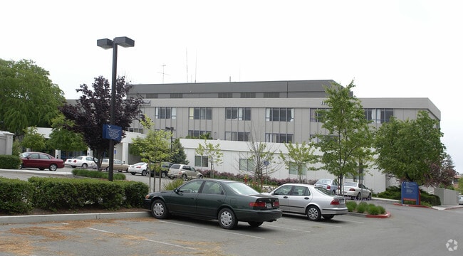

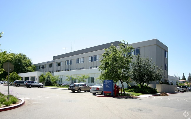
Property Detail
1111 E Stanley Blvd
97-85-274-15
LOT: 00002 BLK: 0004 AR: 0097 PAGE: 0085 ;LOT: 0000A BLK: PM: 0191 PAGE: 0051 ;LOT: 0000B BLK: PM: 0191 PAGE: 0051
Hospitalpublic
Alameda
B and X Area of moderate flood hazard, usually the area between the limits of the 100-year and 500-year floods.
California
2025
5.40 AC
2025
Livermore
451602
East Bay/Oakland
94,485 SF
Oakland-Fremont-Berkeley, CA
NEARBY LISTINGS FOR SALE OR LEASE
DEMOGRAPHICS near 1111 E Stanley Blvd
1 mile
3 mile
5 mile
2025 Total Population
21,465
67,274
126,391
2030 Population
21,496
67,057
125,830
Pop Growth 2025-2030
+ 0.14%
(0.32%)
(0.44%)
Average Age
42
42
42
2025 Total Households
7,905
24,315
44,625
HH Growth 2025-2030
+ 0.22%
(0.39%)
(0.56%)
Median Household Inc
$125,086
$152,518
$166,140
Avg Household Size
2.60
2.70
2.80
2025 Avg HH Vehicles
2.00
2.00
2.00
Median Home Value
$954,795
$1,043,083
$1,063,366
Median Year Built
1969
1977
1985
Nearby Places
Map Layers
Map Styles
 Street
 Aerial
Layers
 Traffic
 Biking
Places
Listings with unknown addresses are not visible on the map
- Restaurants
- Banks
- Shops
- Fitness
- Groceries
PUBLIC TRANSPORTATION
COMMUTER RAIL
Livermore Station (ACE Train - Altamont Corridor Express)
Drive
Walk
Distance
Livermore Station (ACE Train - Altamont Corridor Express)
3 min
1.1 mi
Vasco Rd Station (ACE Train - Altamont Corridor Express)
Drive
Walk
Distance
Vasco Rd Station (ACE Train - Altamont Corridor Express)
12 min
5.2 mi
AIRPORT
Metro Oakland International
Drive
Walk
Distance
Metro Oakland International
38 min
28.7 mi
Norman Y Mineta San Jose International
Drive
Walk
Distance
Norman Y Mineta San Jose International
42 min
30.8 mi
Freight Ports
Port of Redwood City
Drive
Walk
Distance
Port of Redwood City
54 min
37.7 mi
Nearby Properties
Address
Land Use
TOTAL SIZE
Lot Size
Zoning
Address
Land Use
TOTAL SIZE
Lot Size
Zoning
635,533 SF
32.55 AC
Address
Land Use
TOTAL SIZE
Lot Size
Zoning
212,048 SF
4.04 AC
Address
Land Use
TOTAL SIZE
Lot Size
Zoning
646,841 SF
38.83 AC
Address
Land Use
TOTAL SIZE
Lot Size
Zoning
367,734 SF
18.81 AC
Address
Land Use
TOTAL SIZE
Lot Size
Zoning
372,220 SF
19.11 AC
Address
Land Use
TOTAL SIZE
Lot Size
Zoning
294,940 SF
16.54 AC
Address
Land Use
TOTAL SIZE
Lot Size
Zoning
183,774 SF
15.21 AC
Address
Land Use
TOTAL SIZE
Lot Size
Zoning
178,938 SF
7 AC
Address
Land Use
TOTAL SIZE
Lot Size
Zoning
144,058 SF
11.52 AC
Address
Land Use
TOTAL SIZE
Lot Size
Zoning
116,167 SF
11.53 AC
Address
Land Use
TOTAL SIZE
Lot Size
Zoning
94,332 SF
8.89 AC
Address
Land Use
TOTAL SIZE
Lot Size
Zoning
40.97 AC
Address
Land Use
TOTAL SIZE
Lot Size
Zoning
92,905 SF
5.20 AC
Address
Land Use
TOTAL SIZE
Lot Size
Zoning
88,789 SF
5.63 AC
Address
Land Use
TOTAL SIZE
Lot Size
Zoning
178,145 SF
15.32 AC
Address
Land Use
TOTAL SIZE
Lot Size
Zoning
99,280 SF
6.11 AC
Address
Land Use
TOTAL SIZE
Lot Size
Zoning
105,596 SF
7.89 AC
Address
Land Use
TOTAL SIZE
Lot Size
Zoning
75,236 SF
6.42 AC
Address
Land Use
TOTAL SIZE
Lot Size
Zoning
70,472 SF
7.13 AC
Address
Land Use
TOTAL SIZE
Lot Size
Zoning
121,735 SF
7.03 AC
Address
Land Use
TOTAL SIZE
Lot Size
Zoning
135,039 SF
13.45 AC
Address
Land Use
TOTAL SIZE
Lot Size
Zoning
244,337 SF
8.27 AC
Address
Land Use
TOTAL SIZE
Lot Size
Zoning
157,610 SF
12.84 AC
Address
Land Use
TOTAL SIZE
Lot Size
Zoning
88,633 SF
9.54 AC
Address
Land Use
TOTAL SIZE
Lot Size
Zoning
51,178 SF
2.09 AC
CO
Address
Land Use
TOTAL SIZE
Lot Size
Zoning
74,620 SF
11.05 AC
Address
Land Use
TOTAL SIZE
Lot Size
Zoning
138,850 SF
10.38 AC
Address
Land Use
TOTAL SIZE
Lot Size
Zoning
119,184 SF
13.19 AC
Address
Land Use
TOTAL SIZE
Lot Size
Zoning
14.06 AC
Address
Land Use
TOTAL SIZE
Lot Size
Zoning
124,735 SF
8.14 AC
The World's #1 Commercial Real Estate Marketplace
Connect with us
© 2026 CoStar Group
The information above has been obtained from sources believed reliable. While we do not doubt its accuracy we have not verified it and make no guarantee, warranty or representation about it. It is your responsibility to independently confirm its accuracy and completeness. Any projections, opinions, assumptions, or estimates used are for example only and do not represent the current or future performance of the property. The value of this transaction to you depends on tax and other factors which should be evaluated by your tax, financial, and legal advisors. You and your advisors should conduct a careful, independent investigation of the property to determine to your satisfaction the suitability of the property for your needs.