Property Record
1111 Highway 33, West Bend, WI 53095
NEARBY LISTINGS FOR SALE OR LEASE
-
-
View all West Bend listings for sale on LoopNet.com
Property Detail
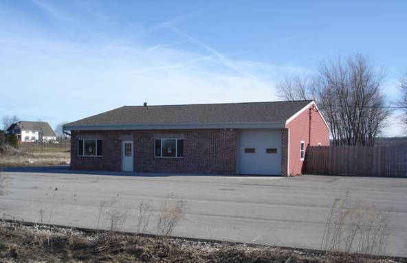
1111 Highway 33
Milwaukee-Waukesha-West Allis, WI
Certified Survey Map No 6142
T11-042800D
PT OF NE NW CSM 6142 PAR 2 DOC 1264894
Commercialnec
Washington
X
Wisconsin
55089C0090G
1 AC
2024
North Washington
2024
Milwaukee/Madison
420402
DEMOGRAPHICS near 1111 Highway 33
1 Mile
3 Mile
5 Mile
2024 Total Population
363
5,693
29,936
2029 Population
368
5,778
30,593
Pop Growth 2024-2029
+ 1.38%
+ 1.49%
+ 2.19%
Average Age
42
44
42
2024 Total Households
144
2,325
12,455
HH Growth 2024-2029
+ 2.08%
+ 1.46%
+ 2.29%
Median Household Inc
$90,789
$89,469
$74,598
Avg Household Size
2.40
2.40
2.30
2024 Avg HH Vehicles
2.00
2.00
2.00
Median Home Value
$288,461
$271,742
$249,606
Median Year Built
1984
1980
1976
Nearby Places
Map Layers
Map Styles
 Street
 Aerial
- Restaurants
- Banks
- Shops
- Fitness
- Groceries
Nearby Properties
Address
Land Use
TOTAL SIZE
Lot Size
Zoning
Address
Land Use
TOTAL SIZE
Lot Size
Zoning
12.71 AC
Address
Land Use
TOTAL SIZE
Lot Size
Zoning
27.12 AC
Address
Land Use
TOTAL SIZE
Lot Size
Zoning
36,488 SF
5.80 AC
Address
Land Use
TOTAL SIZE
Lot Size
Zoning
11.31 AC
Address
Land Use
TOTAL SIZE
Lot Size
Zoning
11.70 AC
Address
Land Use
TOTAL SIZE
Lot Size
Zoning
26,468 SF
5.03 AC
Address
Land Use
TOTAL SIZE
Lot Size
Zoning
Address
Land Use
TOTAL SIZE
Lot Size
Zoning
39.76 AC
Address
Land Use
TOTAL SIZE
Lot Size
Zoning
Address
Land Use
TOTAL SIZE
Lot Size
Zoning
1.25 AC
Address
Land Use
TOTAL SIZE
Lot Size
Zoning
Address
Land Use
TOTAL SIZE
Lot Size
Zoning
Address
Land Use
TOTAL SIZE
Lot Size
Zoning
3,050 SF
1.12 AC
Address
Land Use
TOTAL SIZE
Lot Size
Zoning
24.44 AC
Address
Land Use
TOTAL SIZE
Lot Size
Zoning
37.69 AC
Address
Land Use
TOTAL SIZE
Lot Size
Zoning
Address
Land Use
TOTAL SIZE
Lot Size
Zoning
Address
Land Use
TOTAL SIZE
Lot Size
Zoning
3.48 AC
Address
Land Use
TOTAL SIZE
Lot Size
Zoning
Address
Land Use
TOTAL SIZE
Lot Size
Zoning
39.88 AC
Address
Land Use
TOTAL SIZE
Lot Size
Zoning
39.01 AC
Address
Land Use
TOTAL SIZE
Lot Size
Zoning
11.77 AC
Address
Land Use
TOTAL SIZE
Lot Size
Zoning
Address
Land Use
TOTAL SIZE
Lot Size
Zoning
Address
Land Use
TOTAL SIZE
Lot Size
Zoning
0.75 AC
Address
Land Use
TOTAL SIZE
Lot Size
Zoning
0.73 AC
Address
Land Use
TOTAL SIZE
Lot Size
Zoning
Address
Land Use
TOTAL SIZE
Lot Size
Zoning
0.33 AC
Address
Land Use
TOTAL SIZE
Lot Size
Zoning
Address
Land Use
TOTAL SIZE
Lot Size
Zoning
3.82 AC
The World's #1 Commercial Real Estate Marketplace
Connect with us
© 2025 CoStar Group
The information above has been obtained from sources believed reliable. While we do not doubt its accuracy we have not verified it and make no guarantee, warranty or representation about it. It is your responsibility to independently confirm its accuracy and completeness. Any projections, opinions, assumptions, or estimates used are for example only and do not represent the current or future performance of the property. The value of this transaction to you depends on tax and other factors which should be evaluated by your tax, financial, and legal advisors. You and your advisors should conduct a careful, independent investigation of the property to determine to your satisfaction the suitability of the property for your needs.