Property Record
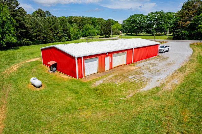
1111 Mount Tabor Rd, Hartselle, AL 35640


NEARBY LISTINGS FOR SALE OR LEASE
Property Detail
1111 Mount Tabor Rd
16-04-20-0-000-031.002
Dli&F Co Add 03
Autorepair
COM AT SE COR OF NW1/4 OF SE1/4 OF SEC 20, T7S, R3W TH W 340.04', TH CONT W 77.47' TO W R/W OF MT TABOR RD, TH CONT W 225.78'
X
Morgan
01103C0240F
Alabama
2025
3.40 AC
2024
Alabama North Area
005500
Other Market Areas
3,200 SF
Decatur, AL
DEMOGRAPHICS near 1111 Mount Tabor Rd
1 Mile
3 Mile
5 Mile
2024 Total Population
212
3,162
18,701
2029 Population
224
3,356
19,677
Pop Growth 2024-2029
+ 5.66%
+ 6.14%
+ 5.22%
Average Age
42
42
41
2024 Total Households
84
1,238
7,339
HH Growth 2024-2029
+ 5.95%
+ 6.22%
+ 5.33%
Median Household Inc
$73,499
$71,218
$61,793
Avg Household Size
2.50
2.50
2.50
2024 Avg HH Vehicles
2.00
2.00
2.00
Median Home Value
$223,684
$201,807
$186,413
Median Year Built
1995
1992
1985
Nearby Places
Map Layers
Map Styles
 Street
 Aerial
- Restaurants
- Banks
- Shops
- Fitness
- Groceries
PUBLIC TRANSPORTATION
AIRPORT
Huntsville International-Carl T Jones Field
DRIVE
WALK
Distance
Huntsville International-Carl T Jones Field
37 min
27.3 mi
Freight Ports
Port of Mobile
DRIVE
WALK
Distance
Port of Mobile
354 min
322.6 mi
Nearby Properties
Address
Land Use
TOTAL SIZE
Lot Size
Zoning
Address
Land Use
TOTAL SIZE
Lot Size
Zoning
135,937 SF
27 AC
Address
Land Use
TOTAL SIZE
Lot Size
Zoning
70,400 SF
7.60 AC
Address
Land Use
TOTAL SIZE
Lot Size
Zoning
282,610 SF
44 AC
Address
Land Use
TOTAL SIZE
Lot Size
Zoning
36,240 SF
10 AC
Address
Land Use
TOTAL SIZE
Lot Size
Zoning
120,000 SF
19.30 AC
Address
Land Use
TOTAL SIZE
Lot Size
Zoning
2,350 SF
10.50 AC
Address
Land Use
TOTAL SIZE
Lot Size
Zoning
Address
Land Use
TOTAL SIZE
Lot Size
Zoning
2,800 SF
6.50 AC
Address
Land Use
TOTAL SIZE
Lot Size
Zoning
38,948 SF
8 AC
Address
Land Use
TOTAL SIZE
Lot Size
Zoning
8,944 SF
3.03 AC
Address
Land Use
TOTAL SIZE
Lot Size
Zoning
16,608 SF
2.20 AC
Address
Land Use
TOTAL SIZE
Lot Size
Zoning
44 AC
Address
Land Use
TOTAL SIZE
Lot Size
Zoning
8,800 SF
5 AC
Address
Land Use
TOTAL SIZE
Lot Size
Zoning
12,000 SF
7.50 AC
Address
Land Use
TOTAL SIZE
Lot Size
Zoning
7,094 SF
2.20 AC
Address
Land Use
TOTAL SIZE
Lot Size
Zoning
9,296 SF
9.20 AC
Address
Land Use
TOTAL SIZE
Lot Size
Zoning
2,100 SF
1.17 AC
Address
Land Use
TOTAL SIZE
Lot Size
Zoning
36,000 SF
5 AC
Address
Land Use
TOTAL SIZE
Lot Size
Zoning
9,100 SF
1.80 AC
Address
Land Use
TOTAL SIZE
Lot Size
Zoning
31,500 SF
5 AC
Address
Land Use
TOTAL SIZE
Lot Size
Zoning
Address
Land Use
TOTAL SIZE
Lot Size
Zoning
26,800 SF
4.70 AC
Address
Land Use
TOTAL SIZE
Lot Size
Zoning
1,920 SF
20 AC
Address
Land Use
TOTAL SIZE
Lot Size
Zoning
3,200 SF
60 AC
Address
Land Use
TOTAL SIZE
Lot Size
Zoning
9,000 SF
4.50 AC
Address
Land Use
TOTAL SIZE
Lot Size
Zoning
2,400 SF
118 AC
Address
Land Use
TOTAL SIZE
Lot Size
Zoning
8,280 SF
2.40 AC
Address
Land Use
TOTAL SIZE
Lot Size
Zoning
3,911 SF
9 AC
Address
Land Use
TOTAL SIZE
Lot Size
Zoning
3,990 SF
2.20 AC
Address
Land Use
TOTAL SIZE
Lot Size
Zoning
2,182 SF
16 AC
The World's #1 Commercial Real Estate Marketplace
Connect with us
© 2026 CoStar Group
The information above has been obtained from sources believed reliable. While we do not doubt its accuracy we have not verified it and make no guarantee, warranty or representation about it. It is your responsibility to independently confirm its accuracy and completeness. Any projections, opinions, assumptions, or estimates used are for example only and do not represent the current or future performance of the property. The value of this transaction to you depends on tax and other factors which should be evaluated by your tax, financial, and legal advisors. You and your advisors should conduct a careful, independent investigation of the property to determine to your satisfaction the suitability of the property for your needs.