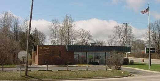
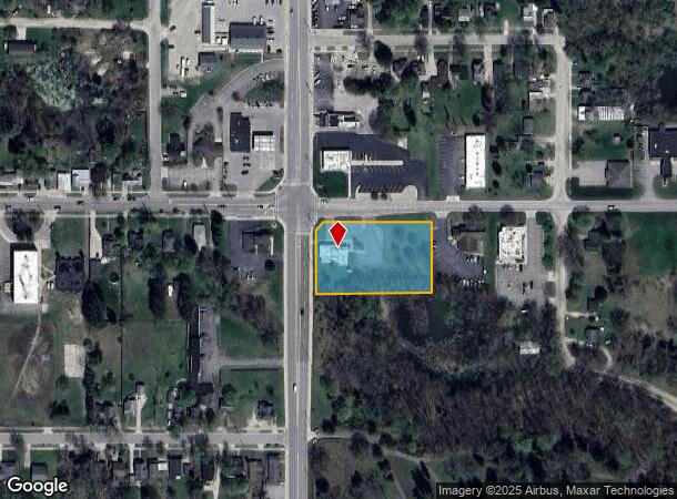
Property Record
1111 S Mitchell St, Cadillac, MI 49601

NEARBY LISTINGS FOR SALE OR LEASE
Property Detail
1111 S Mitchell St
Other Market Areas
Mitchells Plat
Cadillac, MI
LOTS 5 & 6, BLOCK 71, G. A. MITCHELLS PLAT OF THE SW 1/4 SEC. 3-21-9 EXC THE W 5 FT & EXC COM AT NW COR LOT 6, SLY ALG W LINE
10-083-00-070-00
Wexford
Commercialnec
Michigan
2024
5-25
2025
1.14 AC
380500
Michigan Northwest Area
DEMOGRAPHICS near 1111 S Mitchell St
1 Mile
3 Mile
5 Mile
2024 Total Population
4,905
13,385
17,960
2029 Population
5,021
13,760
18,495
Pop Growth 2024-2029
+ 2.36%
+ 2.80%
+ 2.98%
Average Age
40
41
42
2024 Total Households
2,105
5,541
7,403
HH Growth 2024-2029
+ 2.23%
+ 2.62%
+ 2.86%
Median Household Inc
$46,739
$53,264
$58,418
Avg Household Size
2.20
2.30
2.30
2024 Avg HH Vehicles
2.00
2.00
2.00
Median Home Value
$124,300
$124,691
$142,276
Median Year Built
1957
1968
1974
Nearby Places
Map Layers
Map Styles
 Street
 Aerial
- Restaurants
- Banks
- Shops
- Fitness
- Groceries
PUBLIC TRANSPORTATION
AIRPORT
Cherry Capital
DRIVE
WALK
Distance
Cherry Capital
71 min
48.7 mi
SALE & LEASE HISTORY
LISTING DATE
SALE/LEASE

Oct 12, 2024
For Lease
Nearby Properties
Address
Land Use
TOTAL SIZE
Lot Size
Zoning
Address
Land Use
TOTAL SIZE
Lot Size
Zoning
36.12 AC
Address
Land Use
TOTAL SIZE
Lot Size
Zoning
40,150 SF
60 AC
Address
Land Use
TOTAL SIZE
Lot Size
Zoning
26.90 AC
Address
Land Use
TOTAL SIZE
Lot Size
Zoning
44.78 AC
Address
Land Use
TOTAL SIZE
Lot Size
Zoning
19.84 AC
Address
Land Use
TOTAL SIZE
Lot Size
Zoning
12.09 AC
Address
Land Use
TOTAL SIZE
Lot Size
Zoning
3.04 AC
Address
Land Use
TOTAL SIZE
Lot Size
Zoning
4.30 AC
Address
Land Use
TOTAL SIZE
Lot Size
Zoning
13.47 AC
Address
Land Use
TOTAL SIZE
Lot Size
Zoning
Address
Land Use
TOTAL SIZE
Lot Size
Zoning
4.12 AC
Address
Land Use
TOTAL SIZE
Lot Size
Zoning
34.84 AC
Address
Land Use
TOTAL SIZE
Lot Size
Zoning
18.66 AC
Address
Land Use
TOTAL SIZE
Lot Size
Zoning
4.79 AC
Address
Land Use
TOTAL SIZE
Lot Size
Zoning
12.63 AC
Address
Land Use
TOTAL SIZE
Lot Size
Zoning
10.38 AC
Address
Land Use
TOTAL SIZE
Lot Size
Zoning
9.03 AC
Address
Land Use
TOTAL SIZE
Lot Size
Zoning
13.29 AC
Address
Land Use
TOTAL SIZE
Lot Size
Zoning
2.60 AC
Address
Land Use
TOTAL SIZE
Lot Size
Zoning
4.67 AC
Address
Land Use
TOTAL SIZE
Lot Size
Zoning
2.43 AC
Address
Land Use
TOTAL SIZE
Lot Size
Zoning
Address
Land Use
TOTAL SIZE
Lot Size
Zoning
13.48 AC
Address
Land Use
TOTAL SIZE
Lot Size
Zoning
3.97 AC
Address
Land Use
TOTAL SIZE
Lot Size
Zoning
Address
Land Use
TOTAL SIZE
Lot Size
Zoning
11.02 AC
Address
Land Use
TOTAL SIZE
Lot Size
Zoning
2.89 AC
Address
Land Use
TOTAL SIZE
Lot Size
Zoning
Address
Land Use
TOTAL SIZE
Lot Size
Zoning
3.42 AC
Address
Land Use
TOTAL SIZE
Lot Size
Zoning
7.62 AC
The World's #1 Commercial Real Estate Marketplace
Connect with us
© 2026 CoStar Group
The information above has been obtained from sources believed reliable. While we do not doubt its accuracy we have not verified it and make no guarantee, warranty or representation about it. It is your responsibility to independently confirm its accuracy and completeness. Any projections, opinions, assumptions, or estimates used are for example only and do not represent the current or future performance of the property. The value of this transaction to you depends on tax and other factors which should be evaluated by your tax, financial, and legal advisors. You and your advisors should conduct a careful, independent investigation of the property to determine to your satisfaction the suitability of the property for your needs.