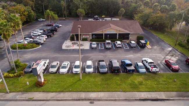
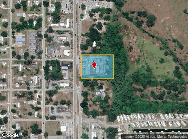
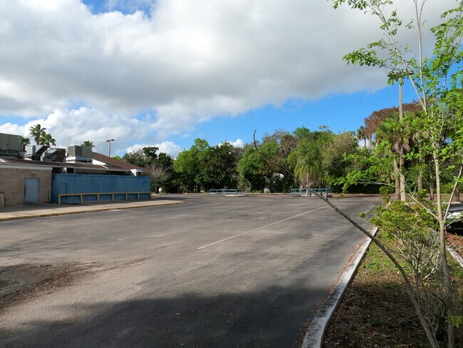
Property Record
1111 S Parrott Ave, Okeechobee, FL 34974

NEARBY LISTINGS FOR SALE OR LEASE
Property Detail
1111 S Parrott Ave
R2-21-37-35-0A00-00043-0000
Unplatted Lands Of The City
Restaurantbuilding
UNPLATTED LANDS OF THE CITY A PARCEL OF LAND LYING IN SECTION 21, TOWNSHIP 37 SOUTH, RANGE 35 EAST, OKEECHOBEE COUNTY, FLORIDA, BEING MORE PARTICULARLY DESCRIBED AS FOLLOWS: COMMENCE AT AN IRON PIPE FOUND IN CONCRETE MARKING THE SOUTHEAST CORNER OF S
X
Okeechobee
12043C0100D
Florida
2025
2.16 AC
2025
Florida Central South Area
910500
Other Market Areas
5,512 SF
Okeechobee, FL
DEMOGRAPHICS near 1111 S Parrott Ave
1 Mile
3 Mile
5 Mile
2024 Total Population
3,910
19,554
27,309
2029 Population
4,200
20,949
29,018
Pop Growth 2024-2029
+ 7.42%
+ 7.13%
+ 6.26%
Average Age
43
43
42
2024 Total Households
1,589
7,968
10,288
HH Growth 2024-2029
+ 7.87%
+ 7.43%
+ 6.74%
Median Household Inc
$49,582
$41,846
$44,776
Avg Household Size
2.40
2.40
2.50
2024 Avg HH Vehicles
2.00
2.00
2.00
Median Home Value
$155,670
$129,461
$135,501
Median Year Built
1987
1985
1985
Nearby Places
Map Layers
Map Styles
 Street
 Aerial
- Restaurants
- Banks
- Shops
- Fitness
- Groceries
PUBLIC TRANSPORTATION
COMMUTER RAIL
DRIVE
WALK
Distance
4 min
1.5 mi
SALE & LEASE HISTORY
LISTING DATE
SALE/LEASE

Sep 23, 2016
For Sale
Mar 14, 2019
For Lease
Feb 19, 2020
For Sale
Aug 04, 2017
For Sale
Nearby Properties
Address
Land Use
TOTAL SIZE
Lot Size
Zoning
Address
Land Use
TOTAL SIZE
Lot Size
Zoning
46,720 SF
108.57 AC
Address
Land Use
TOTAL SIZE
Lot Size
Zoning
213,251 SF
44.36 AC
Address
Land Use
TOTAL SIZE
Lot Size
Zoning
119,085 SF
14.79 AC
Address
Land Use
TOTAL SIZE
Lot Size
Zoning
194,141 SF
30.69 AC
Address
Land Use
TOTAL SIZE
Lot Size
Zoning
105,153 SF
4.13 AC
Address
Land Use
TOTAL SIZE
Lot Size
Zoning
166,487 SF
40 AC
Address
Land Use
TOTAL SIZE
Lot Size
Zoning
95,560 SF
10.55 AC
Address
Land Use
TOTAL SIZE
Lot Size
Zoning
122,024 SF
14.12 AC
Address
Land Use
TOTAL SIZE
Lot Size
Zoning
133,382 SF
1.52 AC
Address
Land Use
TOTAL SIZE
Lot Size
Zoning
84,774 SF
7.98 AC
Address
Land Use
TOTAL SIZE
Lot Size
Zoning
90,801 SF
15.10 AC
Address
Land Use
TOTAL SIZE
Lot Size
Zoning
158,401 SF
14.89 AC
Address
Land Use
TOTAL SIZE
Lot Size
Zoning
9,262 SF
21 AC
Address
Land Use
TOTAL SIZE
Lot Size
Zoning
98,033 SF
20.56 AC
Address
Land Use
TOTAL SIZE
Lot Size
Zoning
59,251 SF
0.47 AC
Address
Land Use
TOTAL SIZE
Lot Size
Zoning
122,498 SF
10.82 AC
Address
Land Use
TOTAL SIZE
Lot Size
Zoning
84,668 SF
10.74 AC
Address
Land Use
TOTAL SIZE
Lot Size
Zoning
88,120 SF
15.30 AC
Address
Land Use
TOTAL SIZE
Lot Size
Zoning
51,715 SF
41 AC
Address
Land Use
TOTAL SIZE
Lot Size
Zoning
50,633 SF
4.22 AC
Address
Land Use
TOTAL SIZE
Lot Size
Zoning
99,186 SF
7.05 AC
Address
Land Use
TOTAL SIZE
Lot Size
Zoning
9,231 SF
10.56 AC
Address
Land Use
TOTAL SIZE
Lot Size
Zoning
23,460 SF
8 AC
Address
Land Use
TOTAL SIZE
Lot Size
Zoning
44,801 SF
9.90 AC
Address
Land Use
TOTAL SIZE
Lot Size
Zoning
77,019 SF
7.76 AC
Address
Land Use
TOTAL SIZE
Lot Size
Zoning
58,312 SF
7.50 AC
Address
Land Use
TOTAL SIZE
Lot Size
Zoning
121,250 SF
10.31 AC
Address
Land Use
TOTAL SIZE
Lot Size
Zoning
2,887 SF
11.76 AC
Address
Land Use
TOTAL SIZE
Lot Size
Zoning
2,470 SF
258.06 AC
Address
Land Use
TOTAL SIZE
Lot Size
Zoning
2,100 SF
23.86 AC
The World's #1 Commercial Real Estate Marketplace
Connect with us
© 2025 CoStar Group
The information above has been obtained from sources believed reliable. While we do not doubt its accuracy we have not verified it and make no guarantee, warranty or representation about it. It is your responsibility to independently confirm its accuracy and completeness. Any projections, opinions, assumptions, or estimates used are for example only and do not represent the current or future performance of the property. The value of this transaction to you depends on tax and other factors which should be evaluated by your tax, financial, and legal advisors. You and your advisors should conduct a careful, independent investigation of the property to determine to your satisfaction the suitability of the property for your needs.