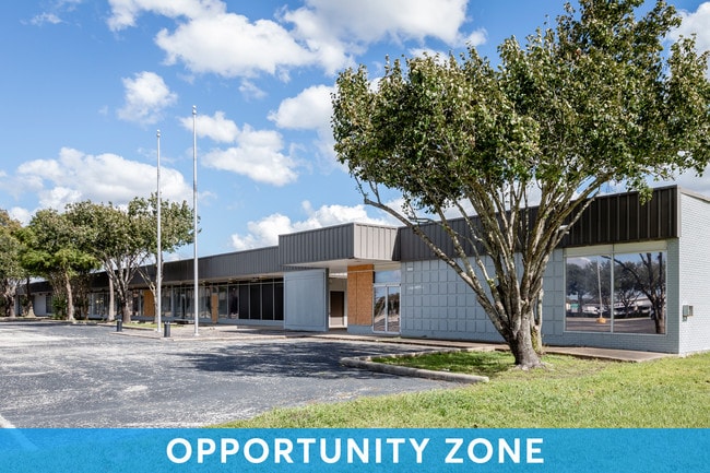
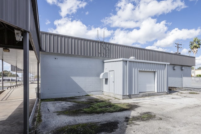
Property Record
1111 S Velasco St, Angleton, TX 77515


Save to a Folder
{{folder.Name}}
{{folder.ListingIds.length}} Properties
{{folder.ListingIds.length}} Property
Create a New Folder
Property Detail
1111 S Velasco St
0134-0102-000
A0134 E WALLER BLOCK 1 TRACT 1A-1A1-2A-2A1 (SD E/2) ACRES 13.3548 (ANGLETON)
Commercialnec
Brazoria
0134
Texas
B and X Area of moderate flood hazard, usually the area between the limits of the 100-year and 500-year floods.
1a1
2025
13.36 AC
2025
South Hwy 35
664100
Houston
71,060 SF
Houston-Pasadena-The Woodlands, TX
NEARBY LISTINGS FOR SALE OR LEASE
DEMOGRAPHICS near 1111 S Velasco St
1 mile
3 mile
5 mile
2025 Total Population
4,934
21,920
30,434
2030 Population
5,533
24,373
33,827
Pop Growth 2025-2030
+ 12.14%
+ 11.19%
+ 11.15%
Average Age
38
38
38
2025 Total Households
1,747
8,045
11,187
HH Growth 2025-2030
+ 12.42%
+ 11.49%
+ 11.47%
Median Household Inc
$73,511
$83,522
$87,682
Avg Household Size
2.80
2.70
2.70
2025 Avg HH Vehicles
2.00
2.00
2.00
Median Home Value
$175,260
$199,884
$227,502
Median Year Built
1978
1979
1984
Nearby Places
Map Layers
Map Styles
 Street
 Aerial
Layers
 Traffic
 Biking
Places
Listings with unknown addresses are not visible on the map
- Restaurants
- Banks
- Shops
- Fitness
- Groceries
SALE & LEASE HISTORY
LISTING DATE
SALE/LEASE

Oct 11, 2018
For Sale
Oct 10, 2019
For Sale
May 09, 2022
For Sale
May 08, 2019
For Sale
Nearby Properties
Address
Land Use
TOTAL SIZE
Lot Size
Zoning
Address
Land Use
TOTAL SIZE
Lot Size
Zoning
305,581 SF
8.28 AC
Address
Land Use
TOTAL SIZE
Lot Size
Zoning
318,545 SF
50.52 AC
Address
Land Use
TOTAL SIZE
Lot Size
Zoning
4,953 SF
19.41 AC
0151
Address
Land Use
TOTAL SIZE
Lot Size
Zoning
128,857 SF
10.65 AC
0140
Address
Land Use
TOTAL SIZE
Lot Size
Zoning
140,993 SF
5.79 AC
Address
Land Use
TOTAL SIZE
Lot Size
Zoning
92,290 SF
6.17 AC
0361
Address
Land Use
TOTAL SIZE
Lot Size
Zoning
45,000 SF
13.30 AC
0062
Address
Land Use
TOTAL SIZE
Lot Size
Zoning
12,221 SF
13.76 AC
0165
Address
Land Use
TOTAL SIZE
Lot Size
Zoning
14.46 AC
0138
Address
Land Use
TOTAL SIZE
Lot Size
Zoning
128,247 SF
17.49 AC
0114
Address
Land Use
TOTAL SIZE
Lot Size
Zoning
266,816 SF
20.34 AC
Address
Land Use
TOTAL SIZE
Lot Size
Zoning
116,629 SF
44.43 AC
Address
Land Use
TOTAL SIZE
Lot Size
Zoning
96,487 SF
1 AC
0011
Address
Land Use
TOTAL SIZE
Lot Size
Zoning
36,320 SF
10 AC
098A
Address
Land Use
TOTAL SIZE
Lot Size
Zoning
6.52 AC
Address
Land Use
TOTAL SIZE
Lot Size
Zoning
4.60 AC
Address
Land Use
TOTAL SIZE
Lot Size
Zoning
65,752 SF
Address
Land Use
TOTAL SIZE
Lot Size
Zoning
95,358 SF
4.78 AC
0140
Address
Land Use
TOTAL SIZE
Lot Size
Zoning
60.29 AC
0068
Address
Land Use
TOTAL SIZE
Lot Size
Zoning
18,091 SF
29.61 AC
Address
Land Use
TOTAL SIZE
Lot Size
Zoning
77,295 SF
6.63 AC
0056
Address
Land Use
TOTAL SIZE
Lot Size
Zoning
90,957 SF
5 AC
Address
Land Use
TOTAL SIZE
Lot Size
Zoning
1,930 SF
30 AC
0436
Address
Land Use
TOTAL SIZE
Lot Size
Zoning
33,546 SF
13.28 AC
Address
Land Use
TOTAL SIZE
Lot Size
Zoning
112,149 SF
35.71 AC
Address
Land Use
TOTAL SIZE
Lot Size
Zoning
69,265 SF
3.25 AC
Address
Land Use
TOTAL SIZE
Lot Size
Zoning
14.90 AC
Address
Land Use
TOTAL SIZE
Lot Size
Zoning
78,046 SF
4 AC
Address
Land Use
TOTAL SIZE
Lot Size
Zoning
14.52 AC
Address
Land Use
TOTAL SIZE
Lot Size
Zoning
34,125 SF
1.67 AC
The World's #1 Commercial Real Estate Marketplace
Connect with us
© 2026 CoStar Group
The information above has been obtained from sources believed reliable. While we do not doubt its accuracy we have not verified it and make no guarantee, warranty or representation about it. It is your responsibility to independently confirm its accuracy and completeness. Any projections, opinions, assumptions, or estimates used are for example only and do not represent the current or future performance of the property. The value of this transaction to you depends on tax and other factors which should be evaluated by your tax, financial, and legal advisors. You and your advisors should conduct a careful, independent investigation of the property to determine to your satisfaction the suitability of the property for your needs.