Property Record
1111 W Kimberly Rd, Davenport, IA 52806
This Property Is For Sale
NEARBY LISTINGS FOR SALE OR LEASE
-
-
View all Davenport listings for sale on LoopNet.com
Property Detail
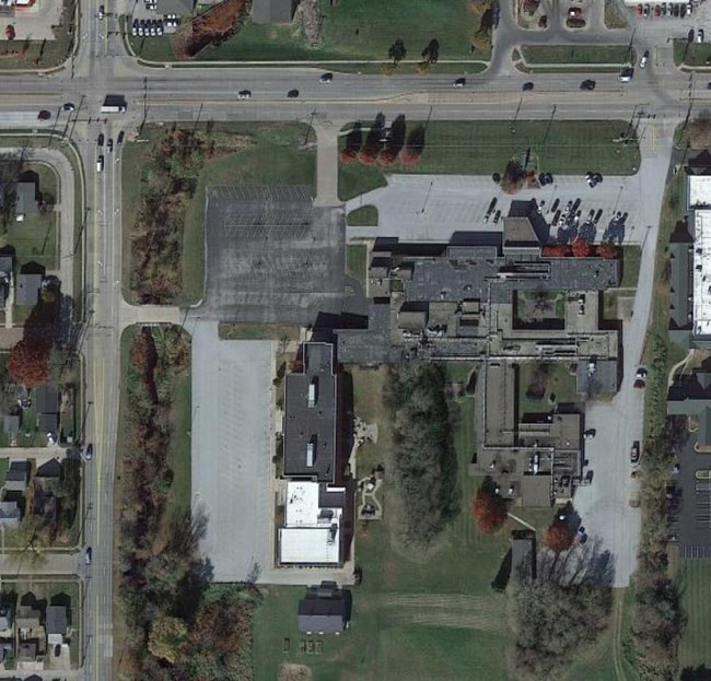
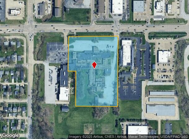
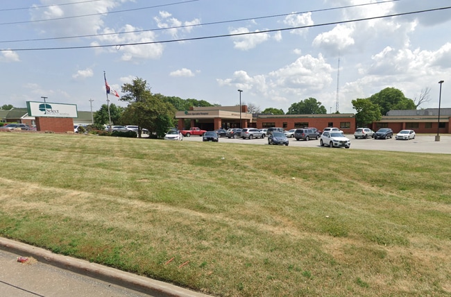
1111 W Kimberly Rd
P1409-04A
Section 14
Medicalbuilding
SEC:14 TWP:78 RNG:03PARCEL "2" PER SURVEY#2014-6009
X
Scott
19163C0365H
Iowa
2025
6.56 AC
2025
Greater Davenport
011800
Davenport/Moline/Rock Island
1,960 SF
Davenport-Moline-Rock Island, IA-IL
DEMOGRAPHICS near 1111 W Kimberly Rd
1 Mile
3 Mile
5 Mile
2024 Total Population
10,103
84,278
139,648
2029 Population
10,082
83,942
138,732
Pop Growth 2024-2029
(0.21%)
(0.40%)
(0.66%)
Average Age
43
39
39
2024 Total Households
4,481
35,376
57,615
HH Growth 2024-2029
(0.29%)
(0.35%)
(0.66%)
Median Household Inc
$60,106
$54,672
$55,692
Avg Household Size
2.10
2.20
2.30
2024 Avg HH Vehicles
2.00
2.00
2.00
Median Home Value
$155,809
$152,652
$153,494
Median Year Built
1966
1964
1963
Nearby Places
Map Layers
Map Styles
 Street
 Aerial
- Restaurants
- Banks
- Shops
- Fitness
- Groceries
PUBLIC TRANSPORTATION
AIRPORT
Quad Cities International
DRIVE
WALK
Distance
Quad Cities International
26 min
12.6 mi
Freight Ports
Port Milwaukee
DRIVE
WALK
Distance
Port Milwaukee
242 min
213.4 mi
Nearby Properties
Address
Land Use
TOTAL SIZE
Lot Size
Zoning
Address
Land Use
TOTAL SIZE
Lot Size
Zoning
7,934 SF
8.41 AC
Address
Land Use
TOTAL SIZE
Lot Size
Zoning
3,516 SF
26.74 AC
Address
Land Use
TOTAL SIZE
Lot Size
Zoning
197,194 SF
5.14 AC
Address
Land Use
TOTAL SIZE
Lot Size
Zoning
253,608 SF
9.29 AC
Address
Land Use
TOTAL SIZE
Lot Size
Zoning
3,500 SF
1.54 AC
Address
Land Use
TOTAL SIZE
Lot Size
Zoning
27,225 SF
40.34 AC
Address
Land Use
TOTAL SIZE
Lot Size
Zoning
27,306 SF
50.57 AC
Address
Land Use
TOTAL SIZE
Lot Size
Zoning
190,832 SF
3.88 AC
Address
Land Use
TOTAL SIZE
Lot Size
Zoning
300,718 SF
14.71 AC
Address
Land Use
TOTAL SIZE
Lot Size
Zoning
63,359 SF
12.01 AC
Address
Land Use
TOTAL SIZE
Lot Size
Zoning
352,332 SF
34.16 AC
Address
Land Use
TOTAL SIZE
Lot Size
Zoning
472,569 SF
47.24 AC
Address
Land Use
TOTAL SIZE
Lot Size
Zoning
123,823 SF
6.46 AC
Address
Land Use
TOTAL SIZE
Lot Size
Zoning
61,623 SF
2.18 AC
Address
Land Use
TOTAL SIZE
Lot Size
Zoning
76,853 SF
0.56 AC
Address
Land Use
TOTAL SIZE
Lot Size
Zoning
25,176 SF
13.85 AC
Address
Land Use
TOTAL SIZE
Lot Size
Zoning
26,472 SF
17.67 AC
Address
Land Use
TOTAL SIZE
Lot Size
Zoning
77,187 SF
0.88 AC
Address
Land Use
TOTAL SIZE
Lot Size
Zoning
27,312 SF
15.04 AC
Address
Land Use
TOTAL SIZE
Lot Size
Zoning
70,098 SF
9.72 AC
Address
Land Use
TOTAL SIZE
Lot Size
Zoning
8,000 SF
4.59 AC
Address
Land Use
TOTAL SIZE
Lot Size
Zoning
104,415 SF
5.89 AC
Address
Land Use
TOTAL SIZE
Lot Size
Zoning
197,946 SF
18.64 AC
Address
Land Use
TOTAL SIZE
Lot Size
Zoning
9,658 SF
8.07 AC
Address
Land Use
TOTAL SIZE
Lot Size
Zoning
153,329 SF
2.35 AC
Address
Land Use
TOTAL SIZE
Lot Size
Zoning
96,529 SF
3.52 AC
Address
Land Use
TOTAL SIZE
Lot Size
Zoning
4,800 SF
18.86 AC
Address
Land Use
TOTAL SIZE
Lot Size
Zoning
72,554 SF
0.38 AC
Address
Land Use
TOTAL SIZE
Lot Size
Zoning
4,958 SF
15.49 AC
Address
Land Use
TOTAL SIZE
Lot Size
Zoning
115,968 SF
2.93 AC
The World's #1 Commercial Real Estate Marketplace
Connect with us
© 2025 CoStar Group
The information above has been obtained from sources believed reliable. While we do not doubt its accuracy we have not verified it and make no guarantee, warranty or representation about it. It is your responsibility to independently confirm its accuracy and completeness. Any projections, opinions, assumptions, or estimates used are for example only and do not represent the current or future performance of the property. The value of this transaction to you depends on tax and other factors which should be evaluated by your tax, financial, and legal advisors. You and your advisors should conduct a careful, independent investigation of the property to determine to your satisfaction the suitability of the property for your needs.