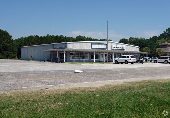
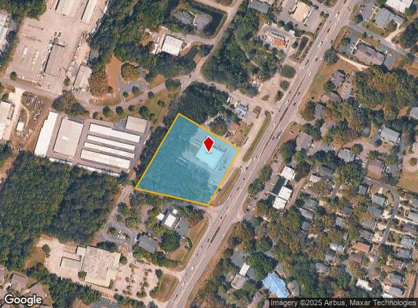
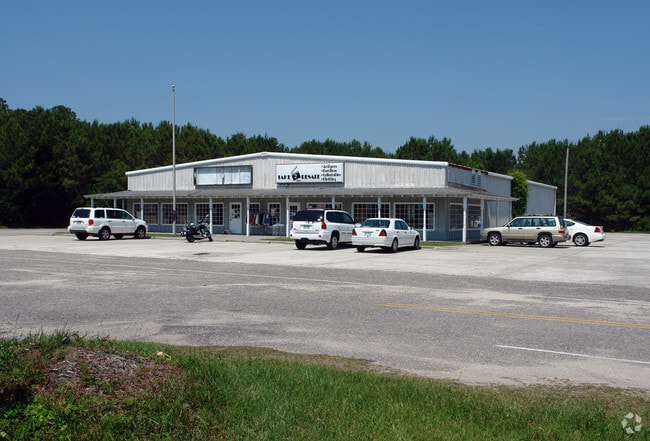
Property Record
11115 Ocean Hwy, Pawleys Island, SC 29585
NEARBY LISTINGS FOR SALE OR LEASE
-
-
View all Pawleys Island listings for sale on LoopNet.com
Property Detail
11115 Ocean Hwy
Georgetown, SC
Papk
04-0155-012-00-00
5 SEC A PAWLEYS PARK ; PLT 3297-34
Commercialnec
Georgetown
AE
South Carolina
45043C0378G
5
2024
2.79 AC
2024
Myrtle Beach South
920507
Other Market Areas
8,000 SF
DEMOGRAPHICS near 11115 Ocean Hwy
1 Mile
3 Mile
5 Mile
2024 Total Population
2,153
15,804
19,546
2029 Population
2,302
16,947
20,998
Pop Growth 2024-2029
+ 6.92%
+ 7.23%
+ 7.43%
Average Age
49
53
53
2024 Total Households
982
7,345
9,003
HH Growth 2024-2029
+ 6.62%
+ 6.97%
+ 7.21%
Median Household Inc
$46,987
$73,383
$78,298
Avg Household Size
2.20
2.10
2.10
2024 Avg HH Vehicles
2.00
2.00
2.00
Median Home Value
$224,146
$354,657
$374,230
Median Year Built
1994
1995
1996
Nearby Places
Map Layers
Map Styles
 Street
 Aerial
- Restaurants
- Banks
- Shops
- Fitness
- Groceries
PUBLIC TRANSPORTATION
AIRPORT
Myrtle Beach International
DRIVE
WALK
Distance
Myrtle Beach International
37 min
24.2 mi
Freight Ports
Wando Welch Terminal
DRIVE
WALK
Distance
Wando Welch Terminal
90 min
66.8 mi
Nearby Properties
Address
Land Use
TOTAL SIZE
Lot Size
Zoning
Address
Land Use
TOTAL SIZE
Lot Size
Zoning
Address
Land Use
TOTAL SIZE
Lot Size
Zoning
35.20 AC
Address
Land Use
TOTAL SIZE
Lot Size
Zoning
19,489 SF
11.49 AC
Address
Land Use
TOTAL SIZE
Lot Size
Zoning
Address
Land Use
TOTAL SIZE
Lot Size
Zoning
Address
Land Use
TOTAL SIZE
Lot Size
Zoning
Address
Land Use
TOTAL SIZE
Lot Size
Zoning
5,897 SF
15.25 AC
Address
Land Use
TOTAL SIZE
Lot Size
Zoning
5,831 SF
116.51 AC
Address
Land Use
TOTAL SIZE
Lot Size
Zoning
30,791 SF
3.50 AC
Address
Land Use
TOTAL SIZE
Lot Size
Zoning
Address
Land Use
TOTAL SIZE
Lot Size
Zoning
12,404 SF
4.70 AC
Address
Land Use
TOTAL SIZE
Lot Size
Zoning
11,250 SF
4.39 AC
Address
Land Use
TOTAL SIZE
Lot Size
Zoning
2,086 SF
22.40 AC
Address
Land Use
TOTAL SIZE
Lot Size
Zoning
Address
Land Use
TOTAL SIZE
Lot Size
Zoning
2,135 SF
20 AC
Address
Land Use
TOTAL SIZE
Lot Size
Zoning
2,606 SF
0.21 AC
Address
Land Use
TOTAL SIZE
Lot Size
Zoning
132,961 SF
12.01 AC
Address
Land Use
TOTAL SIZE
Lot Size
Zoning
Address
Land Use
TOTAL SIZE
Lot Size
Zoning
Address
Land Use
TOTAL SIZE
Lot Size
Zoning
4,802 SF
0.35 AC
Address
Land Use
TOTAL SIZE
Lot Size
Zoning
14.45 AC
Address
Land Use
TOTAL SIZE
Lot Size
Zoning
Address
Land Use
TOTAL SIZE
Lot Size
Zoning
6,735 SF
1.38 AC
Address
Land Use
TOTAL SIZE
Lot Size
Zoning
2,943 SF
1 AC
Address
Land Use
TOTAL SIZE
Lot Size
Zoning
3,699 SF
1 AC
Address
Land Use
TOTAL SIZE
Lot Size
Zoning
2,861 SF
0.56 AC
Address
Land Use
TOTAL SIZE
Lot Size
Zoning
6,240 SF
0.48 AC
Address
Land Use
TOTAL SIZE
Lot Size
Zoning
3,250 SF
1 AC
Address
Land Use
TOTAL SIZE
Lot Size
Zoning
2,748 SF
0.61 AC
The World's #1 Commercial Real Estate Marketplace
Connect with us
© 2025 CoStar Group
The information above has been obtained from sources believed reliable. While we do not doubt its accuracy we have not verified it and make no guarantee, warranty or representation about it. It is your responsibility to independently confirm its accuracy and completeness. Any projections, opinions, assumptions, or estimates used are for example only and do not represent the current or future performance of the property. The value of this transaction to you depends on tax and other factors which should be evaluated by your tax, financial, and legal advisors. You and your advisors should conduct a careful, independent investigation of the property to determine to your satisfaction the suitability of the property for your needs.