Property Record
11116 Sierra Rd, Oakdale, CA 95361


NEARBY LISTINGS FOR SALE OR LEASE
Property Detail
11116 Sierra Rd
Modesto, CA
Oakdale Irrigated Acres Sub-Tr
010-39-48
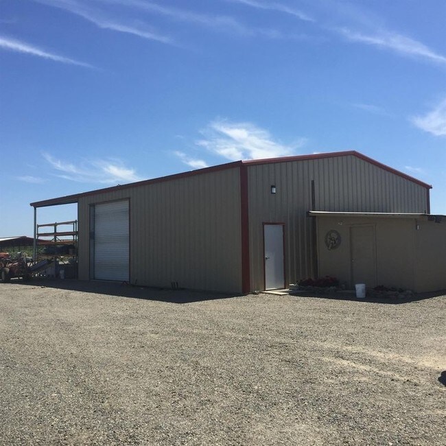
EQUIPMENT & SUPPLIES DD
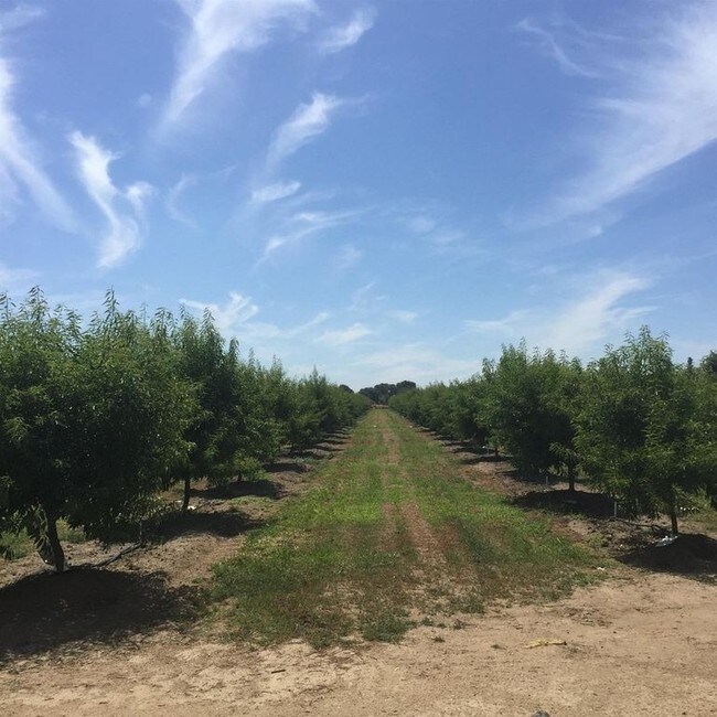
Dairyfarm
Stanislaus
X
California
06099C0195E
20-23
2025
19.61 AC
2025
Hughson/Oakdale/Waterford
000102
Stockton/Modesto
1,152 SF
DEMOGRAPHICS near 11116 Sierra Rd
1 Mile
3 Mile
5 Mile
2024 Total Population
62
9,552
28,772
2029 Population
60
9,564
28,777
Pop Growth 2024-2029
(3.23%)
+ 0.13%
+ 0.02%
Average Age
39
41
39
2024 Total Households
21
3,494
10,280
HH Growth 2024-2029
(4.76%)
+ 0.09%
(0.02%)
Median Household Inc
$99,999
$95,156
$85,791
Avg Household Size
2.70
2.70
2.80
2024 Avg HH Vehicles
3.00
3.00
2.00
Median Home Value
$729,166
$497,748
$458,638
Median Year Built
1991
1995
1987
Nearby Places
Map Layers
Map Styles
 Street
 Aerial
- Restaurants
- Banks
- Shops
- Fitness
- Groceries
PUBLIC TRANSPORTATION
AIRPORT
Stockton Metro
DRIVE
WALK
Distance
Stockton Metro
54 min
30.1 mi
Freight Ports
Port of Stockton
DRIVE
WALK
Distance
Port of Stockton
63 min
41.0 mi
SALE & LEASE HISTORY
LISTING DATE
SALE/LEASE

Nov 27, 2018
For Sale
Nearby Properties
Address
Land Use
TOTAL SIZE
Lot Size
Zoning
Address
Land Use
TOTAL SIZE
Lot Size
Zoning
95,020 SF
9.82 AC
OAKPD
Address
Land Use
TOTAL SIZE
Lot Size
Zoning
45,337 SF
3.97 AC
OAKPSP
Address
Land Use
TOTAL SIZE
Lot Size
Zoning
96,550 SF
4.05 AC
Address
Land Use
TOTAL SIZE
Lot Size
Zoning
11,411 SF
133.33 AC
COURA
Address
Land Use
TOTAL SIZE
Lot Size
Zoning
23,618 SF
2.93 AC
OAKPSP
Address
Land Use
TOTAL SIZE
Lot Size
Zoning
37,998 SF
2.80 AC
Address
Land Use
TOTAL SIZE
Lot Size
Zoning
1.44 AC
OAKLM
Address
Land Use
TOTAL SIZE
Lot Size
Zoning
48,460 SF
5.64 AC
Address
Land Use
TOTAL SIZE
Lot Size
Zoning
78,731 SF
3.91 AC
Address
Land Use
TOTAL SIZE
Lot Size
Zoning
133,627 SF
13.33 AC
Address
Land Use
TOTAL SIZE
Lot Size
Zoning
86,549 SF
7.34 AC
Address
Land Use
TOTAL SIZE
Lot Size
Zoning
34,331 SF
1.70 AC
OAKC2
Address
Land Use
TOTAL SIZE
Lot Size
Zoning
12,861 SF
1.34 AC
OAKC2
Address
Land Use
TOTAL SIZE
Lot Size
Zoning
25,575 SF
4.86 AC
C2
Address
Land Use
TOTAL SIZE
Lot Size
Zoning
816 SF
156.30 AC
A240
Address
Land Use
TOTAL SIZE
Lot Size
Zoning
2,908 SF
316.37 AC
A240
Address
Land Use
TOTAL SIZE
Lot Size
Zoning
50,250 SF
5.26 AC
OAKR2
Address
Land Use
TOTAL SIZE
Lot Size
Zoning
19 AC
A240
Address
Land Use
TOTAL SIZE
Lot Size
Zoning
47,375 SF
2 AC
Address
Land Use
TOTAL SIZE
Lot Size
Zoning
2,456 SF
119.58 AC
A240
Address
Land Use
TOTAL SIZE
Lot Size
Zoning
54,794 SF
3.42 AC
OAKM1
Address
Land Use
TOTAL SIZE
Lot Size
Zoning
39,888 SF
2.22 AC
OAKLM
Address
Land Use
TOTAL SIZE
Lot Size
Zoning
31,945 SF
4.50 AC
Address
Land Use
TOTAL SIZE
Lot Size
Zoning
1,039 SF
753.85 AC
A240
Address
Land Use
TOTAL SIZE
Lot Size
Zoning
23,900 SF
3.23 AC
MI
Address
Land Use
TOTAL SIZE
Lot Size
Zoning
2,126 SF
57.71 AC
A240
Address
Land Use
TOTAL SIZE
Lot Size
Zoning
18,432 SF
1.69 AC
Address
Land Use
TOTAL SIZE
Lot Size
Zoning
22,000 SF
2.05 AC
OAKLM
Address
Land Use
TOTAL SIZE
Lot Size
Zoning
34,272 SF
5.78 AC
C2
Address
Land Use
TOTAL SIZE
Lot Size
Zoning
20,020 SF
2 AC
The World's #1 Commercial Real Estate Marketplace
Connect with us
© 2026 CoStar Group
The information above has been obtained from sources believed reliable. While we do not doubt its accuracy we have not verified it and make no guarantee, warranty or representation about it. It is your responsibility to independently confirm its accuracy and completeness. Any projections, opinions, assumptions, or estimates used are for example only and do not represent the current or future performance of the property. The value of this transaction to you depends on tax and other factors which should be evaluated by your tax, financial, and legal advisors. You and your advisors should conduct a careful, independent investigation of the property to determine to your satisfaction the suitability of the property for your needs.