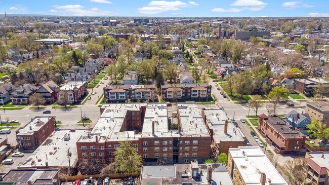
Property Record
11118 Clifton Blvd, Cleveland, OH 44102
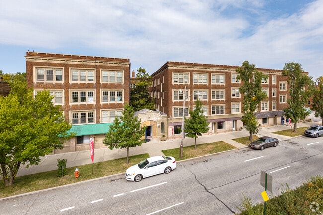
This Property Is For Sale
NEARBY LISTINGS FOR SALE OR LEASE
Property Detail
11118 Clifton Blvd
Cleveland-Elyria, OH
City Of Cleveland
001-19-432
UNIT 11114 OF PLAT AFN 202212220342
Condominium
Cuyahoga
2024
Ohio
2024
0.01 AC
101102
Edgewater
564 SF
Cleveland
DEMOGRAPHICS near 11118 Clifton Blvd
1 Mile
3 Mile
5 Mile
2024 Total Population
21,371
122,814
247,733
2029 Population
20,971
118,913
240,899
Pop Growth 2024-2029
(1.87%)
(3.18%)
(2.76%)
Average Age
40
38
39
2024 Total Households
12,326
57,595
116,477
HH Growth 2024-2029
(1.92%)
(3.20%)
(2.69%)
Median Household Inc
$43,916
$48,109
$50,048
Avg Household Size
1.70
2.00
2.00
2024 Avg HH Vehicles
1.00
1.00
1.00
Median Home Value
$165,552
$160,103
$152,511
Median Year Built
1951
1947
1948
Nearby Places
Map Layers
Map Styles
 Street
 Aerial
- Restaurants
- Banks
- Shops
- Fitness
- Groceries
PUBLIC TRANSPORTATION
TRANSIT/SUBWAY
West Blvd-Cudell Station (Red Line - Greater Cleveland Regional Transit Authority)
DRIVE
WALK
Distance
West Blvd-Cudell Station (Red Line - Greater Cleveland Regional Transit Authority)
2 min
18 min
0.9 mi
West Boulevard - Cudell (Red Line - Greater Cleveland Regional Transit Authority Rapid Transit (The Rapid))
DRIVE
WALK
Distance
West Boulevard - Cudell (Red Line - Greater Cleveland Regional Transit Authority Rapid Transit (The Rapid))
2 min
18 min
0.9 mi
W 117Th St-Madison Av Station (Red Line - Greater Cleveland Regional Transit Authority)
DRIVE
WALK
Distance
W 117Th St-Madison Av Station (Red Line - Greater Cleveland Regional Transit Authority)
3 min
19 min
1.0 mi
West 117 - Madison (Red Line - Greater Cleveland Regional Transit Authority Rapid Transit (The Rapid))
DRIVE
WALK
Distance
West 117 - Madison (Red Line - Greater Cleveland Regional Transit Authority Rapid Transit (The Rapid))
3 min
19 min
1.0 mi
COMMUTER RAIL
Cleveland Lakefront Station (Blue Line - Greater Cleveland Regional Transit Authority Rapid Transit (The Rapid), Green Line - Greater Cleveland Regional Transit Authority Rapid Transit (The Rapid))
DRIVE
WALK
Distance
Cleveland Lakefront Station (Blue Line - Greater Cleveland Regional Transit Authority Rapid Transit (The Rapid), Green Line - Greater Cleveland Regional Transit Authority Rapid Transit (The Rapid))
13 min
5.6 mi
AIRPORT
Cleveland-Hopkins International
DRIVE
WALK
Distance
Cleveland-Hopkins International
21 min
9.3 mi
Freight Ports
Port of Toledo
DRIVE
WALK
Distance
Port of Toledo
133 min
109.7 mi
Nearby Properties
Address
Land Use
TOTAL SIZE
Lot Size
Zoning
Address
Land Use
TOTAL SIZE
Lot Size
Zoning
5,100 SF
9.41 AC
GI
Address
Land Use
TOTAL SIZE
Lot Size
Zoning
518,244 SF
21.80 AC
Address
Land Use
TOTAL SIZE
Lot Size
Zoning
164,294 SF
13.81 AC
GI
Address
Land Use
TOTAL SIZE
Lot Size
Zoning
320,334 SF
4 AC
GR
Address
Land Use
TOTAL SIZE
Lot Size
Zoning
200,874 SF
3.30 AC
LR
Address
Land Use
TOTAL SIZE
Lot Size
Zoning
242,515 SF
1.01 AC
Address
Land Use
TOTAL SIZE
Lot Size
Zoning
308,339 SF
9.78 AC
2F
Address
Land Use
TOTAL SIZE
Lot Size
Zoning
168,750 SF
18.55 AC
GI
Address
Land Use
TOTAL SIZE
Lot Size
Zoning
3.96 AC
Address
Land Use
TOTAL SIZE
Lot Size
Zoning
258,852 SF
5.20 AC
MF2
Address
Land Use
TOTAL SIZE
Lot Size
Zoning
372,786 SF
4.79 AC
MF3+
Address
Land Use
TOTAL SIZE
Lot Size
Zoning
145,936 SF
1.05 AC
2F
Address
Land Use
TOTAL SIZE
Lot Size
Zoning
155,896 SF
5.03 AC
Address
Land Use
TOTAL SIZE
Lot Size
Zoning
616,636 SF
3.28 AC
MF-2
Address
Land Use
TOTAL SIZE
Lot Size
Zoning
59,913 SF
0.92 AC
LR
Address
Land Use
TOTAL SIZE
Lot Size
Zoning
128,902 SF
7.12 AC
PD
Address
Land Use
TOTAL SIZE
Lot Size
Zoning
126,661 SF
7.07 AC
PD
Address
Land Use
TOTAL SIZE
Lot Size
Zoning
56,212 SF
2.69 AC
Address
Land Use
TOTAL SIZE
Lot Size
Zoning
278,256 SF
0.81 AC
C1
Address
Land Use
TOTAL SIZE
Lot Size
Zoning
228,712 SF
10.10 AC
C3
Address
Land Use
TOTAL SIZE
Lot Size
Zoning
64,000 SF
4.05 AC
Address
Land Use
TOTAL SIZE
Lot Size
Zoning
144,307 SF
2.99 AC
MF2
Address
Land Use
TOTAL SIZE
Lot Size
Zoning
105,632 SF
1.01 AC
MF3+
Address
Land Use
TOTAL SIZE
Lot Size
Zoning
57,744 SF
2.30 AC
Address
Land Use
TOTAL SIZE
Lot Size
Zoning
28,852 SF
8.30 AC
Address
Land Use
TOTAL SIZE
Lot Size
Zoning
153,771 SF
1.57 AC
SI
Address
Land Use
TOTAL SIZE
Lot Size
Zoning
155,268 SF
4.86 AC
2F
Address
Land Use
TOTAL SIZE
Lot Size
Zoning
88,468 SF
1.31 AC
LR
Address
Land Use
TOTAL SIZE
Lot Size
Zoning
300,816 SF
7.04 AC
MF-1
Address
Land Use
TOTAL SIZE
Lot Size
Zoning
97,264 SF
4.16 AC
2F
The World's #1 Commercial Real Estate Marketplace
Connect with us
© 2025 CoStar Group
The information above has been obtained from sources believed reliable. While we do not doubt its accuracy we have not verified it and make no guarantee, warranty or representation about it. It is your responsibility to independently confirm its accuracy and completeness. Any projections, opinions, assumptions, or estimates used are for example only and do not represent the current or future performance of the property. The value of this transaction to you depends on tax and other factors which should be evaluated by your tax, financial, and legal advisors. You and your advisors should conduct a careful, independent investigation of the property to determine to your satisfaction the suitability of the property for your needs.