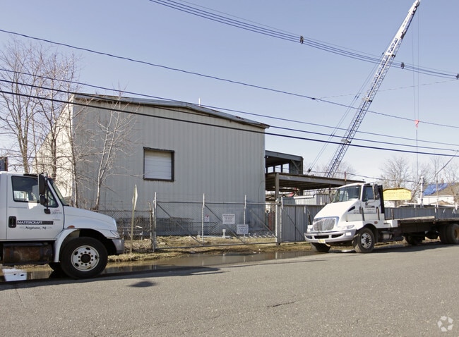
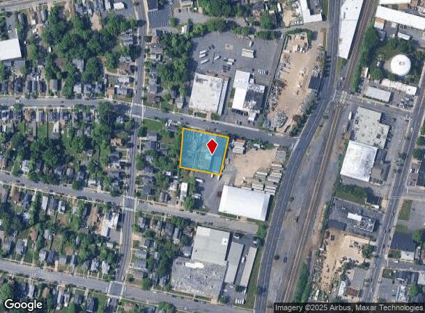
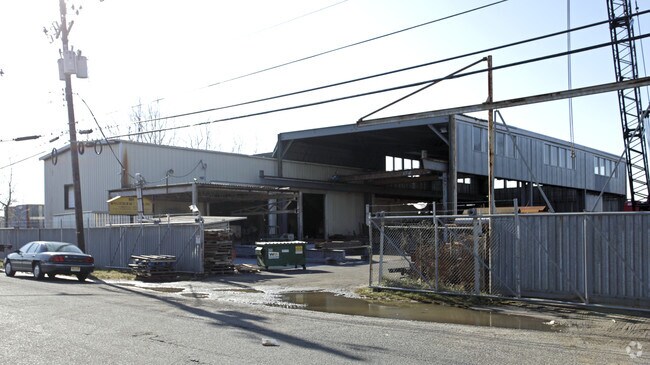
Property Record
1112 11Th Ave, Neptune, NJ 07753
NEARBY LISTINGS FOR SALE OR LEASE
Property Detail
1112 11Th Ave
35-00301-0000-00010
ALSO 105/107 NIT 1A
Industrialgeneral
Monmouth
X
New Jersey
34025C0334G
10
2024
0.72 AC
2025
Eastern Monmouth
807800
Northern New Jersey
5,000 SF
Lakewood-New Brunswick, NJ
DEMOGRAPHICS near 1112 11Th Ave
1 Mile
3 Mile
5 Mile
2024 Total Population
26,192
79,492
138,297
2029 Population
26,622
80,713
140,146
Pop Growth 2024-2029
+ 1.64%
+ 1.54%
+ 1.34%
Average Age
41
43
44
2024 Total Households
11,615
35,062
59,261
HH Growth 2024-2029
+ 2.14%
+ 1.71%
+ 1.28%
Median Household Inc
$65,345
$84,513
$91,942
Avg Household Size
2.10
2.20
2.20
2024 Avg HH Vehicles
1.00
2.00
2.00
Median Home Value
$519,002
$482,543
$526,098
Median Year Built
1953
1960
1968
Nearby Places
Map Layers
Map Styles
 Street
 Aerial
- Restaurants
- Banks
- Shops
- Fitness
- Groceries
PUBLIC TRANSPORTATION
COMMUTER RAIL
Bradley Beach (North Jersey Coast Line - NJ Transit Commuter Rail (NJ Transit))
DRIVE
WALK
Distance
Bradley Beach (North Jersey Coast Line - NJ Transit Commuter Rail (NJ Transit))
1 min
9 min
0.4 mi
Asbury Park (North Jersey Coast Line - NJ Transit Commuter Rail (NJ Transit))
DRIVE
WALK
Distance
Asbury Park (North Jersey Coast Line - NJ Transit Commuter Rail (NJ Transit))
2 min
11 min
0.6 mi
Freight Ports
New York Container Terminal
DRIVE
WALK
Distance
New York Container Terminal
56 min
42.9 mi
Nearby Properties
Address
Land Use
TOTAL SIZE
Lot Size
Zoning
Address
Land Use
TOTAL SIZE
Lot Size
Zoning
26,282 SF
4.59 AC
C
Address
Land Use
TOTAL SIZE
Lot Size
Zoning
5,776 SF
25.50 AC
PB
Address
Land Use
TOTAL SIZE
Lot Size
Zoning
739,651 SF
27.89 AC
C
Address
Land Use
TOTAL SIZE
Lot Size
Zoning
113.60 AC
WBA
Address
Land Use
TOTAL SIZE
Lot Size
Zoning
65,668 SF
111.60 AC
C50
Address
Land Use
TOTAL SIZE
Lot Size
Zoning
320,341 SF
57.85 AC
C
Address
Land Use
TOTAL SIZE
Lot Size
Zoning
32.19 AC
R-7
Address
Land Use
TOTAL SIZE
Lot Size
Zoning
1.61 AC
R1
Address
Land Use
TOTAL SIZE
Lot Size
Zoning
705 SF
2.01 AC
WPRA
Address
Land Use
TOTAL SIZE
Lot Size
Zoning
1,152 SF
87 SF
WPRA
Address
Land Use
TOTAL SIZE
Lot Size
Zoning
108,641 SF
10.64 AC
C-6
Address
Land Use
TOTAL SIZE
Lot Size
Zoning
1,288 SF
25.49 AC
HD-R
Address
Land Use
TOTAL SIZE
Lot Size
Zoning
5,407 SF
25.60 AC
C-3
Address
Land Use
TOTAL SIZE
Lot Size
Zoning
3,094 SF
277.60 AC
C
Address
Land Use
TOTAL SIZE
Lot Size
Zoning
224,683 SF
21.56 AC
CHS
Address
Land Use
TOTAL SIZE
Lot Size
Zoning
91,173 SF
4.07 AC
R3
Address
Land Use
TOTAL SIZE
Lot Size
Zoning
254,714 SF
3.40 AC
WPRA
Address
Land Use
TOTAL SIZE
Lot Size
Zoning
Address
Land Use
TOTAL SIZE
Lot Size
Zoning
1,487 SF
7.50 AC
R-B
Address
Land Use
TOTAL SIZE
Lot Size
Zoning
34,590 SF
18.38 AC
C-2
Address
Land Use
TOTAL SIZE
Lot Size
Zoning
0.88 AC
STNB
Address
Land Use
TOTAL SIZE
Lot Size
Zoning
8.82 AC
R2
Address
Land Use
TOTAL SIZE
Lot Size
Zoning
14,484 SF
163.40 AC
R-1
Address
Land Use
TOTAL SIZE
Lot Size
Zoning
Address
Land Use
TOTAL SIZE
Lot Size
Zoning
27,328 SF
6.79 AC
HB12
Address
Land Use
TOTAL SIZE
Lot Size
Zoning
0.76 AC
R-1
Address
Land Use
TOTAL SIZE
Lot Size
Zoning
7.39 AC
R2
Address
Land Use
TOTAL SIZE
Lot Size
Zoning
8.76 AC
R1
Address
Land Use
TOTAL SIZE
Lot Size
Zoning
86,328 SF
5.96 AC
P4
Address
Land Use
TOTAL SIZE
Lot Size
Zoning
0.34 AC
WPRA
The World's #1 Commercial Real Estate Marketplace
Connect with us
© 2026 CoStar Group
The information above has been obtained from sources believed reliable. While we do not doubt its accuracy we have not verified it and make no guarantee, warranty or representation about it. It is your responsibility to independently confirm its accuracy and completeness. Any projections, opinions, assumptions, or estimates used are for example only and do not represent the current or future performance of the property. The value of this transaction to you depends on tax and other factors which should be evaluated by your tax, financial, and legal advisors. You and your advisors should conduct a careful, independent investigation of the property to determine to your satisfaction the suitability of the property for your needs.