Property Record
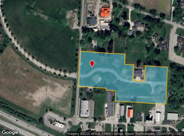
745 Cherry Valley Rd Ne, Newark, OH 43055
NEARBY LISTINGS FOR SALE OR LEASE
Property Detail
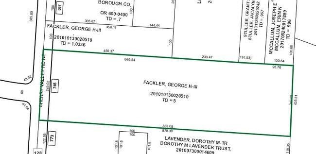
745 Cherry Valley Rd Ne
Columbus, OH
Courtyards At Cherry Valley Condominium
020-042948-00.000
6.375 AC LOT 1 2ND RNG 1ST DIV R13 T2 Q4
Residentialnec
Licking
X
Ohio
39089C0336H
1
2024
6.37 AC
2024
Licking County
753900
Columbus
1,361 SF
DEMOGRAPHICS near 745 Cherry Valley Rd Ne
1 mile
3 mile
5 mile
2024 Total Population
4,444
32,908
70,504
2029 Population
4,637
34,324
73,818
Pop Growth 2024-2029
+ 4.34%
+ 4.30%
+ 4.70%
Average Age
38
41
40
2024 Total Households
1,587
13,004
28,442
HH Growth 2024-2029
+ 4.54%
+ 4.46%
+ 4.79%
Median Household Inc
$106,372
$70,886
$62,501
Avg Household Size
2.60
2.30
2.30
2024 Avg HH Vehicles
2.00
2.00
2.00
Median Home Value
$322,172
$197,922
$172,407
Median Year Built
1986
1970
1968
Nearby Places
Map Layers
Map Styles
 Street
 Aerial
Transit
 Traffic
 Biking
Places
Listings with unknown addresses are not visible on the map
- Restaurants
- Banks
- Shops
- Fitness
- Groceries
PUBLIC TRANSPORTATION
AIRPORT
John Glenn Columbus International
Drive
Walk
Distance
John Glenn Columbus International
39 min
29.2 mi
Rickenbacker International
Drive
Walk
Distance
Rickenbacker International
50 min
36.7 mi
SALE & LEASE HISTORY
LISTING DATE
SALE/LEASE

Sep 24, 2016
For Sale
Nearby Properties
Address
Land Use
TOTAL SIZE
Lot Size
Zoning
Address
Land Use
TOTAL SIZE
Lot Size
Zoning
58,736 SF
125.87 AC
Address
Land Use
TOTAL SIZE
Lot Size
Zoning
212,744 SF
19.16 AC
Address
Land Use
TOTAL SIZE
Lot Size
Zoning
19,176 SF
16.50 AC
Address
Land Use
TOTAL SIZE
Lot Size
Zoning
54,600 SF
101.38 AC
Address
Land Use
TOTAL SIZE
Lot Size
Zoning
750,000 SF
50.61 AC
Address
Land Use
TOTAL SIZE
Lot Size
Zoning
38,400 SF
7.87 AC
Address
Land Use
TOTAL SIZE
Lot Size
Zoning
17,550 SF
7 AC
Address
Land Use
TOTAL SIZE
Lot Size
Zoning
332,516 SF
44.81 AC
Address
Land Use
TOTAL SIZE
Lot Size
Zoning
27,122 SF
1.92 AC
Address
Land Use
TOTAL SIZE
Lot Size
Zoning
68,326 SF
28.51 AC
Address
Land Use
TOTAL SIZE
Lot Size
Zoning
64,828 SF
30 AC
Address
Land Use
TOTAL SIZE
Lot Size
Zoning
18,033 SF
3 AC
Address
Land Use
TOTAL SIZE
Lot Size
Zoning
67,824 SF
16.26 AC
Address
Land Use
TOTAL SIZE
Lot Size
Zoning
3,778 SF
3.78 AC
Address
Land Use
TOTAL SIZE
Lot Size
Zoning
69,782 SF
2.41 AC
Address
Land Use
TOTAL SIZE
Lot Size
Zoning
223,436 SF
19.22 AC
Address
Land Use
TOTAL SIZE
Lot Size
Zoning
19,200 SF
14.56 AC
Address
Land Use
TOTAL SIZE
Lot Size
Zoning
73,269 SF
15.64 AC
Address
Land Use
TOTAL SIZE
Lot Size
Zoning
4,080 SF
12.84 AC
Address
Land Use
TOTAL SIZE
Lot Size
Zoning
92,329 SF
12.86 AC
Address
Land Use
TOTAL SIZE
Lot Size
Zoning
50,482 SF
13.91 AC
Address
Land Use
TOTAL SIZE
Lot Size
Zoning
79,454 SF
19.13 AC
Address
Land Use
TOTAL SIZE
Lot Size
Zoning
56,464 SF
16.75 AC
Address
Land Use
TOTAL SIZE
Lot Size
Zoning
63,635 SF
7.91 AC
Address
Land Use
TOTAL SIZE
Lot Size
Zoning
570,284 SF
56.17 AC
Address
Land Use
TOTAL SIZE
Lot Size
Zoning
34,298 SF
11.40 AC
Address
Land Use
TOTAL SIZE
Lot Size
Zoning
888 SF
14.60 AC
Address
Land Use
TOTAL SIZE
Lot Size
Zoning
34,893 SF
1.16 AC
Address
Land Use
TOTAL SIZE
Lot Size
Zoning
960 SF
56.60 AC
Address
Land Use
TOTAL SIZE
Lot Size
Zoning
135,148 SF
14.94 AC
The World's #1 Commercial Real Estate Marketplace
Connect with us
© 2026 CoStar Group
The information above has been obtained from sources believed reliable. While we do not doubt its accuracy we have not verified it and make no guarantee, warranty or representation about it. It is your responsibility to independently confirm its accuracy and completeness. Any projections, opinions, assumptions, or estimates used are for example only and do not represent the current or future performance of the property. The value of this transaction to you depends on tax and other factors which should be evaluated by your tax, financial, and legal advisors. You and your advisors should conduct a careful, independent investigation of the property to determine to your satisfaction the suitability of the property for your needs.