Property Record
1112 Parkside St, Salinas, CA 93906


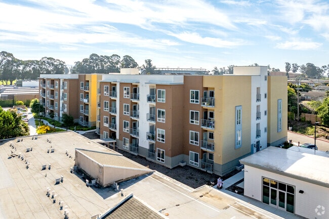
Property Detail
1112 Parkside St
Salinas, CA
VOL 24 PAR MAPS PG 2 PARCEL 1 2.305 AC APPROX
003-773-059-000
MONTEREY
Apartment
California
C and X Area of minimal flood hazard, usually depicted on FIRMs as above the 500-year flood level.
2.30 AC
2024
Greater Salinas
2025
Salinas
000400
NEARBY LISTINGS FOR SALE OR LEASE
DEMOGRAPHICS near 1112 Parkside St
1 mile
3 mile
5 mile
2025 Total Population
29,221
151,803
165,909
2030 Population
29,168
150,287
164,255
Pop Growth 2025-2030
(0.18%)
(1.00%)
(1.00%)
Average Age
35
35
35
2025 Total Households
8,242
40,308
43,480
HH Growth 2025-2030
(0.46%)
(1.23%)
(1.24%)
Median Household Inc
$83,556
$85,018
$85,837
Avg Household Size
3.40
3.60
3.60
2025 Avg HH Vehicles
2.00
2.00
2.00
Median Home Value
$639,103
$669,013
$676,481
Median Year Built
1976
1974
1975
Nearby Places
Map Layers
Map Styles
 Street
 Aerial
Layers
 Traffic
 Biking
Places
Listings with unknown addresses are not visible on the map
- Restaurants
- Banks
- Shops
- Fitness
- Groceries
PUBLIC TRANSPORTATION
COMMUTER RAIL
Salinas (Coast Starlight - Amtrak)
Drive
Walk
Distance
Salinas (Coast Starlight - Amtrak)
5 min
2.3 mi
AIRPORT
Monterey Regional
Drive
Walk
Distance
Monterey Regional
26 min
17.7 mi
Freight Ports
Port of Redwood City
Drive
Walk
Distance
Port of Redwood City
96 min
80.0 mi
Nearby Properties
Address
Land Use
TOTAL SIZE
Lot Size
Zoning
Address
Land Use
TOTAL SIZE
Lot Size
Zoning
1.28 AC
Address
Land Use
TOTAL SIZE
Lot Size
Zoning
230,236 SF
15.57 AC
Address
Land Use
TOTAL SIZE
Lot Size
Zoning
1.21 AC
Address
Land Use
TOTAL SIZE
Lot Size
Zoning
32.88 AC
Address
Land Use
TOTAL SIZE
Lot Size
Zoning
4.37 AC
Address
Land Use
TOTAL SIZE
Lot Size
Zoning
13.86 AC
Address
Land Use
TOTAL SIZE
Lot Size
Zoning
156,370 SF
58.55 AC
Address
Land Use
TOTAL SIZE
Lot Size
Zoning
115,480 SF
12.31 AC
Address
Land Use
TOTAL SIZE
Lot Size
Zoning
181,089 SF
11 AC
Address
Land Use
TOTAL SIZE
Lot Size
Zoning
75,772 SF
2.04 AC
Address
Land Use
TOTAL SIZE
Lot Size
Zoning
0.09 AC
Address
Land Use
TOTAL SIZE
Lot Size
Zoning
14,960 SF
16.02 AC
Address
Land Use
TOTAL SIZE
Lot Size
Zoning
193,480 SF
16.27 AC
Address
Land Use
TOTAL SIZE
Lot Size
Zoning
1.37 AC
Address
Land Use
TOTAL SIZE
Lot Size
Zoning
76,737 SF
3.36 AC
Address
Land Use
TOTAL SIZE
Lot Size
Zoning
1.97 AC
Address
Land Use
TOTAL SIZE
Lot Size
Zoning
89,770 SF
10 AC
Address
Land Use
TOTAL SIZE
Lot Size
Zoning
9.80 AC
Address
Land Use
TOTAL SIZE
Lot Size
Zoning
162,297 SF
12 AC
Address
Land Use
TOTAL SIZE
Lot Size
Zoning
112,816 SF
9.91 AC
Address
Land Use
TOTAL SIZE
Lot Size
Zoning
8.10 AC
Address
Land Use
TOTAL SIZE
Lot Size
Zoning
Address
Land Use
TOTAL SIZE
Lot Size
Zoning
118,797 SF
8.83 AC
Address
Land Use
TOTAL SIZE
Lot Size
Zoning
1,000 SF
1.05 AC
Address
Land Use
TOTAL SIZE
Lot Size
Zoning
3.96 AC
Address
Land Use
TOTAL SIZE
Lot Size
Zoning
70,391 SF
2.46 AC
Address
Land Use
TOTAL SIZE
Lot Size
Zoning
187,259 SF
16.82 AC
Address
Land Use
TOTAL SIZE
Lot Size
Zoning
122,700 SF
9.53 AC
Address
Land Use
TOTAL SIZE
Lot Size
Zoning
130,970 SF
10.56 AC
The World's #1 Commercial Real Estate Marketplace
Connect with us
© 2026 CoStar Group
The information above has been obtained from sources believed reliable. While we do not doubt its accuracy we have not verified it and make no guarantee, warranty or representation about it. It is your responsibility to independently confirm its accuracy and completeness. Any projections, opinions, assumptions, or estimates used are for example only and do not represent the current or future performance of the property. The value of this transaction to you depends on tax and other factors which should be evaluated by your tax, financial, and legal advisors. You and your advisors should conduct a careful, independent investigation of the property to determine to your satisfaction the suitability of the property for your needs.