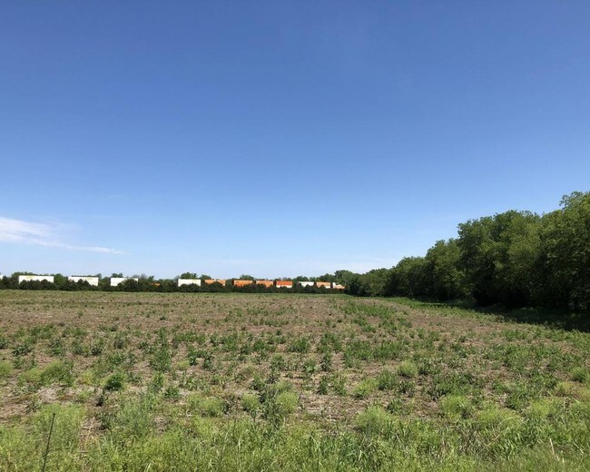
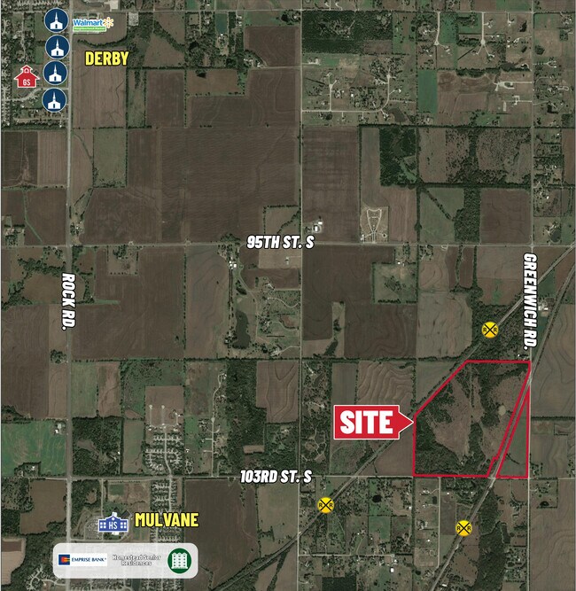
Property Record
11120 E 103Rd St S, Mulvane, KS 67110

Property Detail
11120 E 103Rd St S
235-21-0-41-00-001.00
BEG SE COR SE 1/4 TH N ALG E LI 2062.92 FT TO S RR ROW TH SWLY ALG RR ROW 878.18 FT TH SWLY ALG RR ROW 503.51 FT TH SWLY ALG RR ROW & ALG CUR TO RIGHT 805.37 FT TO S LI SE 1/4 TH E 723.58 FT TO POB & EXC ROW SEC 21-29-2E
Farms
SEDGWICK
RR
Kansas
AE The base floodplain where base flood elevations are provided. AE Zones are now used on new format FIRMs instead of A1-A30 Zones.
0.32 AC
2024
Derby/Haysville/Mulvane
2025
Wichita
009902
Wichita, KS
6,657 SF
NEARBY LISTINGS FOR SALE OR LEASE
-
-
View all Mulvane listings for sale on LoopNet.com
DEMOGRAPHICS near 11120 E 103Rd St S
1 mile
3 mile
5 mile
2025 Total Population
133
9,925
29,022
2030 Population
137
10,072
29,391
Pop Growth 2025-2030
+ 3.01%
+ 1.48%
+ 1.27%
Average Age
42
40
40
2025 Total Households
48
3,628
11,192
HH Growth 2025-2030
+ 2.08%
+ 1.60%
+ 1.13%
Median Household Inc
$108,750
$90,568
$84,175
Avg Household Size
2.80
2.70
2.50
2025 Avg HH Vehicles
3.00
2.00
2.00
Median Home Value
$374,999
$226,445
$230,364
Median Year Built
1985
1985
1986
Nearby Places
Map Layers
Map Styles
 Street
 Aerial
Layers
 Traffic
 Biking
Places
Listings with unknown addresses are not visible on the map
- Restaurants
- Banks
- Shops
- Fitness
- Groceries
PUBLIC TRANSPORTATION
AIRPORT
Wichita Dwight D Eisenhower Ntl
Drive
Walk
Distance
Wichita Dwight D Eisenhower Ntl
40 min
23.2 mi
Freight Ports
Tulsa Port Of Catoosa
Drive
Walk
Distance
Tulsa Port Of Catoosa
204 min
186.3 mi
SALE & LEASE HISTORY
LISTING DATE
SALE/LEASE

Nov 19, 2019
For Sale
May 29, 2020
For Sale
Jun 20, 2019
For Sale
Nearby Properties
Address
Land Use
TOTAL SIZE
Lot Size
Zoning
Address
Land Use
TOTAL SIZE
Lot Size
Zoning
138,281 SF
60.34 AC
Address
Land Use
TOTAL SIZE
Lot Size
Zoning
189,092 SF
35.98 AC
Address
Land Use
TOTAL SIZE
Lot Size
Zoning
127,266 SF
20.04 AC
Address
Land Use
TOTAL SIZE
Lot Size
Zoning
64,858 SF
11.39 AC
R1
Address
Land Use
TOTAL SIZE
Lot Size
Zoning
39,304 SF
2.80 AC
Address
Land Use
TOTAL SIZE
Lot Size
Zoning
35,032 SF
12.62 AC
I1
Address
Land Use
TOTAL SIZE
Lot Size
Zoning
14,026 SF
1.61 AC
Address
Land Use
TOTAL SIZE
Lot Size
Zoning
178,675 SF
Address
Land Use
TOTAL SIZE
Lot Size
Zoning
30,610 SF
3.46 AC
Address
Land Use
TOTAL SIZE
Lot Size
Zoning
28,000 SF
5.50 AC
Address
Land Use
TOTAL SIZE
Lot Size
Zoning
24,900 SF
4.30 AC
Address
Land Use
TOTAL SIZE
Lot Size
Zoning
9,567 SF
4.01 AC
Address
Land Use
TOTAL SIZE
Lot Size
Zoning
3,381 SF
56.91 AC
AA
Address
Land Use
TOTAL SIZE
Lot Size
Zoning
17,548 SF
Address
Land Use
TOTAL SIZE
Lot Size
Zoning
17,047 SF
1.30 AC
Address
Land Use
TOTAL SIZE
Lot Size
Zoning
10,600 SF
4.90 AC
RR
Address
Land Use
TOTAL SIZE
Lot Size
Zoning
600 SF
Address
Land Use
TOTAL SIZE
Lot Size
Zoning
3,464 SF
1.90 AC
Address
Land Use
TOTAL SIZE
Lot Size
Zoning
14,095 SF
0.67 AC
Address
Land Use
TOTAL SIZE
Lot Size
Zoning
6,400 SF
5.34 AC
R1
Address
Land Use
TOTAL SIZE
Lot Size
Zoning
11,498 SF
1 AC
Address
Land Use
TOTAL SIZE
Lot Size
Zoning
4,290 SF
4.80 AC
Address
Land Use
TOTAL SIZE
Lot Size
Zoning
4,254 SF
2.13 AC
R
Address
Land Use
TOTAL SIZE
Lot Size
Zoning
9,760 SF
3.55 AC
R1
Address
Land Use
TOTAL SIZE
Lot Size
Zoning
41,989 SF
6.18 AC
B3
Address
Land Use
TOTAL SIZE
Lot Size
Zoning
15,580 SF
4.91 AC
Address
Land Use
TOTAL SIZE
Lot Size
Zoning
25.37 AC
I1
Address
Land Use
TOTAL SIZE
Lot Size
Zoning
5,160 SF
3.86 AC
Address
Land Use
TOTAL SIZE
Lot Size
Zoning
21,692 SF
5.64 AC
Address
Land Use
TOTAL SIZE
Lot Size
Zoning
9,600 SF
9.16 AC
The World's #1 Commercial Real Estate Marketplace
Connect with us
© 2026 CoStar Group
The information above has been obtained from sources believed reliable. While we do not doubt its accuracy we have not verified it and make no guarantee, warranty or representation about it. It is your responsibility to independently confirm its accuracy and completeness. Any projections, opinions, assumptions, or estimates used are for example only and do not represent the current or future performance of the property. The value of this transaction to you depends on tax and other factors which should be evaluated by your tax, financial, and legal advisors. You and your advisors should conduct a careful, independent investigation of the property to determine to your satisfaction the suitability of the property for your needs.