Property Record
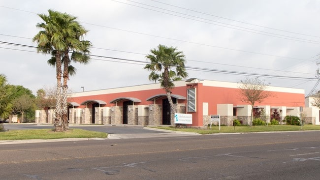
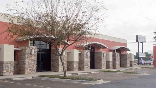
1113 Central Blvd, Brownsville, TX 78520

Property Detail
1113 Central Blvd
Brownsville-Harlingen, TX
BROWNSVILLE - MACRODE NO 2 SUBD LOT 2 BLK 2
079814-0020-002000
Cameron
Commercialnec
Texas
A Areas with a 1% annual chance of flooding and a 26% chance of flooding over the life of a 30-year mortgage.
2
2024
0.95 AC
2025
Downtown Brownsville
013600
Brownsville/Harlingen
12,640 SF
NEARBY LISTINGS FOR SALE OR LEASE
DEMOGRAPHICS near 1113 Central Blvd
1 mile
3 mile
5 mile
2025 Total Population
12,456
78,279
157,968
2030 Population
12,704
79,711
160,786
Pop Growth 2025-2030
+ 1.99%
+ 1.83%
+ 1.78%
Average Age
39
37
37
2025 Total Households
4,352
25,928
49,659
HH Growth 2025-2030
+ 2.09%
+ 1.81%
+ 1.86%
Median Household Inc
$45,604
$44,787
$49,023
Avg Household Size
2.70
2.90
3.10
2025 Avg HH Vehicles
2.00
2.00
2.00
Median Home Value
$107,207
$136,150
$142,294
Median Year Built
1969
1984
1991
Nearby Places
Map Layers
Map Styles
 Street
 Aerial
Layers
 Traffic
 Biking
Places
Listings with unknown addresses are not visible on the map
- Restaurants
- Banks
- Shops
- Fitness
- Groceries
PUBLIC TRANSPORTATION
AIRPORT
Brownsville/South Padre Island International
Drive
Walk
Distance
Brownsville/South Padre Island International
11 min
5.7 mi
Valley International
Drive
Walk
Distance
Valley International
44 min
27.1 mi
SALE & LEASE HISTORY
LISTING DATE
SALE/LEASE

Sep 25, 2016
For Lease
Oct 18, 2022
For Lease
Nearby Properties
Address
Land Use
TOTAL SIZE
Lot Size
Zoning
Address
Land Use
TOTAL SIZE
Lot Size
Zoning
591,279 SF
49.02 AC
Address
Land Use
TOTAL SIZE
Lot Size
Zoning
319,798 SF
46.28 AC
Address
Land Use
TOTAL SIZE
Lot Size
Zoning
452,559 SF
13.79 AC
C
Address
Land Use
TOTAL SIZE
Lot Size
Zoning
363,515 SF
34.39 AC
Address
Land Use
TOTAL SIZE
Lot Size
Zoning
302,902 SF
6.61 AC
C
Address
Land Use
TOTAL SIZE
Lot Size
Zoning
277,742 SF
31.28 AC
Address
Land Use
TOTAL SIZE
Lot Size
Zoning
72,436 SF
22.08 AC
Address
Land Use
TOTAL SIZE
Lot Size
Zoning
66,340 SF
3.85 AC
C
Address
Land Use
TOTAL SIZE
Lot Size
Zoning
167,653 SF
5.10 AC
Address
Land Use
TOTAL SIZE
Lot Size
Zoning
132,197 SF
10.70 AC
Address
Land Use
TOTAL SIZE
Lot Size
Zoning
56,804 SF
1.83 AC
Address
Land Use
TOTAL SIZE
Lot Size
Zoning
73,090 SF
3.08 AC
C
Address
Land Use
TOTAL SIZE
Lot Size
Zoning
148,781 SF
10.28 AC
B
Address
Land Use
TOTAL SIZE
Lot Size
Zoning
213,521 SF
38.75 AC
Address
Land Use
TOTAL SIZE
Lot Size
Zoning
60,747 SF
2.59 AC
C
Address
Land Use
TOTAL SIZE
Lot Size
Zoning
188,446 SF
18.42 AC
Address
Land Use
TOTAL SIZE
Lot Size
Zoning
62,344 SF
2.92 AC
Address
Land Use
TOTAL SIZE
Lot Size
Zoning
98,006 SF
20.30 AC
Address
Land Use
TOTAL SIZE
Lot Size
Zoning
133,476 SF
8.14 AC
Address
Land Use
TOTAL SIZE
Lot Size
Zoning
107,815 SF
10 AC
Address
Land Use
TOTAL SIZE
Lot Size
Zoning
52,668 SF
2.23 AC
Address
Land Use
TOTAL SIZE
Lot Size
Zoning
142,385 SF
0.50 AC
Address
Land Use
TOTAL SIZE
Lot Size
Zoning
102,042 SF
8.68 AC
C
Address
Land Use
TOTAL SIZE
Lot Size
Zoning
176,990 SF
18.31 AC
C
Address
Land Use
TOTAL SIZE
Lot Size
Zoning
110,431 SF
15 AC
Address
Land Use
TOTAL SIZE
Lot Size
Zoning
80,480 SF
10.68 AC
Address
Land Use
TOTAL SIZE
Lot Size
Zoning
101,569 SF
1.95 AC
Address
Land Use
TOTAL SIZE
Lot Size
Zoning
241,619 SF
14.68 AC
Address
Land Use
TOTAL SIZE
Lot Size
Zoning
174,826 SF
5.82 AC
The World's #1 Commercial Real Estate Marketplace
Connect with us
© 2026 CoStar Group
The information above has been obtained from sources believed reliable. While we do not doubt its accuracy we have not verified it and make no guarantee, warranty or representation about it. It is your responsibility to independently confirm its accuracy and completeness. Any projections, opinions, assumptions, or estimates used are for example only and do not represent the current or future performance of the property. The value of this transaction to you depends on tax and other factors which should be evaluated by your tax, financial, and legal advisors. You and your advisors should conduct a careful, independent investigation of the property to determine to your satisfaction the suitability of the property for your needs.