Property Record
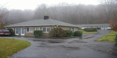
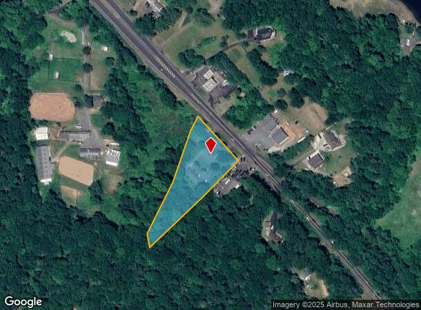
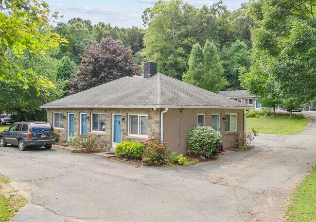
1113 Portland Cobalt Rd, Portland, CT 06480
NEARBY LISTINGS FOR SALE OR LEASE
-
-
View all Portland listings for sale on LoopNet.com
Property Detail
1113 Portland Cobalt Rd
Apartmenthouse5plusunits
Middlesex
X
Connecticut
09007C0128G
1.55 AC
2024
East Hampton/Portland
2025
Hartford
560100
Hartford-West Hartford-East Hartford, CT
1,633 SF
PORT-000023-000000-000006
DEMOGRAPHICS near 1113 Portland Cobalt Rd
1 Mile
3 Mile
5 Mile
2024 Total Population
711
19,036
57,097
2029 Population
714
18,896
56,649
Pop Growth 2024-2029
+ 0.42%
(0.74%)
(0.78%)
Average Age
43
41
42
2024 Total Households
283
7,732
23,444
HH Growth 2024-2029
0.00%
(0.62%)
(0.72%)
Median Household Inc
$134,558
$77,306
$84,197
Avg Household Size
2.50
2.20
2.20
2024 Avg HH Vehicles
2.00
2.00
2.00
Median Home Value
$330,120
$254,510
$268,257
Median Year Built
1965
1951
1963
Nearby Places
Map Layers
Map Styles
 Street
 Aerial
- Restaurants
- Banks
- Shops
- Fitness
- Groceries
PUBLIC TRANSPORTATION
AIRPORT
Tweed/New Haven
DRIVE
WALK
Distance
Tweed/New Haven
48 min
33.6 mi
Bradley International
DRIVE
WALK
Distance
Bradley International
56 min
36.5 mi
Freight Ports
Port of New Haven
DRIVE
WALK
Distance
Port of New Haven
44 min
31.3 mi
SALE & LEASE HISTORY
LISTING DATE
SALE/LEASE

Sep 23, 2016
For Sale
Apr 11, 2025
For Sale
Nearby Properties
Address
Land Use
TOTAL SIZE
Lot Size
Zoning
Address
Land Use
TOTAL SIZE
Lot Size
Zoning
32 AC
R-45
Address
Land Use
TOTAL SIZE
Lot Size
Zoning
65.89 AC
R-45
Address
Land Use
TOTAL SIZE
Lot Size
Zoning
105 AC
R-45
Address
Land Use
TOTAL SIZE
Lot Size
Zoning
0.56 AC
B-1
Address
Land Use
TOTAL SIZE
Lot Size
Zoning
35.14 AC
R-30
Address
Land Use
TOTAL SIZE
Lot Size
Zoning
10.10 AC
IND
Address
Land Use
TOTAL SIZE
Lot Size
Zoning
3.58 AC
DVD
Address
Land Use
TOTAL SIZE
Lot Size
Zoning
102,239 SF
1.02 AC
B-1
Address
Land Use
TOTAL SIZE
Lot Size
Zoning
63.50 AC
I-3
Address
Land Use
TOTAL SIZE
Lot Size
Zoning
15.26 AC
MX
Address
Land Use
TOTAL SIZE
Lot Size
Zoning
14.29 AC
MXC
Address
Land Use
TOTAL SIZE
Lot Size
Zoning
18.50 AC
MXI
Address
Land Use
TOTAL SIZE
Lot Size
Zoning
45,934 SF
7.60 AC
RPZ
Address
Land Use
TOTAL SIZE
Lot Size
Zoning
177,765 SF
1.10 AC
B-1
Address
Land Use
TOTAL SIZE
Lot Size
Zoning
77,786 SF
6.57 AC
B-2
Address
Land Use
TOTAL SIZE
Lot Size
Zoning
11.53 AC
M
Address
Land Use
TOTAL SIZE
Lot Size
Zoning
19,161 SF
0.82 AC
DVD
Address
Land Use
TOTAL SIZE
Lot Size
Zoning
110,708 SF
2.99 AC
MXC
Address
Land Use
TOTAL SIZE
Lot Size
Zoning
32,640 SF
1.80 AC
B-1
Address
Land Use
TOTAL SIZE
Lot Size
Zoning
19,258 SF
1.11 AC
IRA
Address
Land Use
TOTAL SIZE
Lot Size
Zoning
64.70 AC
R-45
Address
Land Use
TOTAL SIZE
Lot Size
Zoning
26,736 SF
0.46 AC
MXC
Address
Land Use
TOTAL SIZE
Lot Size
Zoning
Address
Land Use
TOTAL SIZE
Lot Size
Zoning
35,866 SF
1.61 AC
B-1
Address
Land Use
TOTAL SIZE
Lot Size
Zoning
70,406 SF
0.73 AC
B-1
Address
Land Use
TOTAL SIZE
Lot Size
Zoning
94,097 SF
2.22 AC
B-1
Address
Land Use
TOTAL SIZE
Lot Size
Zoning
26,662 SF
6.50 AC
MXC
Address
Land Use
TOTAL SIZE
Lot Size
Zoning
40,327 SF
4.16 AC
M
Address
Land Use
TOTAL SIZE
Lot Size
Zoning
53,415 SF
1.48 AC
MXC
Address
Land Use
TOTAL SIZE
Lot Size
Zoning
40.82 AC
R15
The World's #1 Commercial Real Estate Marketplace
Connect with us
© 2025 CoStar Group
The information above has been obtained from sources believed reliable. While we do not doubt its accuracy we have not verified it and make no guarantee, warranty or representation about it. It is your responsibility to independently confirm its accuracy and completeness. Any projections, opinions, assumptions, or estimates used are for example only and do not represent the current or future performance of the property. The value of this transaction to you depends on tax and other factors which should be evaluated by your tax, financial, and legal advisors. You and your advisors should conduct a careful, independent investigation of the property to determine to your satisfaction the suitability of the property for your needs.