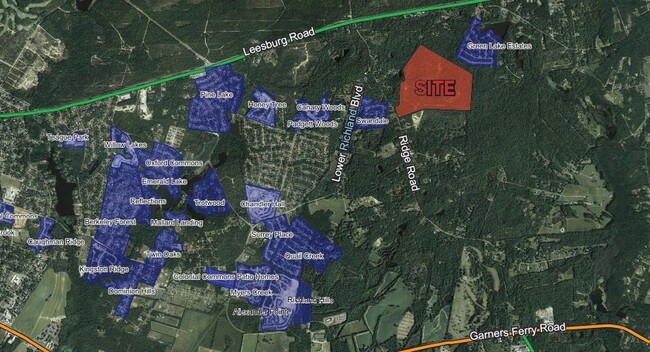
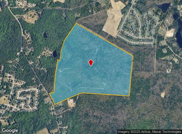
Property Record
1113 Ridge Rd, Hopkins, SC 29061
NEARBY LISTINGS FOR SALE OR LEASE
Property Detail
1113 Ridge Rd
Columbia, SC
Homestead Park
24900-07-03
PARCELS A & C #PR RB1284-730
Agriculturalland
Richland
X
South Carolina
45079C0405L
189.18 AC
2025
Southeast Columbia
2024
Columbia
011902
DEMOGRAPHICS near 1113 Ridge Rd
1 Mile
3 Mile
5 Mile
2024 Total Population
2,019
14,143
34,302
2029 Population
2,072
14,334
35,033
Pop Growth 2024-2029
+ 2.63%
+ 1.35%
+ 2.13%
Average Age
40
40
38
2024 Total Households
787
5,550
13,014
HH Growth 2024-2029
+ 2.67%
+ 1.41%
+ 2.03%
Median Household Inc
$62,296
$60,335
$58,378
Avg Household Size
2.50
2.50
2.40
2024 Avg HH Vehicles
2.00
2.00
2.00
Median Home Value
$167,633
$157,518
$166,430
Median Year Built
1991
1990
1989
Nearby Places
Map Layers
Map Styles
 Street
 Aerial
- Restaurants
- Banks
- Shops
- Fitness
- Groceries
PUBLIC TRANSPORTATION
AIRPORT
Columbia Metro
DRIVE
WALK
Distance
Columbia Metro
40 min
22.3 mi
Freight Ports
North Charleston Terminal
DRIVE
WALK
Distance
North Charleston Terminal
134 min
113.7 mi
Nearby Properties
Address
Land Use
TOTAL SIZE
Lot Size
Zoning
Address
Land Use
TOTAL SIZE
Lot Size
Zoning
51,516 SF
9.12 AC
GC
Address
Land Use
TOTAL SIZE
Lot Size
Zoning
58,000 SF
5.73 AC
C-3
Address
Land Use
TOTAL SIZE
Lot Size
Zoning
84,212 SF
6.88 AC
RG-1A
Address
Land Use
TOTAL SIZE
Lot Size
Zoning
34,900 SF
20 AC
PDD
Address
Land Use
TOTAL SIZE
Lot Size
Zoning
61,682 SF
4.92 AC
C-3
Address
Land Use
TOTAL SIZE
Lot Size
Zoning
19,465 SF
4.41 AC
RU
Address
Land Use
TOTAL SIZE
Lot Size
Zoning
25,184 SF
31 AC
M-1
Address
Land Use
TOTAL SIZE
Lot Size
Zoning
7,642 SF
2.42 AC
GC
Address
Land Use
TOTAL SIZE
Lot Size
Zoning
12,438 SF
8.02 AC
RS-LD
Address
Land Use
TOTAL SIZE
Lot Size
Zoning
10,868 SF
1.79 AC
GC
Address
Land Use
TOTAL SIZE
Lot Size
Zoning
8,263 SF
1.39 AC
GC
Address
Land Use
TOTAL SIZE
Lot Size
Zoning
16,460 SF
3.15 AC
RSF-3
Address
Land Use
TOTAL SIZE
Lot Size
Zoning
5,664 SF
1.47 AC
GC
Address
Land Use
TOTAL SIZE
Lot Size
Zoning
8,760 SF
0.97 AC
GC
Address
Land Use
TOTAL SIZE
Lot Size
Zoning
6,575 SF
2.06 AC
GC
Address
Land Use
TOTAL SIZE
Lot Size
Zoning
48.92 AC
RM-MD
Address
Land Use
TOTAL SIZE
Lot Size
Zoning
204.44 AC
RU
Address
Land Use
TOTAL SIZE
Lot Size
Zoning
15,000 SF
17 AC
M-1
Address
Land Use
TOTAL SIZE
Lot Size
Zoning
19.15 AC
PDD
Address
Land Use
TOTAL SIZE
Lot Size
Zoning
6,208 SF
3.30 AC
RU
Address
Land Use
TOTAL SIZE
Lot Size
Zoning
3,566 SF
1.83 AC
RU
Address
Land Use
TOTAL SIZE
Lot Size
Zoning
7,976 SF
1.01 AC
C-2
Address
Land Use
TOTAL SIZE
Lot Size
Zoning
10,440 SF
1.59 AC
GC
Address
Land Use
TOTAL SIZE
Lot Size
Zoning
5,605 SF
1.02 AC
RU
Address
Land Use
TOTAL SIZE
Lot Size
Zoning
5,605 SF
3 AC
RS-MD
Address
Land Use
TOTAL SIZE
Lot Size
Zoning
5,564 SF
0.65 AC
C-2
Address
Land Use
TOTAL SIZE
Lot Size
Zoning
2,306 SF
1 AC
RS-LD
Address
Land Use
TOTAL SIZE
Lot Size
Zoning
4,516 SF
2.73 AC
RS-MD
Address
Land Use
TOTAL SIZE
Lot Size
Zoning
4,098 SF
1.99 AC
RU
Address
Land Use
TOTAL SIZE
Lot Size
Zoning
5,231 SF
0.46 AC
C-2
The World's #1 Commercial Real Estate Marketplace
Connect with us
© 2025 CoStar Group
The information above has been obtained from sources believed reliable. While we do not doubt its accuracy we have not verified it and make no guarantee, warranty or representation about it. It is your responsibility to independently confirm its accuracy and completeness. Any projections, opinions, assumptions, or estimates used are for example only and do not represent the current or future performance of the property. The value of this transaction to you depends on tax and other factors which should be evaluated by your tax, financial, and legal advisors. You and your advisors should conduct a careful, independent investigation of the property to determine to your satisfaction the suitability of the property for your needs.