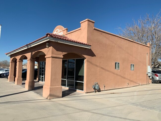
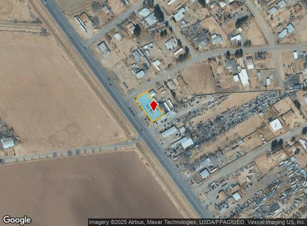
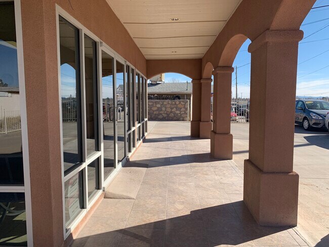
Property Record
11131 Alameda Ave, Socorro, TX 79927
NEARBY LISTINGS FOR SALE OR LEASE
-
-
View all Socorro listings for sale on LoopNet.com
Property Detail
11131 Alameda Ave
El Paso
Aldama Estates
El Paso, TX
6 ALDAMA ESTATES LOT 1 (20000 SQ FT)
A460-000-0060-0010
El Paso
Commercialnec
Texas
2024
1
2025
0.46 AC
010408
Outlying El Paso County
858 SF
DEMOGRAPHICS near 11131 Alameda Ave
1 mile
3 mile
5 mile
2024 Total Population
4,305
43,446
90,600
2029 Population
4,349
44,229
91,630
Pop Growth 2024-2029
+ 1.02%
+ 1.80%
+ 1.14%
Average Age
38
36
35
2024 Total Households
1,332
13,066
27,024
HH Growth 2024-2029
+ 1.05%
+ 1.75%
+ 1.11%
Median Household Inc
$35,333
$42,528
$45,654
Avg Household Size
3.20
3.30
3.30
2024 Avg HH Vehicles
2.00
2.00
2.00
Median Home Value
$119,018
$121,969
$122,640
Median Year Built
1987
1995
1996
Nearby Places
Map Layers
Map Styles
 Street
 Aerial
Transit
 Traffic
 Biking
Places
Listings with unknown addresses are not visible on the map
- Restaurants
- Banks
- Shops
- Fitness
- Groceries
PUBLIC TRANSPORTATION
AIRPORT
El Paso International
Drive
Walk
Distance
El Paso International
33 min
17.6 mi
SALE & LEASE HISTORY
LISTING DATE
SALE/LEASE

Jan 14, 2020
For Sale
Nearby Properties
Address
Land Use
TOTAL SIZE
Lot Size
Zoning
Address
Land Use
TOTAL SIZE
Lot Size
Zoning
393,206 SF
66.48 AC
SU
Address
Land Use
TOTAL SIZE
Lot Size
Zoning
953,000 SF
45.97 AC
M2
Address
Land Use
TOTAL SIZE
Lot Size
Zoning
392,214 SF
29.67 AC
Address
Land Use
TOTAL SIZE
Lot Size
Zoning
618,222 SF
25.18 AC
M2
Address
Land Use
TOTAL SIZE
Lot Size
Zoning
127,840 SF
17.66 AC
Address
Land Use
TOTAL SIZE
Lot Size
Zoning
253,144 SF
3 AC
C2
Address
Land Use
TOTAL SIZE
Lot Size
Zoning
450,900 SF
20.46 AC
M2
Address
Land Use
TOTAL SIZE
Lot Size
Zoning
475,547 SF
26.82 AC
Address
Land Use
TOTAL SIZE
Lot Size
Zoning
156,914 SF
10.37 AC
Address
Land Use
TOTAL SIZE
Lot Size
Zoning
84,207 SF
20 AC
Address
Land Use
TOTAL SIZE
Lot Size
Zoning
308,142 SF
23.54 AC
NZ
Address
Land Use
TOTAL SIZE
Lot Size
Zoning
19,227 SF
24.06 AC
Address
Land Use
TOTAL SIZE
Lot Size
Zoning
138,279 SF
17.42 AC
Address
Land Use
TOTAL SIZE
Lot Size
Zoning
38,909 SF
37.07 AC
Address
Land Use
TOTAL SIZE
Lot Size
Zoning
85,524 SF
12 AC
Address
Land Use
TOTAL SIZE
Lot Size
Zoning
242,991 SF
8.81 AC
M2
Address
Land Use
TOTAL SIZE
Lot Size
Zoning
38,628 SF
11.21 AC
Address
Land Use
TOTAL SIZE
Lot Size
Zoning
77,284 SF
12.75 AC
Address
Land Use
TOTAL SIZE
Lot Size
Zoning
45,091 SF
5.25 AC
Address
Land Use
TOTAL SIZE
Lot Size
Zoning
35,577 SF
4.75 AC
C3
Address
Land Use
TOTAL SIZE
Lot Size
Zoning
85,718 SF
20 AC
Address
Land Use
TOTAL SIZE
Lot Size
Zoning
49,037 SF
24.91 AC
C2
Address
Land Use
TOTAL SIZE
Lot Size
Zoning
202.01 AC
Address
Land Use
TOTAL SIZE
Lot Size
Zoning
71,400 SF
4.27 AC
Address
Land Use
TOTAL SIZE
Lot Size
Zoning
101.05 AC
M1
Address
Land Use
TOTAL SIZE
Lot Size
Zoning
30,706 SF
28 AC
NZ
Address
Land Use
TOTAL SIZE
Lot Size
Zoning
72,577 SF
11.87 AC
Address
Land Use
TOTAL SIZE
Lot Size
Zoning
22,600 SF
3.08 AC
Address
Land Use
TOTAL SIZE
Lot Size
Zoning
168,471 SF
9.13 AC
Address
Land Use
TOTAL SIZE
Lot Size
Zoning
88,645 SF
4.87 AC
The World's #1 Commercial Real Estate Marketplace
Connect with us
© 2026 CoStar Group
The information above has been obtained from sources believed reliable. While we do not doubt its accuracy we have not verified it and make no guarantee, warranty or representation about it. It is your responsibility to independently confirm its accuracy and completeness. Any projections, opinions, assumptions, or estimates used are for example only and do not represent the current or future performance of the property. The value of this transaction to you depends on tax and other factors which should be evaluated by your tax, financial, and legal advisors. You and your advisors should conduct a careful, independent investigation of the property to determine to your satisfaction the suitability of the property for your needs.