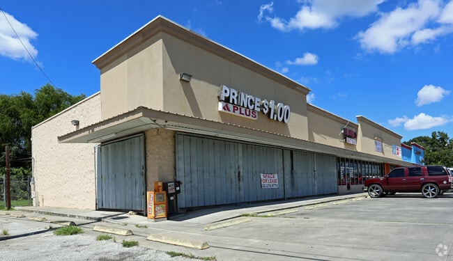
Property Record
11131 Aldine Westfield Rd, Houston, TX 77093

NEARBY LISTINGS FOR SALE OR LEASE
Property Detail
11131 Aldine Westfield Rd
Houston-Pasadena-The Woodlands, TX
Westfield Estates Sec 1
0741350030061
LTS 61 & 62 BLK 3 WESTFIELD ESTATES SEC 1
Stripcommercialcenter
Harris
X
Texas
48201C0490L
61,62
2023
0.32 AC
2025
Near North
221800
Houston
9,500 SF
DEMOGRAPHICS near 11131 Aldine Westfield Rd
1 Mile
3 Mile
5 Mile
2024 Total Population
12,085
113,129
281,926
2029 Population
12,206
114,540
287,780
Pop Growth 2024-2029
+ 1.00%
+ 1.25%
+ 2.08%
Average Age
34
34
36
2024 Total Households
3,256
31,901
88,102
HH Growth 2024-2029
+ 0.95%
+ 1.20%
+ 2.15%
Median Household Inc
$42,500
$36,751
$37,026
Avg Household Size
3.60
3.40
3.10
2024 Avg HH Vehicles
2.00
2.00
2.00
Median Home Value
$125,604
$132,470
$139,280
Median Year Built
1963
1966
1968
Nearby Places
Map Layers
Map Styles
 Street
 Aerial
- Restaurants
- Banks
- Shops
- Fitness
- Groceries
PUBLIC TRANSPORTATION
AIRPORT
George Bush Intcntl/Houston
DRIVE
WALK
Distance
George Bush Intcntl/Houston
14 min
8.9 mi
William P Hobby
DRIVE
WALK
Distance
William P Hobby
37 min
21.7 mi
Freight Ports
Port of Houston
DRIVE
WALK
Distance
Port of Houston
26 min
15.4 mi
SALE & LEASE HISTORY
LISTING DATE
SALE/LEASE

Sep 25, 2016
For Lease
Nearby Properties
Address
Land Use
TOTAL SIZE
Lot Size
Zoning
Address
Land Use
TOTAL SIZE
Lot Size
Zoning
523,480 SF
29.22 AC
Address
Land Use
TOTAL SIZE
Lot Size
Zoning
431,400 SF
30.88 AC
Address
Land Use
TOTAL SIZE
Lot Size
Zoning
545,628 SF
19.41 AC
Address
Land Use
TOTAL SIZE
Lot Size
Zoning
531,786 SF
17.60 AC
Address
Land Use
TOTAL SIZE
Lot Size
Zoning
264,300 SF
15.89 AC
Address
Land Use
TOTAL SIZE
Lot Size
Zoning
236,780 SF
35.30 AC
Address
Land Use
TOTAL SIZE
Lot Size
Zoning
179,804 SF
11.24 AC
Address
Land Use
TOTAL SIZE
Lot Size
Zoning
139,252 SF
4.55 AC
Address
Land Use
TOTAL SIZE
Lot Size
Zoning
132,902 SF
6.12 AC
Address
Land Use
TOTAL SIZE
Lot Size
Zoning
91,623 SF
9.09 AC
Address
Land Use
TOTAL SIZE
Lot Size
Zoning
200,186 SF
13.20 AC
Address
Land Use
TOTAL SIZE
Lot Size
Zoning
261,236 SF
11.57 AC
Address
Land Use
TOTAL SIZE
Lot Size
Zoning
81,067 SF
35.13 AC
Address
Land Use
TOTAL SIZE
Lot Size
Zoning
184,536 SF
10 AC
Address
Land Use
TOTAL SIZE
Lot Size
Zoning
148,981 SF
6.53 AC
Address
Land Use
TOTAL SIZE
Lot Size
Zoning
230,024 SF
15.34 AC
Address
Land Use
TOTAL SIZE
Lot Size
Zoning
112,212 SF
10.51 AC
Address
Land Use
TOTAL SIZE
Lot Size
Zoning
69,777 SF
2.36 AC
Address
Land Use
TOTAL SIZE
Lot Size
Zoning
105,675 SF
10.52 AC
Address
Land Use
TOTAL SIZE
Lot Size
Zoning
130,309 SF
13.28 AC
Address
Land Use
TOTAL SIZE
Lot Size
Zoning
110,250 SF
7.63 AC
Address
Land Use
TOTAL SIZE
Lot Size
Zoning
91,726 SF
6.23 AC
Address
Land Use
TOTAL SIZE
Lot Size
Zoning
82,951 SF
21.32 AC
Address
Land Use
TOTAL SIZE
Lot Size
Zoning
51,941 SF
3.71 AC
Address
Land Use
TOTAL SIZE
Lot Size
Zoning
102,214 SF
11.26 AC
Address
Land Use
TOTAL SIZE
Lot Size
Zoning
352,503 SF
20.41 AC
Address
Land Use
TOTAL SIZE
Lot Size
Zoning
203,960 SF
18 AC
Address
Land Use
TOTAL SIZE
Lot Size
Zoning
160,368 SF
6.25 AC
Address
Land Use
TOTAL SIZE
Lot Size
Zoning
102,252 SF
5.93 AC
Address
Land Use
TOTAL SIZE
Lot Size
Zoning
210,869 SF
8.43 AC
The World's #1 Commercial Real Estate Marketplace
Connect with us
© 2026 CoStar Group
The information above has been obtained from sources believed reliable. While we do not doubt its accuracy we have not verified it and make no guarantee, warranty or representation about it. It is your responsibility to independently confirm its accuracy and completeness. Any projections, opinions, assumptions, or estimates used are for example only and do not represent the current or future performance of the property. The value of this transaction to you depends on tax and other factors which should be evaluated by your tax, financial, and legal advisors. You and your advisors should conduct a careful, independent investigation of the property to determine to your satisfaction the suitability of the property for your needs.