Property Record
11133 Normandy Blvd, Jacksonville, FL 32221
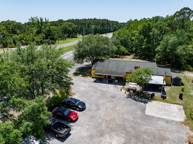

Property Detail
11133 Normandy Blvd
012850-0010
5-93 06-3S-25E 1.234 JACKSONVILLE HEIGHTS PT TRACT 7 RECD O/R 21342-1433 BLK 3
Bartavern
DUVAL
CCG-2
Florida
B and X Area of moderate flood hazard, usually the area between the limits of the 100-year and 500-year floods.
1.24 AC
2025
Riverside
2026
Jacksonville (Florida)
011904
Jacksonville, FL
2,340 SF
NEARBY LISTINGS FOR SALE OR LEASE
DEMOGRAPHICS near 11133 Normandy Blvd
1 mile
3 mile
5 mile
2025 Total Population
4,296
29,762
91,838
2030 Population
4,641
31,894
98,015
Pop Growth 2025-2030
+ 8.03%
+ 7.16%
+ 6.73%
Average Age
37
37
38
2025 Total Households
1,436
10,428
33,173
HH Growth 2025-2030
+ 8.22%
+ 7.36%
+ 6.98%
Median Household Inc
$102,625
$84,815
$74,449
Avg Household Size
3.00
2.80
2.70
2025 Avg HH Vehicles
2.00
2.00
2.00
Median Home Value
$340,412
$323,814
$281,465
Median Year Built
2007
2004
1998
Nearby Places
Map Layers
Map Styles
 Street
 Aerial
Layers
 Traffic
 Biking
Places
Listings with unknown addresses are not visible on the map
- Restaurants
- Banks
- Shops
- Fitness
- Groceries
PUBLIC TRANSPORTATION
AIRPORT
Jacksonville International
Drive
Walk
Distance
Jacksonville International
35 min
23.4 mi
Freight Ports
Jacksonville Port
Drive
Walk
Distance
Jacksonville Port
28 min
16.6 mi
Nearby Properties
Address
Land Use
TOTAL SIZE
Lot Size
Zoning
Address
Land Use
TOTAL SIZE
Lot Size
Zoning
1,020,863 SF
85.89 AC
PUD
Address
Land Use
TOTAL SIZE
Lot Size
Zoning
1,014,416 SF
80.58 AC
PUD
Address
Land Use
TOTAL SIZE
Lot Size
Zoning
1,043,069 SF
62.83 AC
PUD
Address
Land Use
TOTAL SIZE
Lot Size
Zoning
557,137 SF
40.70 AC
PUD
Address
Land Use
TOTAL SIZE
Lot Size
Zoning
239,891 SF
21.95 AC
CRO
Address
Land Use
TOTAL SIZE
Lot Size
Zoning
185,662 SF
1,416.80 AC
PBF-3
Address
Land Use
TOTAL SIZE
Lot Size
Zoning
410,800 SF
35.51 AC
PUD
Address
Land Use
TOTAL SIZE
Lot Size
Zoning
221,429 SF
15.42 AC
PUD
Address
Land Use
TOTAL SIZE
Lot Size
Zoning
307,960 SF
18.52 AC
PUD
Address
Land Use
TOTAL SIZE
Lot Size
Zoning
615,718 SF
43.34 AC
PUD
Address
Land Use
TOTAL SIZE
Lot Size
Zoning
375,127 SF
18.65 AC
PUD
Address
Land Use
TOTAL SIZE
Lot Size
Zoning
280,207 SF
37.53 AC
PUD
Address
Land Use
TOTAL SIZE
Lot Size
Zoning
312,832 SF
46.20 AC
PUD
Address
Land Use
TOTAL SIZE
Lot Size
Zoning
139,435 SF
7.15 AC
CCG-2
Address
Land Use
TOTAL SIZE
Lot Size
Zoning
88,000 SF
11.28 AC
CCG-1
Address
Land Use
TOTAL SIZE
Lot Size
Zoning
136,599 SF
47.95 AC
PBF-2
Address
Land Use
TOTAL SIZE
Lot Size
Zoning
55,621 SF
125.96 AC
PUD
Address
Land Use
TOTAL SIZE
Lot Size
Zoning
65,052 SF
15.97 AC
PUD
Address
Land Use
TOTAL SIZE
Lot Size
Zoning
30,789 SF
2.10 AC
PUD
Address
Land Use
TOTAL SIZE
Lot Size
Zoning
108,217 SF
178.52 AC
PBF-1
Address
Land Use
TOTAL SIZE
Lot Size
Zoning
6,792 SF
53.56 AC
PUD
Address
Land Use
TOTAL SIZE
Lot Size
Zoning
80,512 SF
4.05 AC
PUD
Address
Land Use
TOTAL SIZE
Lot Size
Zoning
237,991 SF
11.82 AC
PUD
Address
Land Use
TOTAL SIZE
Lot Size
Zoning
29,022 SF
3.17 AC
PUD
Address
Land Use
TOTAL SIZE
Lot Size
Zoning
66,892 SF
9.62 AC
PUD
Address
Land Use
TOTAL SIZE
Lot Size
Zoning
33,424 SF
2.97 AC
PUD
Address
Land Use
TOTAL SIZE
Lot Size
Zoning
53,527 SF
10.89 AC
CCG-1
Address
Land Use
TOTAL SIZE
Lot Size
Zoning
53,405 SF
6.04 AC
PUD
Address
Land Use
TOTAL SIZE
Lot Size
Zoning
61,580 SF
15.40 AC
RMD-MH
Address
Land Use
TOTAL SIZE
Lot Size
Zoning
36,354 SF
3.72 AC
CCG-1
The World's #1 Commercial Real Estate Marketplace
Connect with us
© 2026 CoStar Group
The information above has been obtained from sources believed reliable. While we do not doubt its accuracy we have not verified it and make no guarantee, warranty or representation about it. It is your responsibility to independently confirm its accuracy and completeness. Any projections, opinions, assumptions, or estimates used are for example only and do not represent the current or future performance of the property. The value of this transaction to you depends on tax and other factors which should be evaluated by your tax, financial, and legal advisors. You and your advisors should conduct a careful, independent investigation of the property to determine to your satisfaction the suitability of the property for your needs.