Property Record
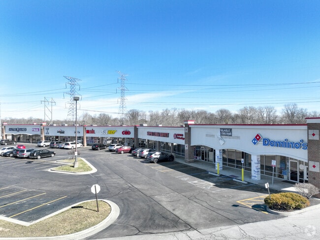
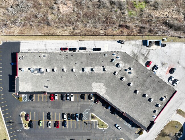
11135 Pendleton Pike, Indianapolis, IN 46236

Property Detail
11135 Pendleton Pike
49-08-03-113-012.000-407
PT W1/2 S3 T16 R5 BEG 352.08 S & 357.31 W OFNE COR W1/2 SW1/4 W 16.18 NW 260.18 NW IRR275.05 NE 29.54 SW 25 NE 2.17 NE IRR 348.15S 570.86 TO BEG 2.65AC
Regionalshoppingcenterormallwithanchorstore
MARION
AE The base floodplain where base flood elevations are provided. AE Zones are now used on new format FIRMs instead of A1-A30 Zones.
Indiana
2024
2.65 AC
2025
North Shadeland
330212
Indianapolis
30,600 SF
Indianapolis-Carmel-Greenwood, IN
NEARBY LISTINGS FOR SALE OR LEASE
DEMOGRAPHICS near 11135 Pendleton Pike
1 mile
3 mile
5 mile
2025 Total Population
6,102
59,508
151,897
2030 Population
6,097
60,393
154,457
Pop Growth 2025-2030
(0.08%)
+ 1.49%
+ 1.69%
Average Age
37
37
37
2025 Total Households
2,156
21,973
58,441
HH Growth 2025-2030
(0.09%)
+ 1.45%
+ 1.62%
Median Household Inc
$109,969
$73,154
$72,260
Avg Household Size
2.80
2.60
2.50
2025 Avg HH Vehicles
2.00
2.00
2.00
Median Home Value
$246,407
$255,800
$268,501
Median Year Built
1999
1992
1984
Nearby Places
Map Layers
Map Styles
 Street
 Aerial
Transit
 Traffic
 Biking
Places
Listings with unknown addresses are not visible on the map
- Restaurants
- Banks
- Shops
- Fitness
- Groceries
PUBLIC TRANSPORTATION
AIRPORT
Indianapolis International
Drive
Walk
Distance
Indianapolis International
48 min
27.1 mi
Freight Ports
Port of Toledo
Drive
Walk
Distance
Port of Toledo
256 min
212.0 mi
SALE & LEASE HISTORY
LISTING DATE
SALE/LEASE

Sep 24, 2016
For Lease
Aug 22, 2017
For Lease
Aug 21, 2017
For Lease
Aug 18, 2022
For Lease
Nearby Properties
Address
Land Use
TOTAL SIZE
Lot Size
Zoning
Address
Land Use
TOTAL SIZE
Lot Size
Zoning
77.34 AC
Address
Land Use
TOTAL SIZE
Lot Size
Zoning
67.17 AC
Address
Land Use
TOTAL SIZE
Lot Size
Zoning
986,112 SF
41.42 AC
Address
Land Use
TOTAL SIZE
Lot Size
Zoning
1,720 SF
63.09 AC
Address
Land Use
TOTAL SIZE
Lot Size
Zoning
2,398 SF
64.58 AC
Address
Land Use
TOTAL SIZE
Lot Size
Zoning
Address
Land Use
TOTAL SIZE
Lot Size
Zoning
11,154 SF
21.99 AC
Address
Land Use
TOTAL SIZE
Lot Size
Zoning
532,932 SF
61.88 AC
ZO03
Address
Land Use
TOTAL SIZE
Lot Size
Zoning
4,217 SF
7.37 AC
ZO01
Address
Land Use
TOTAL SIZE
Lot Size
Zoning
2,620 SF
32.36 AC
Address
Land Use
TOTAL SIZE
Lot Size
Zoning
125,958 SF
54.85 AC
ZO01
Address
Land Use
TOTAL SIZE
Lot Size
Zoning
28.71 AC
Address
Land Use
TOTAL SIZE
Lot Size
Zoning
2,556 SF
35.56 AC
ZO01
Address
Land Use
TOTAL SIZE
Lot Size
Zoning
455,424 SF
33.96 AC
Address
Land Use
TOTAL SIZE
Lot Size
Zoning
2,232 SF
22.88 AC
Address
Land Use
TOTAL SIZE
Lot Size
Zoning
136,336 SF
8.74 AC
ZO01
Address
Land Use
TOTAL SIZE
Lot Size
Zoning
259,780 SF
20.36 AC
Address
Land Use
TOTAL SIZE
Lot Size
Zoning
1,769 SF
18.27 AC
Address
Land Use
TOTAL SIZE
Lot Size
Zoning
27.17 AC
Address
Land Use
TOTAL SIZE
Lot Size
Zoning
24.25 AC
Address
Land Use
TOTAL SIZE
Lot Size
Zoning
16,836 SF
16.90 AC
Address
Land Use
TOTAL SIZE
Lot Size
Zoning
65,095 SF
4.06 AC
ZO01
Address
Land Use
TOTAL SIZE
Lot Size
Zoning
2,151 SF
11.05 AC
Address
Land Use
TOTAL SIZE
Lot Size
Zoning
293,952 SF
12.88 AC
ZO01
Address
Land Use
TOTAL SIZE
Lot Size
Zoning
19.12 AC
Address
Land Use
TOTAL SIZE
Lot Size
Zoning
109,200 SF
4.63 AC
ZO01
Address
Land Use
TOTAL SIZE
Lot Size
Zoning
245,200 SF
12.08 AC
Address
Land Use
TOTAL SIZE
Lot Size
Zoning
31.13 AC
Address
Land Use
TOTAL SIZE
Lot Size
Zoning
43,530 SF
5.06 AC
Address
Land Use
TOTAL SIZE
Lot Size
Zoning
203,720 SF
21.44 AC
The World's #1 Commercial Real Estate Marketplace
Connect with us
© 2026 CoStar Group
The information above has been obtained from sources believed reliable. While we do not doubt its accuracy we have not verified it and make no guarantee, warranty or representation about it. It is your responsibility to independently confirm its accuracy and completeness. Any projections, opinions, assumptions, or estimates used are for example only and do not represent the current or future performance of the property. The value of this transaction to you depends on tax and other factors which should be evaluated by your tax, financial, and legal advisors. You and your advisors should conduct a careful, independent investigation of the property to determine to your satisfaction the suitability of the property for your needs.