Property Record
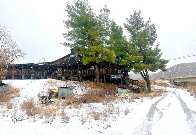
11135 S State Route 69, Mayer, AZ 86333

NEARBY LISTINGS FOR SALE OR LEASE
Property Detail
11135 S State Route 69
Prescott, AZ
Yavapai
500-24-002G
Arizona
Storemultistory
6.02 AC
AE
Prescott & Sedona
04025C2490H
Other Market Areas
10,972 SF
DEMOGRAPHICS near 11135 S State Route 69
1 Mile
3 Mile
5 Mile
2024 Total Population
54
684
2,399
2029 Population
55
740
2,687
Pop Growth 2024-2029
+ 1.85%
+ 8.19%
+ 12.01%
Average Age
50
49
49
2024 Total Households
25
314
1,101
HH Growth 2024-2029
+ 4.00%
+ 8.60%
+ 12.44%
Median Household Inc
$51,250
$49,999
$45,513
Avg Household Size
2.00
2.10
2.10
2024 Avg HH Vehicles
2.00
2.00
2.00
Median Home Value
$199,999
$185,293
$169,736
Median Year Built
1986
1988
1992
Nearby Places
Map Layers
Map Styles
 Street
 Aerial
- Restaurants
- Banks
- Shops
- Fitness
- Groceries
SALE & LEASE HISTORY
LISTING DATE
SALE/LEASE

Sep 23, 2016
For Sale
Nov 30, 2016
For Sale
Jun 13, 2024
For Sale
Feb 12, 2025
For Lease
Feb 12, 2025
For Sale
Nearby Properties
Address
Land Use
TOTAL SIZE
Lot Size
Zoning
Address
Land Use
TOTAL SIZE
Lot Size
Zoning
50,757 SF
7.24 AC
Address
Land Use
TOTAL SIZE
Lot Size
Zoning
16,549 SF
34.61 AC
Address
Land Use
TOTAL SIZE
Lot Size
Zoning
9,600 SF
2.01 AC
Address
Land Use
TOTAL SIZE
Lot Size
Zoning
16,680 SF
4.27 AC
Address
Land Use
TOTAL SIZE
Lot Size
Zoning
1,440 SF
10.04 AC
Address
Land Use
TOTAL SIZE
Lot Size
Zoning
6,030 SF
1.15 AC
Address
Land Use
TOTAL SIZE
Lot Size
Zoning
9,672 SF
1.17 AC
Address
Land Use
TOTAL SIZE
Lot Size
Zoning
11,892 SF
1.23 AC
Address
Land Use
TOTAL SIZE
Lot Size
Zoning
8,222 SF
0.42 AC
Address
Land Use
TOTAL SIZE
Lot Size
Zoning
6,077 SF
3.87 AC
Address
Land Use
TOTAL SIZE
Lot Size
Zoning
7,451 SF
1.03 AC
Address
Land Use
TOTAL SIZE
Lot Size
Zoning
4,384 SF
0.84 AC
Address
Land Use
TOTAL SIZE
Lot Size
Zoning
279.04 AC
Address
Land Use
TOTAL SIZE
Lot Size
Zoning
3,360 SF
0.97 AC
Address
Land Use
TOTAL SIZE
Lot Size
Zoning
4,870 SF
0.85 AC
Address
Land Use
TOTAL SIZE
Lot Size
Zoning
3,590 SF
12.05 AC
Address
Land Use
TOTAL SIZE
Lot Size
Zoning
6,101 SF
0.90 AC
Address
Land Use
TOTAL SIZE
Lot Size
Zoning
3,044 SF
0.21 AC
Address
Land Use
TOTAL SIZE
Lot Size
Zoning
24 SF
6.34 AC
Address
Land Use
TOTAL SIZE
Lot Size
Zoning
4,919 SF
0.80 AC
Address
Land Use
TOTAL SIZE
Lot Size
Zoning
6,225 SF
1.30 AC
Address
Land Use
TOTAL SIZE
Lot Size
Zoning
3,240 SF
4.25 AC
Address
Land Use
TOTAL SIZE
Lot Size
Zoning
2,886 SF
10.38 AC
Address
Land Use
TOTAL SIZE
Lot Size
Zoning
2,548 SF
4.90 AC
Address
Land Use
TOTAL SIZE
Lot Size
Zoning
2,688 SF
4.06 AC
Address
Land Use
TOTAL SIZE
Lot Size
Zoning
Address
Land Use
TOTAL SIZE
Lot Size
Zoning
3,054 SF
0.88 AC
Address
Land Use
TOTAL SIZE
Lot Size
Zoning
3,796 SF
0.53 AC
The World's #1 Commercial Real Estate Marketplace
Connect with us
© 2025 CoStar Group
The information above has been obtained from sources believed reliable. While we do not doubt its accuracy we have not verified it and make no guarantee, warranty or representation about it. It is your responsibility to independently confirm its accuracy and completeness. Any projections, opinions, assumptions, or estimates used are for example only and do not represent the current or future performance of the property. The value of this transaction to you depends on tax and other factors which should be evaluated by your tax, financial, and legal advisors. You and your advisors should conduct a careful, independent investigation of the property to determine to your satisfaction the suitability of the property for your needs.