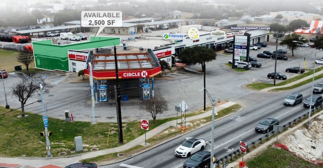
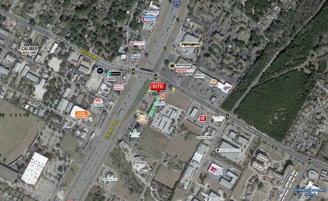
Property Record
11139 N Interstate 35, Austin, TX 78753

NEARBY LISTINGS FOR SALE OR LEASE
Property Detail
11139 N Interstate 35
Austin-Round Rock, TX
Braker Lane Iii
746280
2.0219AC OF LOT 2 BRAKER LANE III
Stripcommercialcenter
Travis
X
Texas
48453C0270J
2
2024
2.02 AC
2025
Northeast
041600
Austin
22,378 SF
DEMOGRAPHICS near 11139 N Interstate 35
1 Mile
3 Mile
5 Mile
2024 Total Population
12,268
127,164
316,058
2029 Population
13,211
138,134
343,487
Pop Growth 2024-2029
+ 7.69%
+ 8.63%
+ 8.68%
Average Age
40
36
37
2024 Total Households
4,630
50,559
134,136
HH Growth 2024-2029
+ 8.44%
+ 9.36%
+ 9.38%
Median Household Inc
$63,389
$58,279
$69,714
Avg Household Size
2.50
2.40
2.30
2024 Avg HH Vehicles
2.00
2.00
2.00
Median Home Value
$312,693
$305,116
$366,324
Median Year Built
1982
1990
1990
Nearby Places
Map Layers
Map Styles
 Street
 Aerial
- Restaurants
- Banks
- Shops
- Fitness
- Groceries
PUBLIC TRANSPORTATION
AIRPORT
Austin-Bergstrom International
DRIVE
WALK
Distance
Austin-Bergstrom International
31 min
19.1 mi
SALE & LEASE HISTORY
LISTING DATE
SALE/LEASE

Sep 24, 2016
For Lease
Sep 24, 2016
For Lease
Nov 30, 2021
For Sale
May 16, 2018
For Lease
Jul 12, 2022
For Sale
Aug 12, 2020
For Lease
Apr 10, 2017
For Lease
Nearby Properties
Address
Land Use
TOTAL SIZE
Lot Size
Zoning
Address
Land Use
TOTAL SIZE
Lot Size
Zoning
230.30 AC
Address
Land Use
TOTAL SIZE
Lot Size
Zoning
702,590 SF
48.64 AC
Address
Land Use
TOTAL SIZE
Lot Size
Zoning
1,145,461 SF
34.05 AC
Address
Land Use
TOTAL SIZE
Lot Size
Zoning
571,738 SF
36.06 AC
Address
Land Use
TOTAL SIZE
Lot Size
Zoning
368,100 SF
38.07 AC
Address
Land Use
TOTAL SIZE
Lot Size
Zoning
311,025 SF
4.99 AC
Address
Land Use
TOTAL SIZE
Lot Size
Zoning
287,272 SF
17.68 AC
Address
Land Use
TOTAL SIZE
Lot Size
Zoning
348,496 SF
17.59 AC
Address
Land Use
TOTAL SIZE
Lot Size
Zoning
351,012 SF
16.40 AC
Address
Land Use
TOTAL SIZE
Lot Size
Zoning
314,319 SF
5.97 AC
Address
Land Use
TOTAL SIZE
Lot Size
Zoning
377,769 SF
20.97 AC
Address
Land Use
TOTAL SIZE
Lot Size
Zoning
379,500 SF
17.99 AC
Address
Land Use
TOTAL SIZE
Lot Size
Zoning
286,276 SF
4.53 AC
Address
Land Use
TOTAL SIZE
Lot Size
Zoning
6,498 SF
236.84 AC
Address
Land Use
TOTAL SIZE
Lot Size
Zoning
359,458 SF
18.50 AC
Address
Land Use
TOTAL SIZE
Lot Size
Zoning
299,957 SF
22.02 AC
Address
Land Use
TOTAL SIZE
Lot Size
Zoning
709,789 SF
52.90 AC
Address
Land Use
TOTAL SIZE
Lot Size
Zoning
307,036 SF
21.64 AC
Address
Land Use
TOTAL SIZE
Lot Size
Zoning
521,820 SF
4.68 AC
Address
Land Use
TOTAL SIZE
Lot Size
Zoning
459,304 SF
28.36 AC
Address
Land Use
TOTAL SIZE
Lot Size
Zoning
752,804 SF
180.91 AC
Address
Land Use
TOTAL SIZE
Lot Size
Zoning
244,809 SF
5.45 AC
Address
Land Use
TOTAL SIZE
Lot Size
Zoning
401,976 SF
38.07 AC
Address
Land Use
TOTAL SIZE
Lot Size
Zoning
311,850 SF
18.09 AC
Address
Land Use
TOTAL SIZE
Lot Size
Zoning
270,780 SF
18.17 AC
Address
Land Use
TOTAL SIZE
Lot Size
Zoning
323,425 SF
14.20 AC
Address
Land Use
TOTAL SIZE
Lot Size
Zoning
384,776 SF
22.88 AC
Address
Land Use
TOTAL SIZE
Lot Size
Zoning
313,414 SF
37.71 AC
Address
Land Use
TOTAL SIZE
Lot Size
Zoning
264,401 SF
10.48 AC
Address
Land Use
TOTAL SIZE
Lot Size
Zoning
374,432 SF
14.28 AC
The World's #1 Commercial Real Estate Marketplace
Connect with us
© 2025 CoStar Group
The information above has been obtained from sources believed reliable. While we do not doubt its accuracy we have not verified it and make no guarantee, warranty or representation about it. It is your responsibility to independently confirm its accuracy and completeness. Any projections, opinions, assumptions, or estimates used are for example only and do not represent the current or future performance of the property. The value of this transaction to you depends on tax and other factors which should be evaluated by your tax, financial, and legal advisors. You and your advisors should conduct a careful, independent investigation of the property to determine to your satisfaction the suitability of the property for your needs.