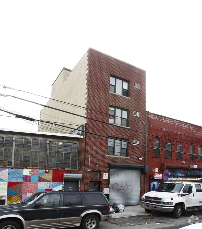
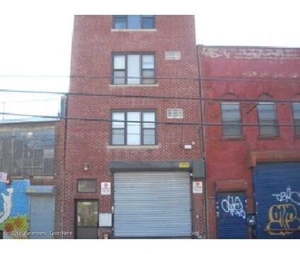
Property Record
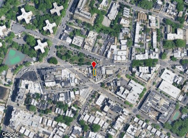
1114 Main Ave, Astoria, NY 11102
NEARBY LISTINGS FOR SALE OR LEASE
Property Detail
1114 Main Ave
00513-0030
Queens
Commercialofficeresidentialmixeduse
New York
X
30
3604970093F
0.03 AC
2024
Northwest Queens
2025
Long Island (New York)
008100
New York-Jersey City-White Plains, NY-NJ
3,800 SF
DEMOGRAPHICS near 1114 Main Ave
1 mile
3 mile
5 mile
2024 Total Population
130,187
1,163,683
2,987,438
2029 Population
123,121
1,084,858
2,791,328
Pop Growth 2024-2029
(5.43%)
(6.77%)
(6.56%)
Average Age
41
41
40
2024 Total Households
61,025
537,134
1,269,652
HH Growth 2024-2029
(5.83%)
(7.00%)
(6.85%)
Median Household Inc
$90,470
$88,362
$74,323
Avg Household Size
2.10
2.10
2.20
2024 Avg HH Vehicles
.00
.00
.00
Median Home Value
$848,503
$921,092
$821,827
Median Year Built
1954
1955
1955
Nearby Places
Map Layers
Map Styles
 Street
 Aerial
Transit
 Traffic
 Biking
Places
Listings with unknown addresses are not visible on the map
- Restaurants
- Banks
- Shops
- Fitness
- Groceries
PUBLIC TRANSPORTATION
TRANSIT/SUBWAY
30 Avenue (N - New York MTA Subway (The Subway), Q - New York MTA Subway (The Subway))
Drive
Walk
Distance
30 Avenue (N - New York MTA Subway (The Subway), Q - New York MTA Subway (The Subway))
3 min
13 min
0.7 mi
Astoria Boulevard (N - New York MTA Subway (The Subway), Q - New York MTA Subway (The Subway))
Drive
Walk
Distance
Astoria Boulevard (N - New York MTA Subway (The Subway), Q - New York MTA Subway (The Subway))
14 min
15 min
0.8 mi
Broadway (N Line) (N - New York MTA Subway (The Subway), Q - New York MTA Subway (The Subway))
Drive
Walk
Distance
Broadway (N Line) (N - New York MTA Subway (The Subway), Q - New York MTA Subway (The Subway))
3 min
20 min
1.1 mi
COMMUTER RAIL
Hunterspoint Avenue Station (Hempstead Branch - Long Island Rail Road, Oyster Bay Branch - Long Island Rail Road)
Drive
Walk
Distance
Hunterspoint Avenue Station (Hempstead Branch - Long Island Rail Road, Oyster Bay Branch - Long Island Rail Road)
6 min
2.7 mi
Long Island City Station (Hempstead Branch - Long Island Rail Road)
Drive
Walk
Distance
Long Island City Station (Hempstead Branch - Long Island Rail Road)
8 min
3.1 mi
AIRPORT
LaGuardia
Drive
Walk
Distance
LaGuardia
8 min
3.4 mi
John F Kennedy International
Drive
Walk
Distance
John F Kennedy International
21 min
14.6 mi
Newark Liberty International
Drive
Walk
Distance
Newark Liberty International
30 min
19.1 mi
Freight Ports
NY - Red Hook Container Terminal
Drive
Walk
Distance
NY - Red Hook Container Terminal
20 min
9.5 mi
Nearby Properties
Address
Land Use
TOTAL SIZE
Lot Size
Zoning
Address
Land Use
TOTAL SIZE
Lot Size
Zoning
97.14 AC
R7-2
Address
Land Use
TOTAL SIZE
Lot Size
Zoning
1.22 AC
R7-2
Address
Land Use
TOTAL SIZE
Lot Size
Zoning
0.92 AC
R7-2
Address
Land Use
TOTAL SIZE
Lot Size
Zoning
97.14 AC
R7-2
Address
Land Use
TOTAL SIZE
Lot Size
Zoning
1,783,434 SF
1.94 AC
C5-3
Address
Land Use
TOTAL SIZE
Lot Size
Zoning
2,636,182 SF
2.35 AC
C65.5
Address
Land Use
TOTAL SIZE
Lot Size
Zoning
4,380,201 SF
97.06 AC
R7-2
Address
Land Use
TOTAL SIZE
Lot Size
Zoning
5,519,372 SF
409.21 AC
C8-2
Address
Land Use
TOTAL SIZE
Lot Size
Zoning
2,734,038 SF
4.24 AC
C52.5
Address
Land Use
TOTAL SIZE
Lot Size
Zoning
1,678,135 SF
1.01 AC
C5-3
Address
Land Use
TOTAL SIZE
Lot Size
Zoning
1,897,491 SF
2.06 AC
C52.5
Address
Land Use
TOTAL SIZE
Lot Size
Zoning
1,233,684 SF
16.94 AC
PARK
Address
Land Use
TOTAL SIZE
Lot Size
Zoning
1,638,259 SF
1.43 AC
C52.5
Address
Land Use
TOTAL SIZE
Lot Size
Zoning
2,360,627 SF
2.08 AC
C6-7
Address
Land Use
TOTAL SIZE
Lot Size
Zoning
1,984,228 SF
1.95 AC
C65.5
Address
Land Use
TOTAL SIZE
Lot Size
Zoning
1,586,876 SF
1.87 AC
C5-3
Address
Land Use
TOTAL SIZE
Lot Size
Zoning
1,962,900 SF
1.89 AC
C66.5
Address
Land Use
TOTAL SIZE
Lot Size
Zoning
1,842,991 SF
2.08 AC
C66.5
Address
Land Use
TOTAL SIZE
Lot Size
Zoning
1,613,847 SF
1.84 AC
C66.5
Address
Land Use
TOTAL SIZE
Lot Size
Zoning
2,215,000 SF
6.43 AC
R9
Address
Land Use
TOTAL SIZE
Lot Size
Zoning
1,596,521 SF
1.34 AC
C6-4
Address
Land Use
TOTAL SIZE
Lot Size
Zoning
2,344,406 SF
1.84 AC
C5-3
Address
Land Use
TOTAL SIZE
Lot Size
Zoning
264,420 SF
7.26 AC
C4-7
Address
Land Use
TOTAL SIZE
Lot Size
Zoning
431,963 SF
C67T
Address
Land Use
TOTAL SIZE
Lot Size
Zoning
1,448,897 SF
1.56 AC
C6-6
Address
Land Use
TOTAL SIZE
Lot Size
Zoning
2,400,000 SF
15.14 AC
C5-2
Address
Land Use
TOTAL SIZE
Lot Size
Zoning
1,606,528 SF
1.84 AC
C6-6
Address
Land Use
TOTAL SIZE
Lot Size
Zoning
1,169,666 SF
1.42 AC
C52.5
Address
Land Use
TOTAL SIZE
Lot Size
Zoning
1,482,208 SF
1.71 AC
C5-3
Address
Land Use
TOTAL SIZE
Lot Size
Zoning
1,160,500 SF
1.62 AC
C6-6
The World's #1 Commercial Real Estate Marketplace
Connect with us
© 2026 CoStar Group
The information above has been obtained from sources believed reliable. While we do not doubt its accuracy we have not verified it and make no guarantee, warranty or representation about it. It is your responsibility to independently confirm its accuracy and completeness. Any projections, opinions, assumptions, or estimates used are for example only and do not represent the current or future performance of the property. The value of this transaction to you depends on tax and other factors which should be evaluated by your tax, financial, and legal advisors. You and your advisors should conduct a careful, independent investigation of the property to determine to your satisfaction the suitability of the property for your needs.